File:Dakar Rally 2011 map-en.svg
Jump to navigation
Jump to search

Size of this PNG preview of this SVG file: 573 × 600 pixels. Other resolutions: 229 × 240 pixels | 458 × 480 pixels | 734 × 768 pixels | 978 × 1,024 pixels | 1,956 × 2,048 pixels | 1,513 × 1,584 pixels.
Original file (SVG file, nominally 1,513 × 1,584 pixels, file size: 3.42 MB)
Captions
Captions
Add a one-line explanation of what this file represents
Summary
[edit]
| Description |
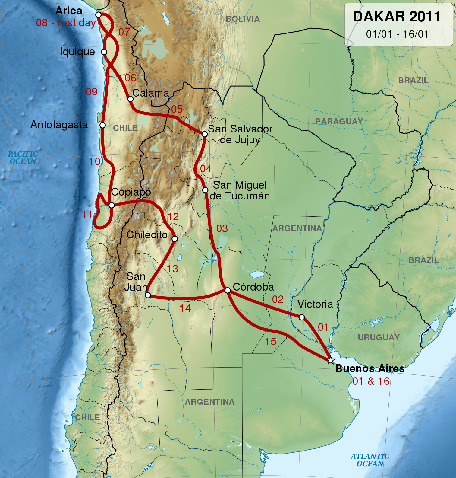
English: Map of 2011 Dakar Rally track, in English.
Français : Carte du trajet du Rallye Dakar 2011, en anglas.
Español: Mapa del circuito del Rally Dakar de 2011, en inglés.
UTM projection. |
| Date | |
| Source |
Own work. Sources of data:
|
| Author | Sémhur |
| Permission (Reusing this file) |
Attribution and Share-Alike required: any use of this picture can be made as long as you credit me (Wikimedia Commons user: Sémhur) as the creator and distribute the copies and derivative works under the same license that the one indicated below. |
| Other versions |
Derivative works of this file: Dakar Rally 2011 map-cs.svg
[] |
| Attribution (required by the license) | © Sémhur / Wikimedia Commons / |
| SVG development |
| Object location | | View this and other nearby images on: OpenStreetMap |
|---|
Licensing
[edit]
I, the copyright holder of this work, hereby publish it under the following licenses:
| Copyleft: This work of art is free; you can redistribute it and/or modify it according to terms of the Free Art License. You will find a specimen of this license on the Copyleft Attitude site as well as on other sites. |
This file is licensed under the Creative Commons Attribution-Share Alike 4.0 International, 3.0 Unported, 2.5 Generic, 2.0 Generic and 1.0 Generic license.
- You are free:
- to share – to copy, distribute and transmit the work
- to remix – to adapt the work
- Under the following conditions:
- attribution – You must give appropriate credit, provide a link to the license, and indicate if changes were made. You may do so in any reasonable manner, but not in any way that suggests the licensor endorses you or your use.
- share alike – If you remix, transform, or build upon the material, you must distribute your contributions under the same or compatible license as the original.
You may select the license of your choice.
File history
Click on a date/time to view the file as it appeared at that time.
| Date/Time | Thumbnail | Dimensions | User | Comment | |
|---|---|---|---|---|---|
| current | 20:45, 21 May 2014 | | 1,513 × 1,584 (3.42 MB) | Sémhur (talk | contribs) | Valid SVG |
| 19:42, 15 December 2010 |  | 1,513 × 1,584 (3.42 MB) | Sémhur (talk | contribs) | == {{int:filedesc}} == {{Information |Description= {{en|1=Map of 2011 Dakar Rally track, in English.}} {{fr|1=Carte du trajet du Rallye Dakar 2011, en anglas.}} {{es|1=Mapa del circuito del [[:es:Rally Da |
You cannot overwrite this file.
File usage on Commons
The following 2 pages use this file:
File usage on other wikis
The following other wikis use this file:
- Usage on bg.wikipedia.org
- Usage on ca.wikipedia.org
- Usage on de.wikipedia.org
- Usage on en.wikipedia.org
- Usage on hu.wikipedia.org
- Usage on it.wikipedia.org
- Usage on nl.wikipedia.org
- Usage on pl.wikipedia.org
- Usage on pt.wikipedia.org
- Usage on ro.wikipedia.org
- Usage on ru.wikipedia.org
- Usage on www.wikidata.org
- Usage on zh.wikipedia.org