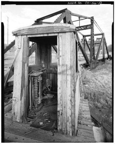
File:DETAIL OF TURNTABLE CONTROL HOUSE, SHOWING ELECTRICAL SWITCHES, WITH TURNTABLE IN BACKGROUND. VIEW TO NORTHWEST. - Colorado and Southern Railway Denver Roundhouse Complex, HAER COLO,16-DENV,55-10.tif
Jump to navigation
Jump to search

Size of this JPG preview of this TIF file: 479 × 599 pixels. Other resolutions: 192 × 240 pixels | 384 × 480 pixels | 614 × 768 pixels | 819 × 1,024 pixels | 1,638 × 2,048 pixels | 4,066 × 5,083 pixels.
Original file (4,066 × 5,083 pixels, file size: 19.71 MB, MIME type: image/tiff)
Captions
Captions
Add a one-line explanation of what this file represents
Summary
[edit]| DETAIL OF TURNTABLE CONTROL HOUSE, SHOWING ELECTRICAL SWITCHES, WITH TURNTABLE IN BACKGROUND. VIEW TO NORTHWEST. - Colorado and Southern Railway Denver Roundhouse Complex, Seventh Street, East of South Platte River, Denver, Denver County, CO | ||||
|---|---|---|---|---|
| Photographer |
Related names:
|
|||
| Title |
DETAIL OF TURNTABLE CONTROL HOUSE, SHOWING ELECTRICAL SWITCHES, WITH TURNTABLE IN BACKGROUND. VIEW TO NORTHWEST. - Colorado and Southern Railway Denver Roundhouse Complex, Seventh Street, East of South Platte River, Denver, Denver County, CO |
|||
| Depicted place | Colorado; Denver County; Denver | |||
| Date | Documentation compiled after 1968 | |||
| Dimensions | 4 x 5 in. | |||
| Current location |
Library of Congress Prints and Photographs Division Washington, D.C. 20540 USA http://hdl.loc.gov/loc.pnp/pp.print |
|||
| Accession number |
HAER COLO,16-DENV,55-10 |
|||
| Credit line |
|
|||
| Notes |
|
|||
| Source | https://www.loc.gov/pictures/item/co0222.photos.021027p | |||
| Permission (Reusing this file) |
|
|||

| Object location | | View this and other nearby images on: OpenStreetMap |
|---|
File history
Click on a date/time to view the file as it appeared at that time.
| Date/Time | Thumbnail | Dimensions | User | Comment | |
|---|---|---|---|---|---|
| current | 19:45, 8 July 2014 |  | 4,066 × 5,083 (19.71 MB) | Fæ (talk | contribs) | GWToolset: Creating mediafile for Fæ. HABS 05 July 2014 (501:600) |
You cannot overwrite this file.
File usage on Commons
The following page uses this file: