File:Cyprus ESA356100.tiff

Original file (10,000 × 7,196 pixels, file size: 205.9 MB, MIME type: image/tiff)
Captions
Captions
Summary
[edit]| Warning | The original file is very high-resolution. It might not load properly or could cause your browser to freeze when opened at full size. |
|---|
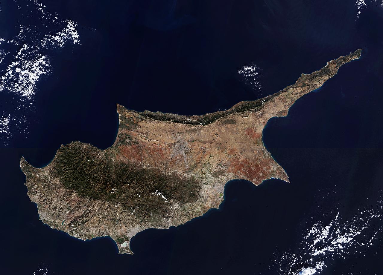
| Description |
English: The third largest island in the Mediterranean, Cyprus is about 240 km long and 100 km wide. It is located on the Anatolian plate and therefore belongs geologically to Asia, but politically it is a member of the EU.
The Troodos mountains dominate the centre of the island and include Mount Olympus, the country’s highest mountain at 1952 m. Along the northern coast, the smaller Kyrenia Range rises suddenly from the plains. The capital and largest city, Nicosia, sits between the two mountain ranges. Since 1974 the island has been split between the Greek Cypriot and Turkish Cypriot populations, with the line of separation running through the city. East of Nicosia lies the Mesaoria plain, which is the agricultural heartland of the island – but depends greatly on winter rainfall and irrigation, limiting its production. High summer temperatures further exacerbate the situation. Thousands of years ago the area was covered by thick forest, but most of this was cut down to provide wood for the Ptolemaic dynasty’s navy in the 1st century BC. Today, much of the plain is covered by hard-packed calcium carbonate. At the southernmost area of Cyprus we can see the Limassol Salt Lake, the largest inland body of water on the island. Covering over 10 sq km, the lake is an important stopover for birds migrating between Africa and Europe, with greater flamingos spending the winter months there. Further up the coast to the east is the seasonal Larnaca Salt Lake, which also sees flamingos. This image – also featured on theEarth from Space video programme– comprises two scans from the Sentinel-2A satellite on the same day: 22 December 2015. |
| Date | |
| Source | http://www.esa.int/spaceinimages/Images/2016/03/Cyprus |
| Author | European Space Agency |
| Permission (Reusing this file) |
Copernicus Sentinel data (2015)/ESA,CC BY-SA 3.0 IGO |
| Other versions |
|
| Title | Cyprus |
| Set | Earth observation image of the week |
| System | Copernicus |
| Mission | Sentinel-2 |
| Location | Cyprus |
| Activity | Observing the Earth |
| Keywords | Satellite image; Islands; Coast; Coast line; Mountain |

Licensing
[edit]- You are free:
- to share – to copy, distribute and transmit the work
- to remix – to adapt the work
- Under the following conditions:
- attribution – You must give appropriate credit, provide a link to the license, and indicate if changes were made. You may do so in any reasonable manner, but not in any way that suggests the licensor endorses you or your use.
- share alike – If you remix, transform, or build upon the material, you must distribute your contributions under the same or compatible license as the original.

|
This image contains data from a satellite in the Copernicus Programme, such as Sentinel-1, Sentinel-2 or Sentinel-3. Attribution is required when using this image.
Attribution: Contains modified Copernicus Sentinel data {{{year}}}
The use of Copernicus Sentinel Data is regulated under EU law (Commission Delegated Regulation (EU) No 1159/2013 and Regulation (EU) No 377/2014). Relevant excerpts:
Free access shall be given to GMES dedicated data [...] made available through GMES dissemination platforms [...].
Access to GMES dedicated data [...] shall be given for the purpose of the following use in so far as it is lawful:
GMES dedicated data [...] may be used worldwide without limitations in time.
GMES dedicated data and GMES service information are provided to users without any express or implied warranty, including as regards quality and suitability for any purpose. |
File history
Click on a date/time to view the file as it appeared at that time.
| Date/Time | Thumbnail | Dimensions | User | Comment | |
|---|---|---|---|---|---|
| current | 20:27, 7 May 2017 |  | 10,000 × 7,196 (205.9 MB) | Fæ (talk | contribs) | == {{int:filedesc}} == {{information | description = {{en|1=The third largest island in the Mediterranean, Cyprus is about 240 km long and 100 km wide. It is located on the Anatolian plate and therefore belongs geologically to Asia, but politically it... |
You cannot overwrite this file.
File usage on Commons
The following 3 pages use this file:
.jpg)
.jpg)