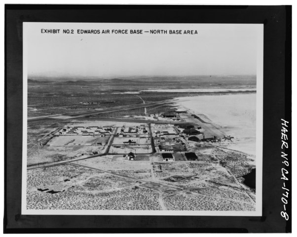
File:Credit USAF, ca. 1952. Original housed in the Photograph Files, AFFTC-HO, Edwards AFB, California. Oblique low-level aerial view of North Base looking northeast. Based on HAER CAL,15-BORON.V,2-8.tif
Jump to navigation
Jump to search

Size of this JPG preview of this TIF file: 752 × 600 pixels. Other resolutions: 301 × 240 pixels | 602 × 480 pixels | 963 × 768 pixels | 1,280 × 1,021 pixels | 2,560 × 2,042 pixels | 5,117 × 4,082 pixels.
Original file (5,117 × 4,082 pixels, file size: 19.92 MB, MIME type: image/tiff)
Captions
Captions
Add a one-line explanation of what this file represents
Summary
[edit]| Photographer |
Related names:
|
|||
| Title |
Credit USAF, ca. 1952. Original housed in the Photograph Files, AFFTC-HO, Edwards AFB, California. Oblique low-level aerial view of North Base looking northeast. Based on positions and types of aircraft and automobiles, this photo taken same day as HAER photo CA-170-7. Most temporary structures in this view have been demolished with the exception of the hangars. The concrete foundations remain of many structures, while no trace was found of others. - Edwards Air Force Base, North Base, North Base Road, Boron, Kern County, CA |
|||
| Depicted place | California; Kern County; Boron | |||
| Date | Documentation compiled after 1968 | |||
| Dimensions | 4 x 5 in. | |||
| Current location |
Library of Congress Prints and Photographs Division Washington, D.C. 20540 USA http://hdl.loc.gov/loc.pnp/pp.print |
|||
| Accession number |
HAER CAL,15-BORON.V,2-8 |
|||
| Credit line |
|
|||
| Notes |
|
|||
| Source | https://www.loc.gov/pictures/item/ca2142.photos.384016p | |||
| Permission (Reusing this file) |
|

| Object location | | View this and other nearby images on: OpenStreetMap |
|---|
File history
Click on a date/time to view the file as it appeared at that time.
| Date/Time | Thumbnail | Dimensions | User | Comment | |
|---|---|---|---|---|---|
| current | 19:57, 5 July 2014 |  | 5,117 × 4,082 (19.92 MB) | Fæ (talk | contribs) | GWToolset: Creating mediafile for Fæ. HABS 05 July 2014 (401:500) |
You cannot overwrite this file.
File usage on Commons
The following page uses this file: