File:Cove at Start Point - geograph.org.uk - 1335981.jpg
Jump to navigation
Jump to search
No higher resolution available.
Cove_at_Start_Point_-_geograph.org.uk_-_1335981.jpg (640 × 480 pixels, file size: 238 KB, MIME type: image/jpeg)
Captions
Captions
Add a one-line explanation of what this file represents
Summary
[edit]
| Description |
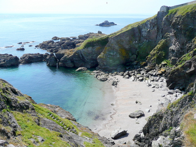
English: Cove at Start Point. View south. The Point proper is at the southern arm of the enclosing cliffs of this cove. That side is inaccessible on account of the eroded path (1335963). A fog horn mechanism can be seen vertically descending the cliff to the right.
The view from the north arm, Froweder Point, shows part of the stepped path cut into the rock to allow access to the beach. Even so it is quite a scramble. I gained permission to get out to Froweder Point from the caretaker of the Trinity House property - thank you. Black Stone in SX8336 is beyond. |
| Date | |
| Source | From geograph.org.uk |
| Author | Jonathan Billinger |
| Attribution (required by the license) | Jonathan Billinger / Cove at Start Point / |
| Camera location | | View this and other nearby images on: OpenStreetMap |
|---|
_heading:180.00&language=en)
| Object location | | View this and other nearby images on: OpenStreetMap |
|---|
_heading:180.00&language=en)
Licensing
[edit]

|
This image was taken from the Geograph project collection. See this photograph's page on the Geograph website for the photographer's contact details. The copyright on this image is owned by Jonathan Billinger and is licensed for reuse under the Creative Commons Attribution-ShareAlike 2.0 license.
|
This file is licensed under the Creative Commons Attribution-Share Alike 2.0 Generic license.
Attribution: Jonathan Billinger
- You are free:
- to share – to copy, distribute and transmit the work
- to remix – to adapt the work
- Under the following conditions:
- attribution – You must give appropriate credit, provide a link to the license, and indicate if changes were made. You may do so in any reasonable manner, but not in any way that suggests the licensor endorses you or your use.
- share alike – If you remix, transform, or build upon the material, you must distribute your contributions under the same or compatible license as the original.
File history
Click on a date/time to view the file as it appeared at that time.
| Date/Time | Thumbnail | Dimensions | User | Comment | |
|---|---|---|---|---|---|
| current | 00:53, 28 February 2011 | | 640 × 480 (238 KB) | GeographBot (talk | contribs) | == {{int:filedesc}} == {{Information |description={{en|1=Cove at Start Point View south. The Point proper is at the southern arm of the enclosing cliffs of this cove. That side is inaccessible on account of the eroded path (1335963). A fog horn mechan |
You cannot overwrite this file.
File usage on Commons
There are no pages that use this file.