File:Corrientes-oceanicas-en.svg
Jump to navigation
Jump to search

Size of this PNG preview of this SVG file: 800 × 404 pixels. Other resolutions: 320 × 162 pixels | 640 × 323 pixels | 1,024 × 517 pixels | 1,280 × 647 pixels | 2,560 × 1,293 pixels | 976 × 493 pixels.
Original file (SVG file, nominally 976 × 493 pixels, file size: 1.63 MB)
Captions
Captions
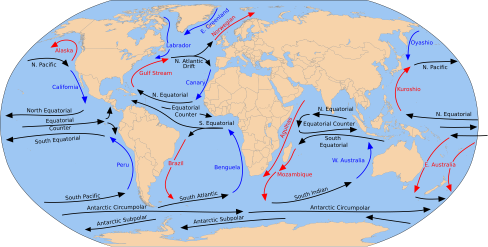
Depicts worldwide warm, neutral and cold directional currents.
Summary
[edit]
| Description |
English: A detailed Robinson-projection SVG map with grouping enabled to connect all non-contiguous parts of a country's territory for easy colouring. Smaller countries can also be represented by larger circles to show their data easier. A thorough description of use and other instructions relating to can be found on the instruction page. |
| Date | (UTC) |
| Source |
This file was derived from: Blank map of the world (Robinson projection) (10E).svg: This file was derived from: Corrientes-oceanicas.png: |
| Author |
|
_(10E).svg)

|
This SVG file contains embedded text that can be translated into your language, using any capable SVG editor, text editor or the SVG Translate tool. For more information see: About translating SVG files. |
This W3C-unspecified vector image was created with Inkscape .
Licensing
[edit]
I, the copyright holder of this work, hereby publish it under the following license:
| I, the copyright holder of this work, release this work into the public domain. This applies worldwide. In some countries this may not be legally possible; if so: I grant anyone the right to use this work for any purpose, without any conditions, unless such conditions are required by law. |
Original upload log
[edit]
This image is a derivative work of the following images:
- File:Blank map of the world (Robinson projection) (10E).svg licensed with PD-self
- 2011-05-16T04:18:31Z Milenioscuro 3100x1600 (2087786 Bytes) {{Information |Description={{en|1=A detailed Robinson-projection [[Help:SVG|SVG]] map with grouping enabled to connect all non-contiguous parts of a country's territory for easy colouring. Smaller countries can also be repres
Uploaded with derivativeFX
File history
Click on a date/time to view the file as it appeared at that time.
| Date/Time | Thumbnail | Dimensions | User | Comment | |
|---|---|---|---|---|---|
| current | 17:43, 30 July 2023 | | 976 × 493 (1.63 MB) | Matěj Grabovský (talk | contribs) | File uploaded using svgtranslate tool (https://svgtranslate.toolforge.org/). Added translation for cs. |
| 18:08, 15 December 2014 |  | 976 × 493 (1.67 MB) | RicHard-59 (talk | contribs) | Guls -> Gulf | |
| 14:20, 28 April 2014 |  | 976 × 493 (1.58 MB) | Moja~commonswiki (talk | contribs) | Correct "Oyashia" -> "Oyashio" | |
| 14:51, 17 August 2012 |  | 976 × 493 (1.66 MB) | Popadius (talk | contribs) | Reverted to version as of 14:42, 17 August 2012 | |
| 14:49, 17 August 2012 |  | 976 × 493 (1.1 MB) | Popadius (talk | contribs) | small fix | |
| 14:42, 17 August 2012 |  | 976 × 493 (1.66 MB) | Popadius (talk | contribs) | == {{int:filedesc}} == {{Information |Description={{en|1=A detailed Robinson-projection SVG map with grouping enabled to connect all non-contiguous parts of a country's territory for easy colouring. Smaller countries can also be represente... |
You cannot overwrite this file.
File usage on Commons
The following 6 pages use this file:
.svg)
.svg)
File usage on other wikis
The following other wikis use this file:
- Usage on ca.wikipedia.org
- Usage on cs.wikipedia.org
- Usage on de.wikipedia.org
- Usage on en.wikipedia.org
- Usage on eo.wikipedia.org
- Usage on es.wikipedia.org
- Usage on eu.wikipedia.org
- Ozeano Australa
- Golkoko itsaslasterra
- Humboldt itsaslasterra
- Agulhasko itsaslasterra
- Alaskako itsaslasterra
- Itsaslaster Zirkunpolar Antartikoa
- Antilletako itsaslasterra
- Benguelako itsaslasterra
- Brasilgo itsaslasterra
- Kaliforniako itsaslasterra
- Kanarietako itsaslasterra
- Floridako itsaslasterra
- Azoreetako itsaslasterra
- Karibeko itsaslasterra
- Cromwell itsaslasterra
- Ekialdeko Australiako itsaslasterra
- Groenlandiako ekialdeko itsaslasterra
- Madagaskarko ekialdeko itsaslasterra
- Malvinetako itsaslasterra
- Gineako itsaslasterra
- Irminger itsaslasterra
- Kuroshio itsaslasterra
- Oyashio itsaslasterra
- Labradorko itsaslasterra
- Leeuwingo itsaslasterra
- Lomonosov itsaslasterra
- Madagaskarko itsaslasterra
- Mindanaoko itsaslasterra
- Mozambikeko itsaslasterra
- Ipar Atlantikoko itsaslasterra
- Iparraldeko itsaslaster ekuatoriala
- Kontralaster Ekuatoriala
- Ipar Pazifikoko itsaslasterra
- Norvegiako itsaslasterra
View more global usage of this file.