File:Cornelis De Jode. Primae Partis Asiae accurata delineatio. (Unrecorded Variant, 1578).jpg
Jump to navigation
Jump to search
Size of this preview: 800 × 497 pixels. Other resolutions: 320 × 199 pixels | 640 × 397 pixels | 1,024 × 636 pixels | 1,280 × 795 pixels | 2,255 × 1,400 pixels.
Original file (2,255 × 1,400 pixels, file size: 4.5 MB, MIME type: image/jpeg)
Captions
Captions
Add a one-line explanation of what this file represents
Summary
[edit].jpg&action=edit§ion=1)
| Description |
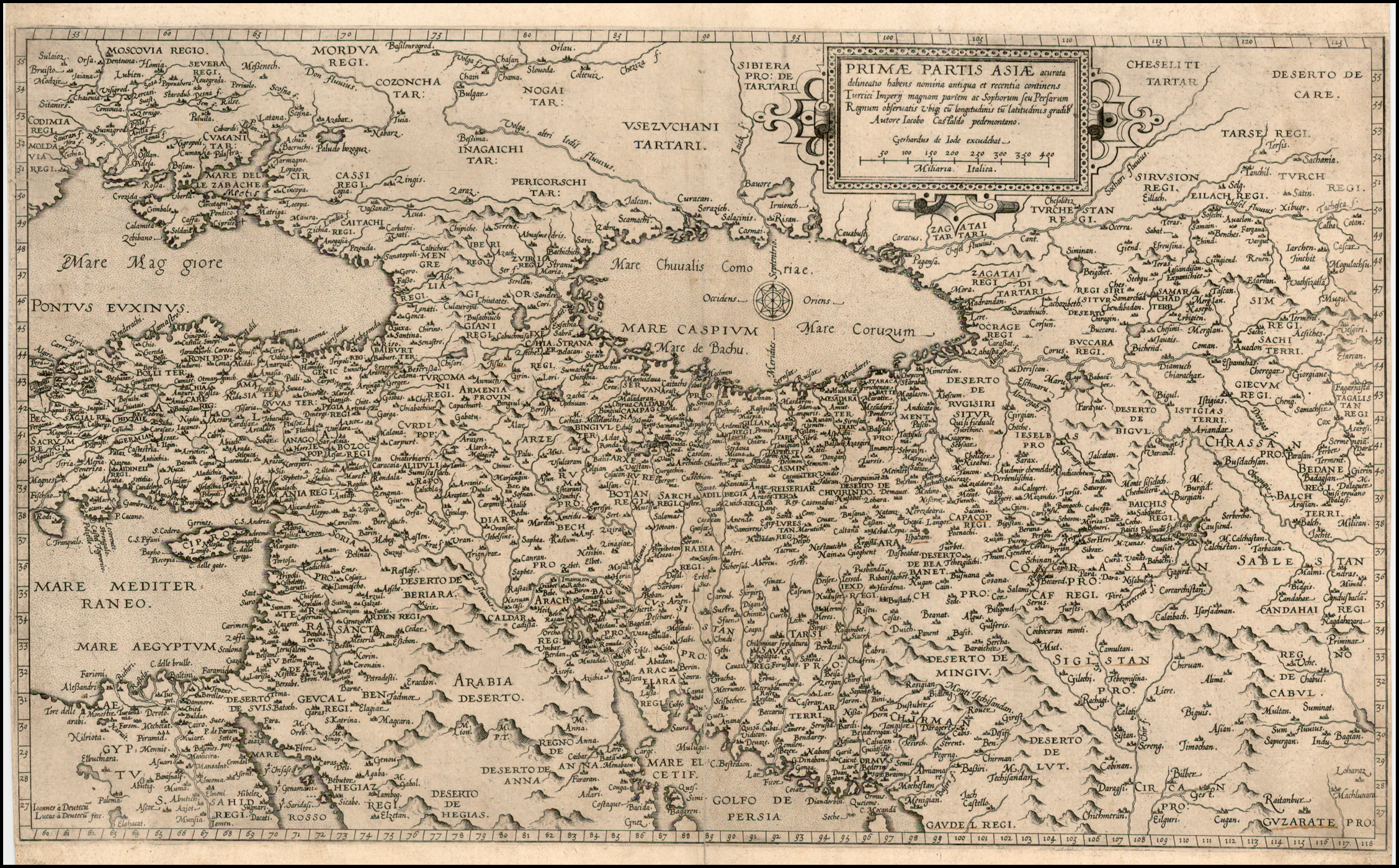
Cornelis De Jode: Primae Partis Asiae accurata delineatio… [shows Cyprus] [Unrecorded Variant!]. English: Unrecorded (?) variant edition of De Jode'shighly desireable map of the region, bounded by the Black Sea and Mediterranean in the West and Afganistan and Central Asia in the East. Cyprus is prominently shown in the Eastern Mediterranean.
The present example is identical to th 1579 edition of the map, but also includes the name "Meotis" in the Mare de le Zabache (Sea of Azov). Palus Meotis was the ancient name for Sea of Azof, with references to the name dating back to Strabo and before. De Jode's was a contemporary of Ortelius. His Speculum Orbis did not enjoy the same commercial success as Ortelius, making his maps very scarce and highly desireable. This map was engraved by the van Deutecum brothers and is based upon an earlier map by Gastaldi. |
| Date | circa 1578 |
| Source |
|
| Author | Cornelis de Jode |
Licensing
[edit].jpg&action=edit§ion=2)
|
This is a faithful photographic reproduction of a two-dimensional, public domain work of art. The work of art itself is in the public domain for the following reason:
The official position taken by the Wikimedia Foundation is that "faithful reproductions of two-dimensional public domain works of art are public domain".
This photographic reproduction is therefore also considered to be in the public domain in the United States. In other jurisdictions, re-use of this content may be restricted; see Reuse of PD-Art photographs for details. | ||||
File history
Click on a date/time to view the file as it appeared at that time.
| Date/Time | Thumbnail | Dimensions | User | Comment | |
|---|---|---|---|---|---|
| current | 18:56, 12 May 2011 | | 2,255 × 1,400 (4.5 MB) | Geagea (talk | contribs) | == {{int:filedesc}} == {{Information |Description={{fr|1=Cornelis De Jode: Primae Partis Asiae accurata delineatio… [shows Cyprus] [Unrecorded Variant!].<br /> Unrecorded (?) variant edition of De Jode'shighly desireable map of the region, bounded by t |
You cannot overwrite this file.
File usage on Commons
There are no pages that use this file.
.jpg&oldid=868403315)