Category:1578 maps
Jump to navigation
Jump to search
| ← · 1570 · 1571 · 1572 · 1573 · 1574 · 1575 · 1576 · 1577 · 1578 · 1579 · → |
Deutsch: Karten mit Bezug zum Jahr 1578
English: Maps related to the year 1578
Español: Mapas relativos al año 1578
Français : Cartes concernant l’an 1578
Русский: Карты 1578 года
Subcategories
This category has the following 4 subcategories, out of 4 total.
Media in category "1578 maps"
The following 19 files are in this category, out of 19 total.
-
 Americae Peruvi aque ita ut postremum detecta traditur recens delineatio RMG F0332.tiff 6,802 × 5,226; 101.7 MB
-
 Americae Peruvi aque ita ut postremum detecta traditur recens delineatio RMG L8556-001.jpg 1,280 × 1,005; 1.78 MB
-
 Americae Peruvi aque ita ut postremum detecta traditur recens delineatio RMG L8556-002.jpg 1,280 × 1,006; 1.33 MB
-
 Beschreibung Engellandts und Schottlandts.jpg 1,080 × 1,681; 207 KB
-
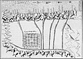 Caracas1578.jpg 769 × 543; 105 KB
-

-
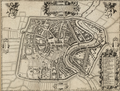
 First Map of Caracas, 1578.jpg 900 × 883; 186 KB
-
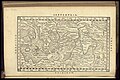
 Gauleptolemee1578.jpg 1,227 × 1,296; 270 KB
-
 Gerard De Jode, Universi Orbis seu Terreni Globi, 1578.png 4,282 × 2,942; 19.16 MB
-
 Guillaume Postel CHASDIA seu Australis terra.jpg 1,807 × 1,728; 422 KB
-
-
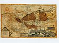 HOLY LAND Gerard de Jode. Speculum Orbis Terrarum.jpg 800 × 588; 269 KB
-
 Planodecaracas.gif 238 × 220; 15 KB
-
 Tho Thomasz 1578-Haarlem.png 750 × 570; 831 KB
-
 UBBasel Map 1578 Kartenslg AA 64.tif 11,976 × 9,838, 2 pages; 337.11 MB
-
 UBBasel Map 1578 Kartenslg AA 90 Grecia.tiff 11,993 × 9,744, 2 pages; 334.36 MB
-
 UBBasel Map Afrika 1578 Kartenslg AA 114.tif 13,102 × 8,954, 2 pages; 335.66 MB
-
 UBBasel Map Bethlehem Jerusalem Palästina 1578 Kartenslg AA 103.tif 13,076 × 8,978, 2 pages; 335.9 MB
-
 UBBasel Map Iberische Halbinsel 1578 Kartenslg AA 16a.tif 11,982 × 9,838, 2 pages; 337.28 MB


.jpg)


.jpg)


