File:Confirmed cases of COVID-19 in Ireland by county.svg
Jump to navigation
Jump to search

Size of this PNG preview of this SVG file: 552 × 600 pixels. Other resolutions: 221 × 240 pixels | 442 × 480 pixels | 707 × 768 pixels | 942 × 1,024 pixels | 1,884 × 2,048 pixels | 2,300 × 2,500 pixels.
Original file (SVG file, nominally 2,300 × 2,500 pixels, file size: 1.6 MB)
Captions
Captions
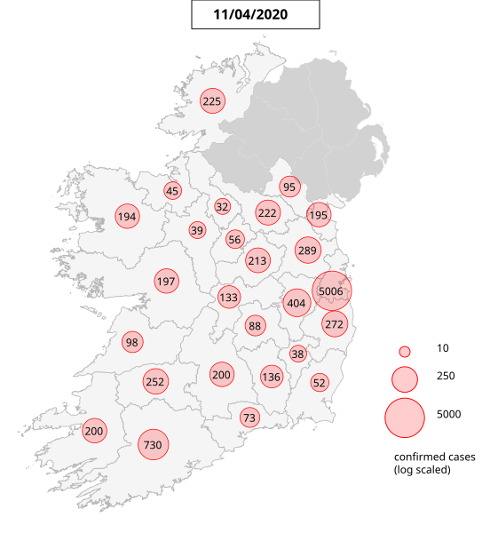
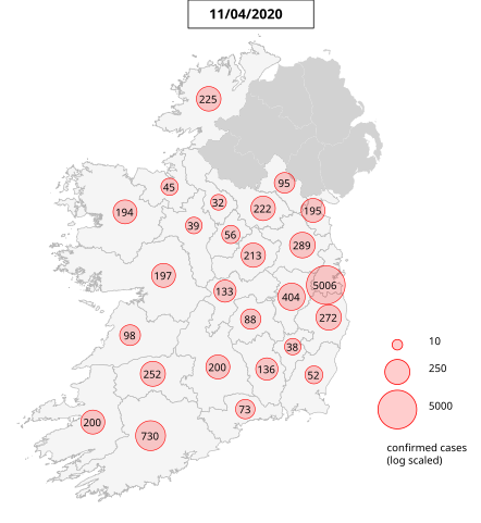
Confirmed cases of COVID-19 in Ireland by county
Summary
[edit]
| Description |
English: The map shows the number of COVID-19 cases per Irish county starting from 16-Mar-2020. The numbers of cases are sourced from the Irish Department of Health. The base map is processed from the counties boundary map by Ordnance Survey Ireland. |
| Date | |
| Source | Own work |
| Author | AnEddy11 |
Licensing
[edit]
I, the copyright holder of this work, hereby publish it under the following license:
This file is licensed under the Creative Commons Attribution-Share Alike 4.0 International license.
- You are free:
- to share – to copy, distribute and transmit the work
- to remix – to adapt the work
- Under the following conditions:
- attribution – You must give appropriate credit, provide a link to the license, and indicate if changes were made. You may do so in any reasonable manner, but not in any way that suggests the licensor endorses you or your use.
- share alike – If you remix, transform, or build upon the material, you must distribute your contributions under the same or compatible license as the original.
File history
Click on a date/time to view the file as it appeared at that time.
| Date/Time | Thumbnail | Dimensions | User | Comment | |
|---|---|---|---|---|---|
| current | 21:29, 13 April 2020 | | 2,300 × 2,500 (1.6 MB) | AnEddy11 (talk | contribs) | update 11/04/2020 data |
| 19:19, 12 April 2020 |  | 2,300 × 2,500 (1.6 MB) | AnEddy11 (talk | contribs) | update data of 10/04/2020 | |
| 12:16, 12 April 2020 |  | 2,300 × 2,500 (1.67 MB) | AnEddy11 (talk | contribs) | Uploaded own work with UploadWizard |
You cannot overwrite this file.
File usage on Commons
There are no pages that use this file.