File:Colton's new railroad & county map of the United States, the Canadas etc. LOC lva0000162.jpg
Jump to navigation
Jump to search

Size of this preview: 705 × 600 pixels. Other resolutions: 282 × 240 pixels | 564 × 480 pixels | 903 × 768 pixels | 1,204 × 1,024 pixels | 2,408 × 2,048 pixels | 12,311 × 10,470 pixels.
Original file (12,311 × 10,470 pixels, file size: 35.34 MB, MIME type: image/jpeg)
Captions
Captions
Add a one-line explanation of what this file represents
Summary
[edit]| Warning | The original file is very high-resolution. It might not load properly or could cause your browser to freeze when opened at full size. |
|---|
| Description |
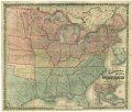
English: "Entered according to Act of Congress in the year 1861 by J.H. Colton." "Explanations" (i.e., legend) is pasted over the bottom margin. Map is colored to show "free, or non-slaveholding states" (pink), "border slave states" (yellow), and "seceded or confederate states" (green). Description derived from published bibliography. Insets: Colton's map of the United States showing the proposed railroad routes to the Pacific Ocean -- Southern part of Florida. This item is in the Map Collection of the Library of Virginia; please contact the Library's Archives Research Services department for more information. LC Civil War Maps (2nd ed.), 25.7 Available also through the Library of Congress web site as raster image. March 1962, C.R. Sanders, df; Oct. 2003, Map Cataloging Team. Civil War project no.: lva00162. Conservation: restored May 1965; Etherington Conservation Center, Oct. 2003. Digital image available: 40 x 30 in. Map accession no. 1983 (1964). Previously filed as: 730 .R15 1862. |
||
| Title | Colton's new railroad & county map of the United States, the Canadas &c. | ||
| Shelf ID | G3700 1862 .C64 | ||
| Date | |||
| Source | https://www.loc.gov/item/lva0000162/ | ||
| Author | Colton, J. H. (Joseph Hutchins) | ||
| Permission (Reusing this file) |
|
||
| Other versions |
|
||
| Location | United States | ||
| Part of | Military Battles And Campaigns · American Memory · Civil War Maps · Geography And Map Division | ||
| Subject | United States · Maps · Railroads · Civil War · History |

Licensing
[edit]
|
This is a faithful photographic reproduction of a two-dimensional, public domain work of art. The work of art itself is in the public domain for the following reason:
The official position taken by the Wikimedia Foundation is that "faithful reproductions of two-dimensional public domain works of art are public domain".
This photographic reproduction is therefore also considered to be in the public domain in the United States. In other jurisdictions, re-use of this content may be restricted; see Reuse of PD-Art photographs for details. | ||||
File history
Click on a date/time to view the file as it appeared at that time.
| Date/Time | Thumbnail | Dimensions | User | Comment | |
|---|---|---|---|---|---|
| current | 17:34, 3 June 2018 | | 12,311 × 10,470 (35.34 MB) | Fæ (talk | contribs) | LOC Maps https://www.loc.gov/item/lva0000162/ #3648 |
You cannot overwrite this file.
File usage on Commons
The following page uses this file: