File:Cliffe High Street - geograph.org.uk - 329303.jpg
Jump to navigation
Jump to search
No higher resolution available.
Cliffe_High_Street_-_geograph.org.uk_-_329303.jpg (640 × 479 pixels, file size: 110 KB, MIME type: image/jpeg)
Captions
Captions
Add a one-line explanation of what this file represents
Summary
[edit]
| Description |
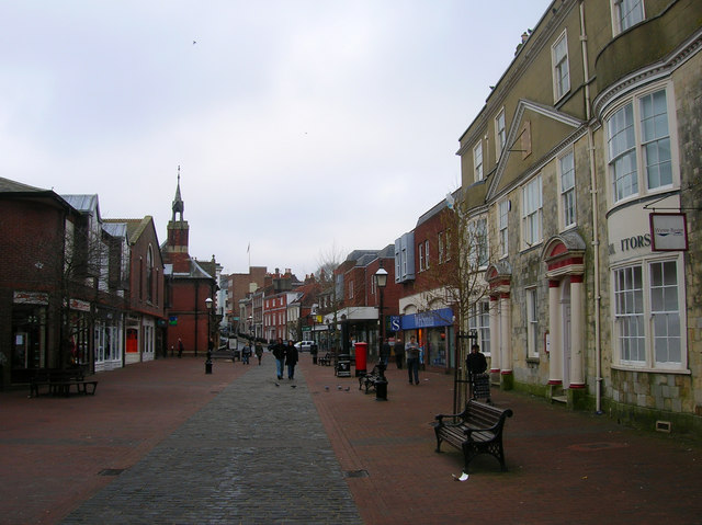
English: Cliffe High Street Pedestrianised in 1990 having once been the main A27 trunk road through the town until the building of Phoenix Causeway in the early 1970s. The view until 1968 would also have included an iron bridge that carried the Lewes to Uckfield line over the street, the position now occupied by WH Smiths on the right and the new buildings to the left. |
| Date | |
| Source | From geograph.org.uk |
| Author | Simon Carey |
| Attribution (required by the license) | Simon Carey / Cliffe High Street / |
| Camera location | | View this and other nearby images on: OpenStreetMap |
|---|
_heading:270.00&language=en)
| Object location | | View this and other nearby images on: OpenStreetMap |
|---|
_heading:270.00&language=en)
Licensing
[edit]

|
This image was taken from the Geograph project collection. See this photograph's page on the Geograph website for the photographer's contact details. The copyright on this image is owned by Simon Carey and is licensed for reuse under the Creative Commons Attribution-ShareAlike 2.0 license.
|
This file is licensed under the Creative Commons Attribution-Share Alike 2.0 Generic license.
Attribution: Simon Carey
- You are free:
- to share – to copy, distribute and transmit the work
- to remix – to adapt the work
- Under the following conditions:
- attribution – You must give appropriate credit, provide a link to the license, and indicate if changes were made. You may do so in any reasonable manner, but not in any way that suggests the licensor endorses you or your use.
- share alike – If you remix, transform, or build upon the material, you must distribute your contributions under the same or compatible license as the original.
File history
Click on a date/time to view the file as it appeared at that time.
| Date/Time | Thumbnail | Dimensions | User | Comment | |
|---|---|---|---|---|---|
| current | 18:23, 30 December 2010 | | 640 × 479 (110 KB) | GeographBot (talk | contribs) | == {{int:filedesc}} == {{Information |description={{en|1=Cliffe High Street Pedestrianised in 1990 having once been the main A27 trunk road through the town until the building of Phoenix Causeway in the early 1970s. The view until 1968 would also have inc |
You cannot overwrite this file.
File usage on Commons
There are no pages that use this file.