File:Civitates orbis terrarvm. LOC 2008627031-36 (detail2 Nieuwstad).jpg
Jump to navigation
Jump to search

Size of this preview: 800 × 570 pixels. Other resolutions: 320 × 228 pixels | 640 × 456 pixels | 1,024 × 729 pixels | 1,278 × 910 pixels.
Original file (1,278 × 910 pixels, file size: 449 KB, MIME type: image/jpeg)
Captions
Captions
Add a one-line explanation of what this file represents
Summary
[edit]| Description |
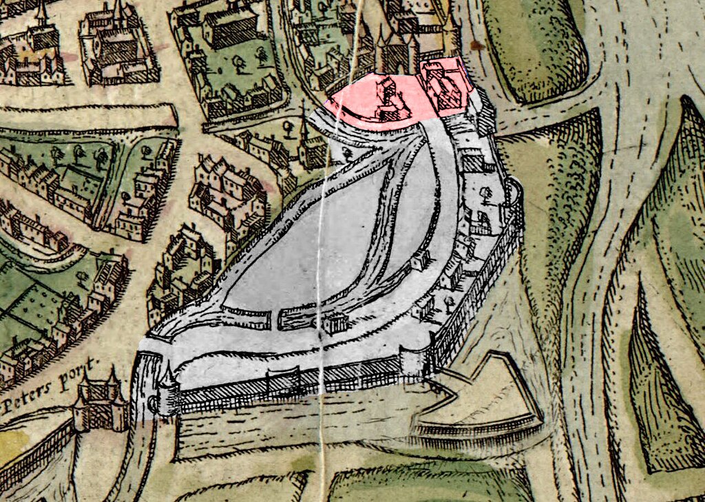
Nederlands: Detail plattegrond van Braun en Hogenberg (1575, heruitgegeven in 1612). In rood highlight: de kleine stadsuitbreiding van ca. 1456 bij de Helpoort. In wit highlight: de stadsuitbreiding Nieuwstad van ca. 1486 tussen de Sint-Pieterspoort (linksonder) en de Jekertoren (boven). Links van de Jekertoren de niet meer als stadspoort in gebruik zijnde Helpoort. De twee Nieuwstad-rondelen zijn nog als middeleeuwse waltorens ingetekend; bij De Vijf Koppen op provisorische wijze aangevuld met een bastion. Bij Haet ende Nijd ontbreekt dit.
English: "Privilegium Caesareae maiestatis, which occurs in each volume generally on the reverse of the title page, refers to Francis Hogenberg as the author's collaborator."--Phillips. Colophon of v. 1: Coloniae Agrippinae, apud Petrum à Brachel, sumptibus auctorum. Colophon of v. 6: Colonię Agrippinę, Antonius Hierat & Abrahamus Hoghenberg. Collaborators and artists whose works these maps were based on include George and Jacob Hoefnagel, Simon Novellanus, Jacob van Deventer, Heinrich Rantzau, etc. Available also through the Library of Congress Web site as a raster image. Includes indexes. Descriptive text on verso of plates. LC copy imperfect: Cumanae Sibyllae antrum (v. 3, no. 37), Venetiae (v. 5, no. 60), Neapolis (v. 5, no. 65), Pappa Ungar. pl. (v. 6, no. 35), and Praemislia Polon (v. 6, no. 52) wanting. |
||
| Title | Civitates orbis terrarvm. | ||
| Shelf ID | G1028 .B7 1612 G1028 .B7 1612 Copy 2 | ||
| Parent | https://www.loc.gov/resource/g3200m.gct00128b/ | ||
| Sheet title | Maestricht | ||
| Date | |||
| Source | https://www.loc.gov/item/2008627031/ | ||
| Author | Braun, Georg; Hogenberg, Franz; Brachel, P. Von; Hierat, Anton; Hogenberg, Abraham; Novellanus, Simon; Hoefnagel, Joris; Hoefnagel, Jacob; Deventer, Jacob Van; Rantzau, Henrik | ||
| Permission (Reusing this file) |
|
||
| Other versions |
|
||
| Location | Earth · Earth. · Germany | ||
| Part of | American Memory · Cities And Towns · Catalog · Geography And Map Division | ||
| Subject | Atlases · Aerial Views · Cities And Towns · Maps · Early Works To 1800 · Germany · Earth · World Atlases · Pictorial Works |


.jpg&action=edit§ion=1)
Licensing
[edit].jpg&action=edit§ion=2)
|
This is a faithful photographic reproduction of a two-dimensional, public domain work of art. The work of art itself is in the public domain for the following reason:
The official position taken by the Wikimedia Foundation is that "faithful reproductions of two-dimensional public domain works of art are public domain".
This photographic reproduction is therefore also considered to be in the public domain in the United States. In other jurisdictions, re-use of this content may be restricted; see Reuse of PD-Art photographs for details. | ||||
File history
Click on a date/time to view the file as it appeared at that time.
| Date/Time | Thumbnail | Dimensions | User | Comment | |
|---|---|---|---|---|---|
| current | 08:56, 1 March 2024 | | 1,278 × 910 (449 KB) | Kleon3 (talk | contribs) | red highlight addd |
| 14:29, 26 February 2024 |  | 1,278 × 910 (444 KB) | Kleon3 (talk | contribs) | correction white marking | |
| 21:38, 25 February 2024 |  | 1,278 × 910 (443 KB) | Kleon3 (talk | contribs) | Nieuwstad highlighted | |
| 20:47, 25 February 2024 |  | 1,278 × 910 (278 KB) | Kleon3 (talk | contribs) | File:Civitates orbis terrarvm. LOC 2008627031-36.jpg cropped 84 % horizontally, 85 % vertically using CropTool with precise mode. |
You cannot overwrite this file.
File usage on Commons
The following 3 pages use this file:
File usage on other wikis
The following other wikis use this file:
- Usage on nl.wikipedia.org
.jpg&oldid=861575012)