File:City of York Green Belt.svg

Original file (SVG file, nominally 1,714 × 1,047 pixels, file size: 1.56 MB)
Captions
Captions
Summary
[edit]
| Description |
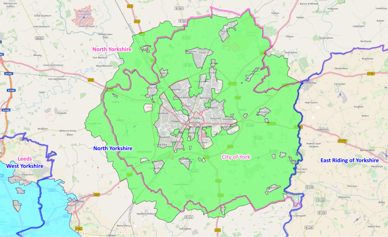
English: Green belt showing extents, districts and counties. Blue border - counties Red border - districts Green area - City of York green belt Blue area - South and West Yorkshire green belt |
| Date | |
| Source |
OpenMap and Department for Communities and Local Government. This is a derivative work of an Open Street Map, licensed under the Creative Commons Attribution-ShareAlike 4.0 licence. The underlying map is © OpenStreetMap contributors. http://www.openstreetmap.org. The boundaries for the overlays were sourced from the Department for Communities and Local Government and contains public sector information licensed under the Open Government Licence v3.0 |
| Author | The Equalizer (Added colour, lines, and text) |
| Camera location | | View this and other nearby images on: OpenStreetMap |
|---|
Licensing
[edit]
- You are free:
- to share – to copy, distribute and transmit the work
- to remix – to adapt the work
- Under the following conditions:
- attribution – You must give appropriate credit, provide a link to the license, and indicate if changes were made. You may do so in any reasonable manner, but not in any way that suggests the licensor endorses you or your use.
- share alike – If you remix, transform, or build upon the material, you must distribute your contributions under the same or compatible license as the original.
File history
Click on a date/time to view the file as it appeared at that time.
| Date/Time | Thumbnail | Dimensions | User | Comment | |
|---|---|---|---|---|---|
| current | 01:04, 23 November 2023 | | 1,714 × 1,047 (1.56 MB) | The Equalizer (talk | contribs) | Reverted to version as of 01:01, 23 November 2023 (UTC) |
| 01:03, 23 November 2023 |  | 1,714 × 1,047 (1.59 MB) | The Equalizer (talk | contribs) | Reverted to version as of 12:13, 21 December 2017 (UTC) | |
| 01:01, 23 November 2023 |  | 1,714 × 1,047 (1.56 MB) | The Equalizer (talk | contribs) | Removed abolished districts | |
| 21:18, 11 November 2023 |  | 1,714 × 1,047 (1.56 MB) | The Equalizer (talk | contribs) | Removed abolished districts | |
| 12:13, 21 December 2017 |  | 1,714 × 1,047 (1.59 MB) | The Equalizer (talk | contribs) | User created page with UploadWizard |
You cannot overwrite this file.
File usage on Commons
There are no pages that use this file.
File usage on other wikis
The following other wikis use this file:
- Usage on ckb.wikipedia.org
- Usage on en.wikipedia.org