File:Churchill river hudson basin map.png
Jump to navigation
Jump to search
Size of this preview: 800 × 525 pixels. Other resolutions: 320 × 210 pixels | 640 × 420 pixels | 1,024 × 672 pixels | 1,200 × 788 pixels.
Original file (1,200 × 788 pixels, file size: 1.6 MB, MIME type: image/png)
Captions
Captions
Add a one-line explanation of what this file represents
Summary
[edit]
| Description |
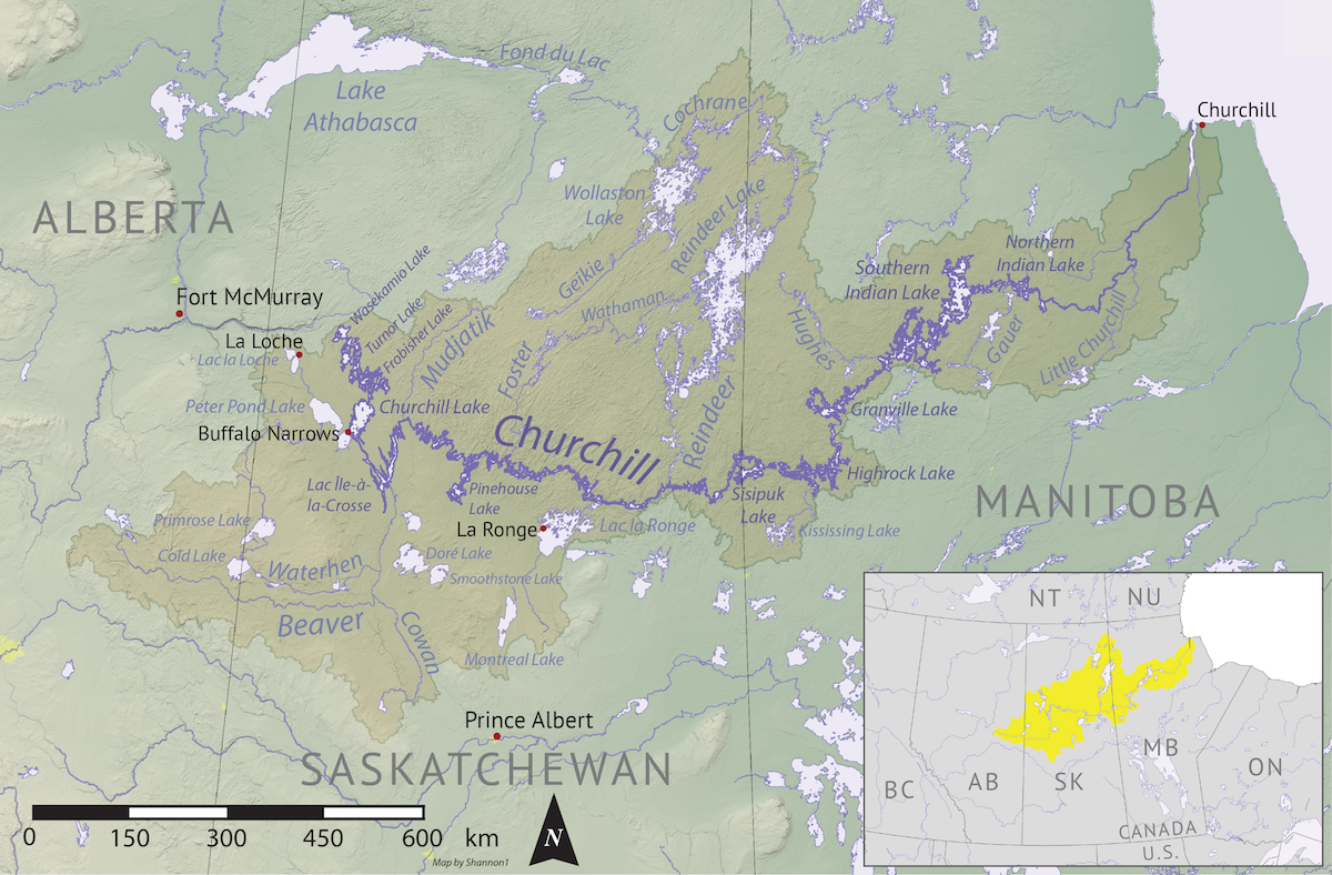
English: Map of the Churchill River (Hudson Bay) drainage basin. Data derived from NASA SRTM, Natural Resources Canada, US Geological Survey, Natural Earth, all public domain. |
| Date | |
| Source | Own work |
| Author | Shannon1 |
Licensing
[edit]
I, the copyright holder of this work, hereby publish it under the following licenses:

|
Permission is granted to copy, distribute and/or modify this document under the terms of the GNU Free Documentation License, Version 1.2 or any later version published by the Free Software Foundation; with no Invariant Sections, no Front-Cover Texts, and no Back-Cover Texts. A copy of the license is included in the section entitled GNU Free Documentation License. |
This file is licensed under the Creative Commons Attribution-Share Alike 4.0 International, 3.0 Unported, 2.5 Generic, 2.0 Generic and 1.0 Generic license.
- You are free:
- to share – to copy, distribute and transmit the work
- to remix – to adapt the work
- Under the following conditions:
- attribution – You must give appropriate credit, provide a link to the license, and indicate if changes were made. You may do so in any reasonable manner, but not in any way that suggests the licensor endorses you or your use.
- share alike – If you remix, transform, or build upon the material, you must distribute your contributions under the same or compatible license as the original.
You may select the license of your choice.
File history
Click on a date/time to view the file as it appeared at that time.
| Date/Time | Thumbnail | Dimensions | User | Comment | |
|---|---|---|---|---|---|
| current | 04:16, 7 November 2019 | | 1,200 × 788 (1.6 MB) | Shannon1 (talk | contribs) | {{Information |description ={{en|1=Map of the Churchill River (Hudson Bay) drainage basin. Data derived from NASA SRTM, Natural Resources Canada, US Geological Survey, Natural Earth, all public domain.}} |date =2019-11-03 |source =Own work |author =Shannon1 }} Category:Churchill River |
You cannot overwrite this file.
File usage on Commons
There are no pages that use this file.
File usage on other wikis
The following other wikis use this file:
- Usage on af.wikipedia.org
- Usage on da.wikipedia.org
- Usage on de.wikipedia.org
- Usage on en.wikipedia.org
- Churchill River (Hudson Bay)
- Beaver River (Canada)
- User:Shannon1/Maps
- Rapid River (Churchill River tributary)
- Montreal River (Saskatchewan)
- Whitefish River (Saskatchewan)
- Waterhen River (Saskatchewan)
- La Loche River (Saskatchewan)
- Geikie River (Saskatchewan)
- Reindeer River (Saskatchewan)
- Cochrane River (Canada)
- Nemei River
- Cold River (Saskatchewan)
- Martineau River
- Rusty Creek
- Meadow River (Saskatchewan)
- Nipekamew River
- Nipekamew Creek
- Big River (Saskatchewan)
- Cowan River
- Bow River (Saskatchewan)
- Waskesiu River
- Makwa River
- MacLennan River
- Smoothstone River
- Usage on fr.wikipedia.org
- Usage on ja.wikipedia.org
- Usage on pl.wikipedia.org
- Usage on sh.wikipedia.org
- Usage on uz.wikipedia.org
- Usage on xmf.wikipedia.org
- Usage on zh.wikipedia.org