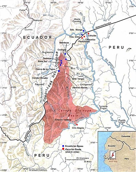
File:Cenepa river basin.jpg
From Wikimedia Commons, the free media repository
Jump to navigation
Jump to search

Size of this preview: 476 × 600 pixels. Other resolutions: 190 × 240 pixels | 381 × 480 pixels | 965 × 1,216 pixels.
Original file (965 × 1,216 pixels, file size: 900 KB, MIME type: image/jpeg)
File information
Structured data
Captions
Captions
Add a one-line explanation of what this file represents
Summary
[edit]| DescriptionCenepa river basin.jpg |
English: Peru-Ecuador (Area of Boundary Dispute). |
||
| Date | Unknown date | ||
| Source |
|
||
| Author | The University of Texas at Austin | ||
| Permission (Reusing this file) |
Stated as public domain. |
Licensing
[edit]| Public domainPublic domainfalsefalse |
This work is based on a work in the public domain. It has been digitally enhanced and/or modified. This derivative work has been (or is hereby) released into the public domain by its author, Andres C.. This applies worldwide.
In some countries this may not be legally possible; if so: |
Original upload log
[edit]The original description page was here. All following user names refer to en.wikipedia.
- 2010-10-30 14:30 Beao 965×1216× (921862 bytes)
- 2009-10-01 21:16 Andres C. 1000×1292× (876675 bytes) A retouched image of a map located online at the University of Texas Library - PCL Map Collection website. Stated as public domain: http://www.lib.utexas.edu/maps/americas/peru_ecuador_81.jpg "Courtesy of the University of Texas Libraries, The Universit
File history
Click on a date/time to view the file as it appeared at that time.
| Date/Time | Thumbnail | Dimensions | User | Comment | |
|---|---|---|---|---|---|
| current | 05:31, 15 September 2012 |  | 965 × 1,216 (900 KB) | OgreBot (talk | contribs) | (BOT): Uploading old version of file from en.wikipedia; originally uploaded on 2010-10-30 14:30:35 by Beao |
| 14:47, 10 August 2010 |  | 1,000 × 1,292 (856 KB) | File Upload Bot (Magnus Manske) (talk | contribs) | {{BotMoveToCommons|en.wikipedia|year={{subst:CURRENTYEAR}}|month={{subst:CURRENTMONTHNAME}}|day={{subst:CURRENTDAY}}}} {{Information |Description={{en|A retouched image of a map located online at the University of Texas Library - PCL Map Collection websi |
You cannot overwrite this file.
File usage on Commons
The following 2 pages use this file:
File usage on other wikis
The following other wikis use this file:
- Usage on az.wikipedia.org
- Usage on ca.wikipedia.org
- Usage on de.wikipedia.org
- Usage on en.wikipedia.org
- Usage on es.wikipedia.org
- Usage on et.wikipedia.org
- Usage on fi.wikipedia.org
- Usage on he.wikipedia.org
- Usage on id.wikipedia.org
- Usage on it.wikipedia.org
- Usage on ka.wikipedia.org
- Usage on pt.wikipedia.org
- Usage on qu.wikipedia.org
- Usage on ru.wikipedia.org
- Usage on sv.wikipedia.org
- Usage on uk.wikipedia.org
- Usage on www.wikidata.org
- Usage on zh.wikipedia.org
Metadata
This file contains additional information such as Exif metadata which may have been added by the digital camera, scanner, or software program used to create or digitize it. If the file has been modified from its original state, some details such as the timestamp may not fully reflect those of the original file. The timestamp is only as accurate as the clock in the camera, and it may be completely wrong.
| Horizontal resolution | 120 dpi |
|---|---|
| Vertical resolution | 120 dpi |
| Exif version | 2.1 |
| Supported Flashpix version | 1 |
| Color space | Uncalibrated |