File:Castlefield Canal Basin, Manchester - geograph.org.uk - 2154.jpg
Jump to navigation
Jump to search
No higher resolution available.
Castlefield_Canal_Basin,_Manchester_-_geograph.org.uk_-_2154.jpg (480 × 360 pixels, file size: 33 KB, MIME type: image/jpeg)
Captions
Captions
Add a one-line explanation of what this file represents
Summary
[edit]
| Description |
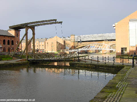
English: Castlefield Canal Basin, Manchester. Castlefield Basin was the terminus of the Bridgewater Canal and the wharves were at one time used for unloading coal and timber. It is now a fashionable venue, with pubs and canalside apartments alongside the canal heritage. |
| Date | |
| Source | From geograph.org.uk |
| Author | Martin Clark |
| Attribution (required by the license) | Martin Clark / Castlefield Canal Basin, Manchester / |
| Camera location | | View this and other nearby images on: OpenStreetMap |
|---|
_region:GB-EAW_heading:315.00&language=en)
| Object location | | View this and other nearby images on: OpenStreetMap |
|---|
_region:GB-EAW_heading:315.00&language=en)
Licensing
[edit]

|
This image was taken from the Geograph project collection. See this photograph's page on the Geograph website for the photographer's contact details. The copyright on this image is owned by Martin Clark and is licensed for reuse under the Creative Commons Attribution-ShareAlike 2.0 license.
|
This file is licensed under the Creative Commons Attribution-Share Alike 2.0 Generic license.
Attribution: Martin Clark
- You are free:
- to share – to copy, distribute and transmit the work
- to remix – to adapt the work
- Under the following conditions:
- attribution – You must give appropriate credit, provide a link to the license, and indicate if changes were made. You may do so in any reasonable manner, but not in any way that suggests the licensor endorses you or your use.
- share alike – If you remix, transform, or build upon the material, you must distribute your contributions under the same or compatible license as the original.
File history
Click on a date/time to view the file as it appeared at that time.
| Date/Time | Thumbnail | Dimensions | User | Comment | |
|---|---|---|---|---|---|
| current | 01:01, 30 January 2010 | | 480 × 360 (33 KB) | GeographBot (talk | contribs) | == {{int:filedesc}} == {{Information |description={{en|1=Castlefield Canal Basin, Manchester. Castlefield Basin was the terminus of the Bridgewater Canal and the wharves were at one time used for unloading coal and timber. It is now a fashionable venue, w |
You cannot overwrite this file.
File usage on Commons
There are no pages that use this file.
Metadata
Categories:
- Castlefield Basin, Manchester
- Bascule bridges in the United Kingdom
- Footbridges in the City of Manchester
- Railway viaducts in the City of Manchester
- Towpaths in Greater Manchester
- Street lights in the City of Manchester
- Railings in Greater Manchester
- Single-leaf bascule bridges
- Merchants' Bridge, Manchester