Category:Images by Martin Clark
Jump to navigation
Jump to search

Media in category "Images by Martin Clark"
The following 200 files are in this category, out of 321 total.
(previous page) (next page)-
 "Boston Stump" - geograph.org.uk - 3978.jpg 512 × 438; 35 KB
-

-
 Albert Dock, Liverpool - geograph.org.uk - 4623.jpg 640 × 397; 41 KB
-
 Albert Dock, Liverpool - geograph.org.uk - 4853.jpg 640 × 418; 41 KB
-
 Alrewas, Staffordshire - geograph.org.uk - 3843.jpg 640 × 390; 39 KB
-
 Ancoats Locks, Ashton Canal - geograph.org.uk - 2151.jpg 480 × 352; 33 KB
-
 Ashton Canal from Edge Lane Bridge - geograph.org.uk - 2146.jpg 480 × 360; 36 KB
-
 Ashton Market, Ashton under Lyne - geograph.org.uk - 2097.jpg 480 × 322; 33 KB
-

-
 Audenshaw - Ashton Canal.jpg 480 × 360; 34 KB
-
 Audley, Blackburn - geograph.org.uk - 4162.jpg 600 × 412; 37 KB
-
 Austerlands - geograph.org.uk - 5536.jpg 640 × 397; 38 KB
-
 Avoncliff Aqueduct, Wiltshire - geograph.org.uk - 3711.jpg 600 × 449; 40 KB
-
 Avoncliffaqueduct.jpg 640 × 414; 40 KB
-
 AxbridgeSquare.jpg 480 × 336; 35 KB
-
 Banbury 1.jpg 600 × 400; 39 KB
-
 Barnsley Canal near Carlton - geograph.org.uk - 184715.jpg 640 × 480; 67 KB
-
 Barrowford Locks - geograph.org.uk - 4140.jpg 640 × 394; 38 KB
-
 Barrowford Locks - geograph.org.uk - 4292.jpg 640 × 387; 41 KB
-
 Bathampton - geograph.org.uk - 3707.jpg 640 × 380; 41 KB
-
 Bingley - Five-Rise Locks.jpg 640 × 425; 44 KB
-
 Bishop Park, Grains Bar - geograph.org.uk - 2324.jpg 512 × 324; 27 KB
-
 Blackburn Locks - geograph.org.uk - 4151.jpg 640 × 404; 42 KB
-
 Blackburn Locks - geograph.org.uk - 4157.jpg 600 × 421; 46 KB
-
 Blakeley Reservoir - geograph.org.uk - 2289.jpg 480 × 360; 34 KB
-
 Bleak Hey Nook - geograph.org.uk - 5213.jpg 640 × 375; 40 KB
-
 Bradford-on-Avon - geograph.org.uk - 2488.jpg 480 × 360; 34 KB
-
 Bradshaw, near Holmfirth - geograph.org.uk - 2262.jpg 480 × 333; 33 KB
-
 Bramwith Swing Bridge - geograph.org.uk - 5209.jpg 640 × 359; 40 KB
-
 Braunston Canal Junction - geograph.org.uk - 3775.jpg 600 × 375; 37 KB
-
 Braunston Locks - geograph.org.uk - 3773.jpg 600 × 415; 38 KB
-
 Brearley Lock - geograph.org.uk - 6839.jpg 640 × 400; 43 KB
-
 Broadbottom Bridge, Mytholmroyd - geograph.org.uk - 5344.jpg 640 × 371; 39 KB
-
 Broadhead Farm, Castleshaw - geograph.org.uk - 332341.jpg 640 × 480; 149 KB
-
 Broadoak Hotel, Ashton under Lyne - geograph.org.uk - 2591.jpg 512 × 300; 32 KB
-
 Brown Knoll from Kinder - geograph.org.uk - 2383.jpg 512 × 292; 32 KB
-
 Bugsworth Basin, Peak Forest Canal - geograph.org.uk - 2065.jpg 512 × 327; 29 KB
-
 Bunbury Locks.jpg 600 × 396; 39 KB
-
 Burnham on Sea - geograph.org.uk - 2445.jpg 480 × 257; 28 KB
-
 Burnley Embankment - geograph.org.uk - 4197.jpg 600 × 360; 32 KB
-
 Buxton Lane Swing Bridge, Droylsden - geograph.org.uk - 2148.jpg 480 × 360; 44 KB
-
 Caen Hill Locks, Devizes - geograph.org.uk - 3609.jpg 640 × 407; 42 KB
-
 Caen Hill Locks, Devizes - geograph.org.uk - 3610.jpg 640 × 398; 40 KB
-
 Canal Junction, Wigan - geograph.org.uk - 4181.jpg 640 × 365; 38 KB
-
 Canal Street, Manchester - geograph.org.uk - 2153.jpg 480 × 360; 41 KB
-
 Canal Terrace, Wigan - geograph.org.uk - 4185.jpg 640 × 382; 41 KB
-
 Carr Lane, Slaithwaite - geograph.org.uk - 57425.jpg 640 × 407; 67 KB
-
 Carr Lane, Slaithwaite - geograph.org.uk - 57429.jpg 640 × 418; 72 KB
-
 Carrbrook, Stalybridge - geograph.org.uk - 2576.jpg 512 × 290; 35 KB
-
 Castle Hill, Huddersfield - geograph.org.uk - 2473.jpg 480 × 296; 31 KB
-
 Castle Lane, Micklehurst, Mossley - geograph.org.uk - 2574.jpg 512 × 339; 35 KB
-
 Castlefield Canal Basin, Manchester - geograph.org.uk - 2154.jpg 480 × 360; 33 KB
-
 Castleshaw Top Reservoir - geograph.org.uk - 332250.jpg 640 × 480; 129 KB
-
 Castleshaw Top Reservoir and Standedge - geograph.org.uk - 332329.jpg 640 × 480; 126 KB
-
 Centenary Bridge, Manchester Ship Canal - geograph.org.uk - 2747.jpg 512 × 360; 33 KB
-
 Cheddargorge.jpg 480 × 360; 34 KB
-
 Cheddleton Station - geograph.org.uk - 3898.jpg 600 × 430; 42 KB
-
 Chew Valley from Blindstones Moss - geograph.org.uk - 2356.jpg 512 × 346; 38 KB
-
 Chirk Aqueduct and Tunnel - geograph.org.uk - 3758.jpg 600 × 398; 41 KB
-

-
 Chrome hill.jpg 512 × 325; 35 KB
-

-

-
 Clachnaharry Sea Lock - geograph.org.uk - 4265.jpg 640 × 398; 41 KB
-
 Clifton Suspension Bridge - geograph.org.uk - 3166.jpg 640 × 414; 41 KB
-
 Clifton Suspension Bridge from Hotwells - geograph.org.uk - 3179.jpg 640 × 360; 40 KB
-
 Clock, Market Street, Ashton under Lyne - geograph.org.uk - 2094.jpg 480 × 359; 40 KB
-
 Cockbrook, Ashton under Lyne - geograph.org.uk - 2589.jpg 512 × 323; 35 KB
-
 Compton Bishop Church - geograph.org.uk - 4655.jpg 524 × 357; 62 KB
-
 Consall Forge - geograph.org.uk - 3918.jpg 600 × 424; 40 KB
-
 Consall Forge Station - geograph.org.uk - 3929.jpg 600 × 391; 40 KB
-

-
 Cropredy Lock, Oxfordshire - geograph.org.uk - 3357.jpg 512 × 384; 38 KB
-
 Crowden Clough, Kinder Plateau - geograph.org.uk - 2376.jpg 512 × 384; 40 KB
-
 Curzon Park Chester2.jpg 640 × 421; 51 KB
-
 Daisyfield Mill, Blackburn - geograph.org.uk - 4168.jpg 640 × 391; 44 KB
-
 Dearne and Dove Canal near Stairfoot - geograph.org.uk - 183119.jpg 640 × 480; 47 KB
-
 Dee Locks Branch, Chester - geograph.org.uk - 3961.jpg 600 × 389; 39 KB
-
 Denby Dale - geograph.org.uk - 6406.jpg 640 × 363; 41 KB
-
-
 Diggle Valley - geograph.org.uk - 5214.jpg 640 × 380; 39 KB
-
 Dovestones Reservoir - geograph.org.uk - 6841.jpg 640 × 391; 41 KB
-
 Dovestones Reservoir from Chew Hurdles - geograph.org.uk - 2354.jpg 512 × 358; 34 KB
-
 Dudley Canal at Windmill End - geograph.org.uk - 3078.jpg 512 × 333; 53 KB
-
 Dundas Aqueduct - geograph.org.uk - 3713.jpg 600 × 450; 41 KB
-
 Eanam Wharf, Blackburn - geograph.org.uk - 4164.jpg 640 × 374; 40 KB
-
 Edale Church - geograph.org.uk - 5308.jpg 640 × 401; 44 KB
-
 Ellesmere Canal Basin, Shropshire - geograph.org.uk - 4102.jpg 640 × 374; 38 KB
-
 Ellesmere Port Boat Museum - geograph.org.uk - 4615.jpg 640 × 400; 44 KB
-
 Elsecar - geograph.org.uk - 6943.jpg 640 × 381; 40 KB
-
 Ely Cathedral from River Great Ouse - geograph.org.uk - 3968.jpg 640 × 383; 40 KB
-

-
 Fairfield Locks, Droylsden - geograph.org.uk - 2145.jpg 480 × 360; 37 KB
-
 Fall Ing Lock - geograph.org.uk - 184728.jpg 640 × 471; 82 KB
-

-
 Foulridge Tunnel - geograph.org.uk - 4134.jpg 600 × 441; 74 KB
-
 Foulridge Tunnel - geograph.org.uk - 4136.jpg 600 × 425; 83 KB
-
 Foxton Locks, Leicestershire - geograph.org.uk - 3761.jpg 600 × 389; 38 KB
-
 Foxton Locks, Leicestershire - geograph.org.uk - 3763.jpg 600 × 398; 40 KB
-
 Fradley Canal Junction - geograph.org.uk - 3862.jpg 600 × 400; 39 KB
-
 Frankton Locks - geograph.org.uk - 4107.jpg 600 × 422; 39 KB
-
 Froghall Station - geograph.org.uk - 3904.jpg 600 × 430; 42 KB
-
 Froghall Tunnel - geograph.org.uk - 3908.jpg 600 × 413; 39 KB
-
 Gannow Tunnel - geograph.org.uk - 4207.jpg 600 × 407; 37 KB
-
 Gauxholme - geograph.org.uk - 5328.jpg 640 × 400; 43 KB
-
 Golcar Aqueduct, Huddersfield Canal - geograph.org.uk - 164592.jpg 640 × 480; 108 KB
-
 Golcar Aqueduct, Huddersfield Canal - geograph.org.uk - 2213.jpg 480 × 360; 38 KB
-
 Gordale Scar - geograph.org.uk - 2484.jpg 330 × 400; 31 KB
-
 Granary Wharf, Leeds - geograph.org.uk - 4132.jpg 640 × 407; 40 KB
-
 Greenberfield - geograph.org.uk - 4137.jpg 627 × 445; 68 KB
-
 Grindley Brook Locks.jpg 600 × 427; 41 KB
-
 Grindslow Knoll, Peak District - geograph.org.uk - 2368.jpg 512 × 343; 38 KB
-
 Guide Bridge, Ashton Canal - geograph.org.uk - 2142.jpg 480 × 360; 40 KB
-
 Halfpenny Bridge, Lechlade.jpg 640 × 400; 39 KB
-
 Hartshead Estate, Ashton under Lyne - geograph.org.uk - 2593.jpg 512 × 325; 35 KB
-
 Hartshead Pike, Ashton under Lyne - geograph.org.uk - 2055.jpg 512 × 384; 36 KB
-
 Hazelhurst Aqueduct - geograph.org.uk - 3869.jpg 600 × 413; 38 KB
-
 Hazelhurst Locks - geograph.org.uk - 3867.jpg 600 × 446; 41 KB
-
 Hazelhurst, Ashton under Lyne - geograph.org.uk - 2595.jpg 512 × 324; 34 KB
-
 Hebden Bridge - geograph.org.uk - 5342.jpg 640 × 400; 44 KB
-
 High Marnham Power Station, River Trent - geograph.org.uk - 3112.jpg 640 × 399; 40 KB
-
 Hirst Mill Swing Bridge - geograph.org.uk - 134089.jpg 640 × 480; 67 KB
-
 Holcombe Swing Bridge - geograph.org.uk - 3708.jpg 640 × 398; 40 KB
-
-
 Huddersfield Broad Canal - geograph.org.uk - 2225.jpg 480 × 360; 32 KB
-
 Huddersfield Broad Canal - geograph.org.uk - 2229.jpg 480 × 360; 32 KB
-
 Huddersfield Broad Canal - geograph.org.uk - 2231.jpg 480 × 360; 36 KB
-
 Huddersfield Broad Canal - geograph.org.uk - 2233.jpg 480 × 358; 34 KB
-
 Huddersfield Broad Canal - geograph.org.uk - 2236.jpg 480 × 360; 32 KB
-
 Huddersfield Broad Canal at Deighton - geograph.org.uk - 2249.jpg 480 × 360; 31 KB
-
 Huddersfield Canal at Booth, Marsden - geograph.org.uk - 2207.jpg 480 × 360; 31 KB
-

-
 Huddersfield Canal at Linthwaite - geograph.org.uk - 2209.jpg 480 × 349; 30 KB
-
 Huddersfield Canal at Marsden - geograph.org.uk - 2180.jpg 480 × 342; 36 KB
-
 Huddersfield Canal at Milnsbridge - geograph.org.uk - 2214.jpg 480 × 357; 40 KB
-
 Huddersfield Canal at Slaithwaite - geograph.org.uk - 2191.jpg 480 × 360; 36 KB
-
 Huddersfield Canal at West Slaithwaite - geograph.org.uk - 2204.jpg 480 × 360; 36 KB
-
 Huddersfield Canal east of Milnsbridge - geograph.org.uk - 2216.jpg 480 × 360; 39 KB
-
 Huddersfield Canal in Slaithwaite - geograph.org.uk - 2200.jpg 480 × 360; 39 KB
-
 Huddersfield Canal in Stalybridge - geograph.org.uk - 2164.jpg 512 × 336; 42 KB
-
 Huddersfield Canal near Linthwaite - geograph.org.uk - 2210.jpg 480 × 360; 39 KB
-
 Huddersfield Road, Standedge - geograph.org.uk - 5212.jpg 640 × 357; 37 KB
-
 Hurleston Locks, Llangollen Canal - geograph.org.uk - 4117.jpg 600 × 406; 39 KB
-
 Inglesham Round House - geograph.org.uk - 3260.jpg 640 × 410; 41 KB
-
 Keadby Bridge - geograph.org.uk - 3126.jpg 640 × 323; 37 KB
-
 Keadby Swing Bridge - geograph.org.uk - 5196.jpg 640 × 387; 40 KB
-
 Kennet and Avon Canal near Seend Cleeve - geograph.org.uk - 3716.jpg 600 × 420; 40 KB
-

-
 Knowl Top, Saddleworth - geograph.org.uk - 5216.jpg 600 × 406; 41 KB
-
 Latchford Lock, Manchester Ship Canal - geograph.org.uk - 3023.jpg 512 × 350; 37 KB
-

-

-

-

-
 Leeds and Liverpool Canal near Thackley - geograph.org.uk - 134077.jpg 640 × 480; 117 KB
-

-
 Leek Tunnel - geograph.org.uk - 3934.jpg 600 × 418; 37 KB
-

-
 Lincoln Cathedral from River Witham - geograph.org.uk - 3975.jpg 640 × 375; 41 KB
-
 Liverpool Waterfront - geograph.org.uk - 4854.jpg 640 × 387; 40 KB
-
 Llangollen Canal at Ellesmere - geograph.org.uk - 4100.jpg 640 × 370; 36 KB
-
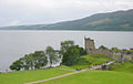 Loch Ness and Urquhart Castle - geograph.org.uk - 4629.jpg 640 × 406; 43 KB
-

-

-
 Lock 9w, Huddersfield Canal - geograph.org.uk - 2171.jpg 480 × 360; 37 KB
-

-

-

-
 Low Bradley, near Skipton - geograph.org.uk - 3245.jpg 640 × 363; 45 KB
-
 Luddenden Foot - geograph.org.uk - 6835.jpg 640 × 387; 40 KB
-
 Luddenden Foot - geograph.org.uk - 6836.jpg 640 × 371; 41 KB
-
 Manchester Bolton and Bury canal Nob End.jpg 640 × 394; 40 KB
-

-
 Manchester Ship Canal at Runcorn - geograph.org.uk - 3025.jpg 640 × 329; 34 KB
-
 Marple Aqueduct 2003.jpg 512 × 384; 45 KB
-
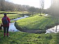 Meander in River Medlock - geograph.org.uk - 2291.jpg 480 × 360; 37 KB
-
 Medlock Valley Way, Strine Dale - geograph.org.uk - 2312.jpg 480 × 360; 35 KB
-
 Millbrook Church, Stalybridge - geograph.org.uk - 2582.jpg 480 × 366; 33 KB
-
 Mode Wheel Lock, Manchester Ship Canal - geograph.org.uk - 2748.jpg 512 × 279; 34 KB
-

-
 Mossley.jpg 512 × 372; 114 KB
-
 Motorway Viaducts near Burnley - geograph.org.uk - 4205.jpg 600 × 381; 33 KB
-
 Muirtown Basin - geograph.org.uk - 7312.jpg 640 × 393; 41 KB
-
 Muirtown Locks - geograph.org.uk - 7313.jpg 640 × 416; 50 KB
-
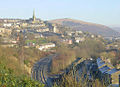
 Mumps - geograph.org.uk - 5003.jpg 640 × 414; 42 KB
-
 Napton Locks, Warwickshire - geograph.org.uk - 3353.jpg 640 × 408; 40 KB
-
 Southern Oxford Canal at Napton Holt - geograph.org.uk - 3355.jpg 640 × 377; 40 KB
-
 Narrowboats at Trent Lock - geograph.org.uk - 3824.jpg 640 × 365; 40 KB
-
 Newark Lock and Castle - geograph.org.uk - 3109.jpg 640 × 418; 40 KB
-
 Oddies Swing Bridge, near Baildon - geograph.org.uk - 134082.jpg 640 × 469; 54 KB
-
 Old Bank, Slaithwaite - geograph.org.uk - 2198.jpg 480 × 342; 38 KB
-
 Old Lock, Rochdale Canal - geograph.org.uk - 5292.jpg 640 × 394; 40 KB
-

-
 Oldham - geograph.org.uk - 5002.jpg 640 × 382; 38 KB
-
 Ollerbrook Clough - geograph.org.uk - 5305.jpg 600 × 414; 43 KB
-
 On the Kirklees Way, near Holmfirth - geograph.org.uk - 2269.jpg 480 × 360; 35 KB
-
 Ontario Basin, Salford Quays - geograph.org.uk - 2162.jpg 480 × 360; 34 KB
-
 Osney Lock, River Thames, Oxford - geograph.org.uk - 3257.jpg 640 × 386; 37 KB
-
 Ox Hey Lane, Denshaw - geograph.org.uk - 332286.jpg 640 × 480; 151 KB
-
 Penketh - The Ferry Tavern.jpg 640 × 364; 39 KB


