File:Carte du département de la Meurthe 1790-1793.tiff
Jump to navigation
Jump to search

Size of this JPG preview of this TIF file: 734 × 600 pixels. Other resolutions: 294 × 240 pixels | 588 × 480 pixels | 940 × 768 pixels | 1,253 × 1,024 pixels | 2,507 × 2,048 pixels | 5,762 × 4,708 pixels.
Original file (5,762 × 4,708 pixels, file size: 77.65 MB, MIME type: image/tiff)
Captions
Captions
Add a one-line explanation of what this file represents
Summary
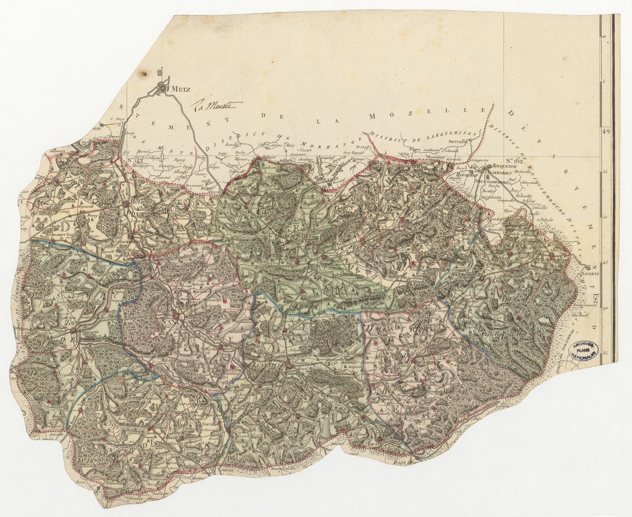
[edit]| Carte du département de la Meurthe
( |
|||||||||||||||||||||
|---|---|---|---|---|---|---|---|---|---|---|---|---|---|---|---|---|---|---|---|---|---|
| Author |
François d’Houdan (1748-1828) ; Pierre Dumez (1757-1794) ; Pierre-Gilles Chanlaire (1758-1817) |
||||||||||||||||||||
| Title |
Carte du département de la Meurthe |
||||||||||||||||||||
| Description |
Carte du département de la Meurthe. Limites des districts et cantons, chefs-lieux ; nom du département ajouté à l'encre au recto et au verso. Echelle : 1/267 000. Carte faisant partie de l'Atlas national de France. Voir en ligne les procès-verbaux de division de la France. Voir la notice d'inventaire en ligne |
||||||||||||||||||||
| Date | between 1790 and 1793 | ||||||||||||||||||||
| Medium | Gravure + couleur, tracé en couleur | ||||||||||||||||||||
| Dimensions | 38 x 47 cm | ||||||||||||||||||||
| Collection |
|
||||||||||||||||||||
| References | Archives nationales (France), CP/NN//267/1 | ||||||||||||||||||||
| Source/Photographer |
|
||||||||||||||||||||
| Permission (Reusing this file) |
|
||||||||||||||||||||

Licensing
[edit]|
This work is in the public domain in its country of origin and other countries and areas where the copyright term is the author's life plus 100 years or fewer. | |
| This file has been identified as being free of known restrictions under copyright law, including all related and neighboring rights. | |
File history
Click on a date/time to view the file as it appeared at that time.
| Date/Time | Thumbnail | Dimensions | User | Comment | |
|---|---|---|---|---|---|
| current | 13:35, 17 December 2022 |  | 5,762 × 4,708 (77.65 MB) | Archives nationales MCP (talk | contribs) | pattypan 22.03 |
You cannot overwrite this file.
File usage on Commons
The following 2 pages use this file:
File usage on other wikis
The following other wikis use this file:
- Usage on fr.wikipedia.org
Metadata
Categories:
- Media contributed by the Archives Nationales (France)/16
- Maps in the Archives Nationales (France)
- 18th-century documents in the Archives nationales (France)
- Meurthe (department)
- Meurthe-et-Moselle (département) in Archives nationales (France)
- Cartes de départements découpées dans l'Atlas national de France (1790)