File:Carte Guerre de Sept Ans Europe.PNG
Original file (884 × 643 pixels, file size: 77 KB, MIME type: image/png)
Captions
Captions
Incorrect Information
[edit]
- After the Russian-Swedisch war of 1741–1743 Finnland was russian in the East, up to the river Kymijoki, and Swedish in the western part. --El bes (talk) 21:02, 10 August 2008 (UTC)
An even bigger error here is that the UK, formed in 1707, is listed as England. Also, Ireland didn't join the Union until 1801, and at the time was still a kingdom in its own right.
Poland should be shown as the Polish-Lithuanian Commonwealth.
Austro-Ottoman borders shown here are actually from 1718-1739 period, between Treaty of Požarevac and Treaty of Belgrade

|
This historical map image could be re-created using vector graphics as an SVG file. This has several advantages; see Commons:Media for cleanup for more information. If an SVG form of this image is available, please upload it and afterwards replace this template with
{{vector version available|new image name}}.
It is recommended to name the SVG file “Carte Guerre de Sept Ans Europe.svg”—then the template Vector version available (or Vva) does not need the new image name parameter. |
Summary
[edit]
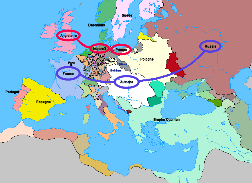
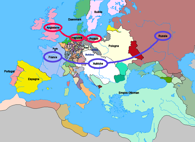
Carte de l'Europe et des alliances à la veille de la guerre de Sept Ans (1757)
Licensing
[edit]
Upload: Wordelle
| I, the copyright holder of this work, release this work into the public domain. This applies worldwide. In some countries this may not be legally possible; if so: I grant anyone the right to use this work for any purpose, without any conditions, unless such conditions are required by law. |
No machine-readable source provided. Own work assumed (based on copyright claims).
File history
Click on a date/time to view the file as it appeared at that time.
| Date/Time | Thumbnail | Dimensions | User | Comment | |
|---|---|---|---|---|---|
| current | 21:25, 1 January 2012 | | 884 × 643 (77 KB) | Artemis Dread (talk | contribs) | Republic of Ragusa |
| 22:19, 24 December 2011 |  | 884 × 643 (77 KB) | Artemis Dread (talk | contribs) | Prince-Bishopric of Montenegro | |
| 10:58, 18 September 2011 |  | 884 × 643 (77 KB) | Artemis Dread (talk | contribs) | Kingdom of Imereti and Kingdom of Kartli-Kakheti, minor changes | |
| 14:31, 17 September 2011 |  | 884 × 643 (76 KB) | Artemis Dread (talk | contribs) | Finland | |
| 13:15, 17 September 2011 |  | 884 × 643 (76 KB) | Artemis Dread (talk | contribs) | minor changes | |
| 12:17, 17 September 2011 |  | 884 × 643 (76 KB) | Artemis Dread (talk | contribs) | Duchy of Courland and Semigallia | |
| 11:13, 17 September 2011 |  | 884 × 643 (76 KB) | Artemis Dread (talk | contribs) | Cossack Hetmanate | |
| 10:36, 17 September 2011 |  | 884 × 643 (76 KB) | Artemis Dread (talk | contribs) | vassals of the Ottoman Empire | |
| 09:30, 18 October 2006 |  | 884 × 643 (72 KB) | Wordelle (talk | contribs) | Carte de l'Europe et des alliances à la veille de la guerre de Sept Ans (1757) |
You cannot overwrite this file.
File usage on Commons
The following page uses this file:
File usage on other wikis
The following other wikis use this file:
- Usage on af.wikipedia.org
- Usage on ar.wikipedia.org
- Usage on az.wikipedia.org
- Usage on bg.wikipedia.org
- Usage on br.wikipedia.org
- Usage on ca.wikipedia.org
- Usage on cs.wikipedia.org
- Usage on de.wikipedia.org
- Usage on el.wikipedia.org
- Usage on en.wikipedia.org
- Military history of the Russian Empire
- Diplomatic Revolution
- Portal:Russia/Selected anniversaries
- Portal:Russia/Selected anniversaries/May
- Stately quadrille
- Wenzel Anton, Prince of Kaunitz-Rietberg
- History of the foreign relations of the United Kingdom
- User:Rjensen/International relations 1648-1814
- User:Falcaorib/Europe
- Usage on es.wikipedia.org
- Usage on et.wikipedia.org
- Usage on eu.wikipedia.org
- Usage on fr.wikipedia.org
- Usage on fr.wikiversity.org
- Usage on he.wikipedia.org
- Usage on hu.wikipedia.org
- Usage on hy.wikipedia.org
- Usage on id.wikipedia.org
- Usage on it.wikipedia.org
- Usage on ja.wikipedia.org
- Usage on la.wikipedia.org
- Usage on lv.wikipedia.org
- Usage on ms.wikipedia.org
- Usage on nl.wikipedia.org
- Usage on nn.wikipedia.org
- Usage on no.wikipedia.org
- Usage on ro.wikipedia.org
- Usage on ru.wikipedia.org
- Usage on sh.wikipedia.org
- Usage on sr.wikipedia.org
- Usage on sv.wikipedia.org
- Usage on sw.wikipedia.org
- Usage on th.wikipedia.org
View more global usage of this file.