File:Carta Esferyca de la Ysla de Oruba (1794).pdf
Jump to navigation
Jump to search

Size of this JPG preview of this PDF file: 800 × 592 pixels. Other resolutions: 320 × 237 pixels | 640 × 474 pixels | 1,024 × 758 pixels | 1,280 × 947 pixels | 2,560 × 1,894 pixels | 9,191 × 6,800 pixels.
Original file (9,191 × 6,800 pixels, file size: 1.84 MB, MIME type: application/pdf)
Captions
Captions
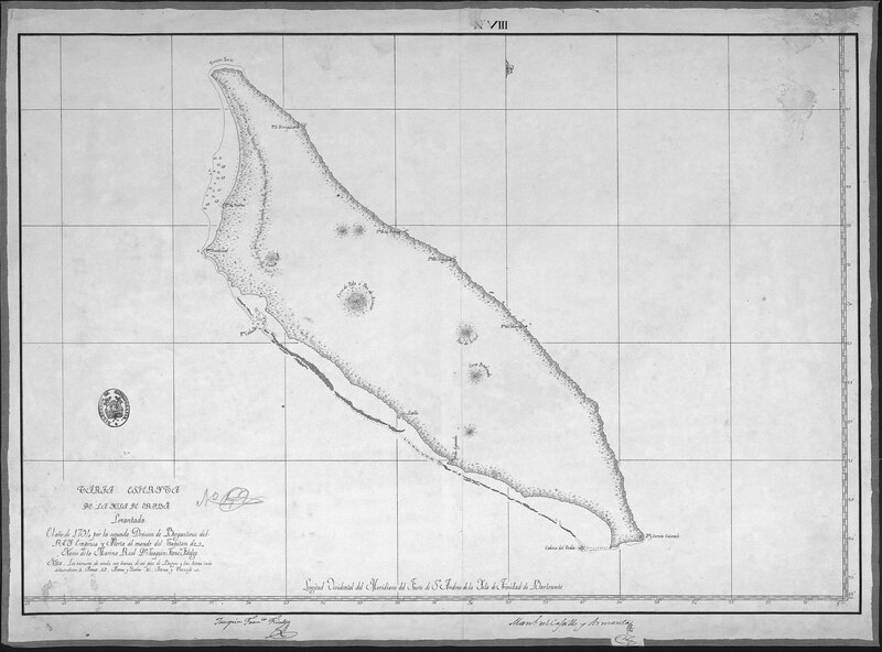
Spherical Chart of the Island of Oruba (1794). Note: The numbers are Brazas. 1 Braza = 1.829 nautical meter/ 6 ft. The letters indicate; A = sand, AP = sand and rocks, AC = sand and gravel.
Summary
[edit]| Description |
English: Hydrographic Expedition of the Atlas of North America (1793-1804). Commissioned in the year 1794 by the Second Division of Bergantines of the King Company and Alert under the command of the Captain of the Royal Navy Dn. Joaquin Franco Fidalgo; Manuel del Castillo Armenta |
| Date | |
| Source | Biblioteca Virtual de Defensa |
| Author | Expedición Hidrográfica del Atlas de la América Septentrional |
Licensing
[edit]| This file is made available under the Creative Commons CC0 1.0 Universal Public Domain Dedication. | |
| The person who associated a work with this deed has dedicated the work to the public domain by waiving all of their rights to the work worldwide under copyright law, including all related and neighboring rights, to the extent allowed by law. You can copy, modify, distribute and perform the work, even for commercial purposes, all without asking permission.
|
File history
Click on a date/time to view the file as it appeared at that time.
| Date/Time | Thumbnail | Dimensions | User | Comment | |
|---|---|---|---|---|---|
| current | 16:55, 23 March 2023 |  | 9,191 × 6,800 (1.84 MB) | Kallmemel (talk | contribs) | Uploaded a work by Expedición Hidrográfica del Atlas de la América Septentrional from https://bibliotecavirtual.defensa.gob.es/BVMDefensa/i18n/consulta/registro.cmd?id=38551 with UploadWizard |
You cannot overwrite this file.
File usage on Commons
There are no pages that use this file.