File:Caozhou Fu Shan Xian nan di dong hao tu. LOC 73693312.tif
Jump to navigation
Jump to search

Size of this JPG preview of this TIF file: 519 × 600 pixels. Other resolutions: 208 × 240 pixels | 415 × 480 pixels | 664 × 768 pixels | 886 × 1,024 pixels | 1,772 × 2,048 pixels | 7,864 × 9,088 pixels.
Original file (7,864 × 9,088 pixels, file size: 204.49 MB, MIME type: image/tiff)
Captions
Captions
Add a one-line explanation of what this file represents
Summary
[edit]| Description |
English: Scale not given. Shows dikes along north of Yellow River in Shan Xian, Caozhou Prefecture, Shandong Province. Manuscript, pen-and-ink and watercolor. Oriented with north to the bottom. Available also through the Library of Congress Web site as a raster image. Gift; W.W. Rockhill; 1904. Prev. Call no.: G7823.S33R4 1866 .C3 Vault AACR2 651 updated; cc14 2015-10-01. |
||
| Title | Caozhou Fu Shan Xian nan di dong hao tu. | ||
| Shelf ID | G7823.S33R4 1855 .C3 | ||
| Date | |||
| Source | https://www.loc.gov/item/73693312/ | ||
| Author | Rockhill, William Woodville | ||
| Permission (Reusing this file) |
|
||
| Other versions |
|
||
| Location | Shan Xian · Shandong · China · Sheng | ||
| Part of | American Memory · General Maps · Catalog · Geography And Map Division | ||
| Subject | Maps, Manuscript · Fortification · Shan Xian · Dikes · Maps · China · Shan Xian (Shandong, Sheng, China) |


Licensing
[edit]|
This is a faithful photographic reproduction of a two-dimensional, public domain work of art. The work of art itself is in the public domain for the following reason:
The official position taken by the Wikimedia Foundation is that "faithful reproductions of two-dimensional public domain works of art are public domain".
This photographic reproduction is therefore also considered to be in the public domain in the United States. In other jurisdictions, re-use of this content may be restricted; see Reuse of PD-Art photographs for details. | ||||
File history
Click on a date/time to view the file as it appeared at that time.
| Date/Time | Thumbnail | Dimensions | User | Comment | |
|---|---|---|---|---|---|
| current | 11:31, 9 August 2022 |  | 7,864 × 9,088 (204.49 MB) | Sebastian Wallroth (talk | contribs) | c:User:Rillke/bigChunkedUpload.js: |
| 13:38, 23 June 2018 | 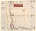 | 9,088 × 7,864 (204.47 MB) | Fæ (talk | contribs) | LOC Maps https://www.loc.gov/item/73693312/ #25513 |
You cannot overwrite this file.
File usage on Commons
The following 2 pages use this file: