File:Cambridge-Shire - By H. Moll Geographer - btv1b530568644.jpg
Original file (3,048 × 4,304 pixels, file size: 1.95 MB, MIME type: image/jpeg)
Captions
Captions
Summary
[edit]| English: Cambridgshire by H. Moll Geographer
( |
|||||||||||||||||||||||||||
|---|---|---|---|---|---|---|---|---|---|---|---|---|---|---|---|---|---|---|---|---|---|---|---|---|---|---|---|
| Author |
|
||||||||||||||||||||||||||
| Title |
English: Cambridgshire by H. Moll Geographer |
||||||||||||||||||||||||||
| Description |
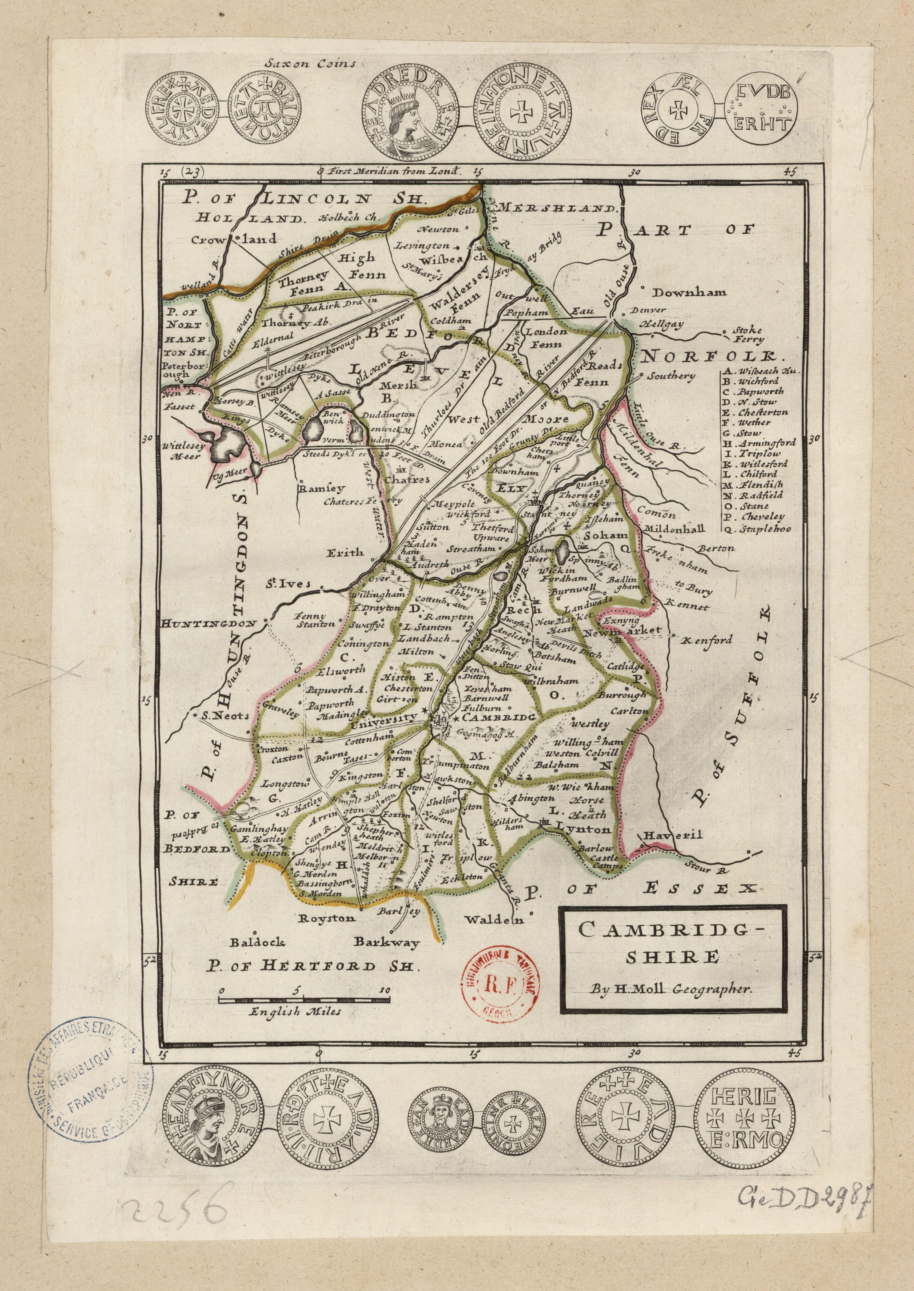
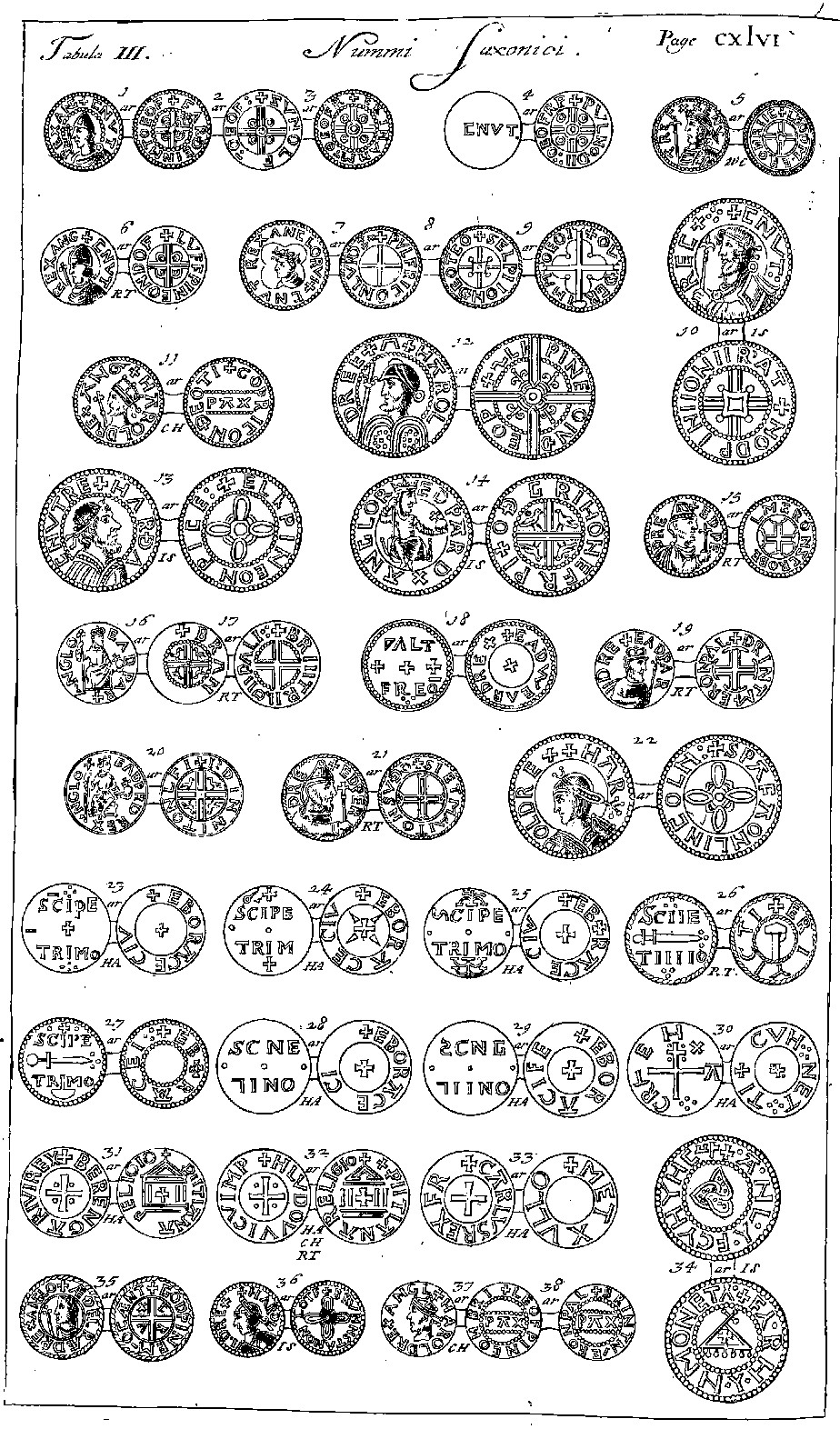
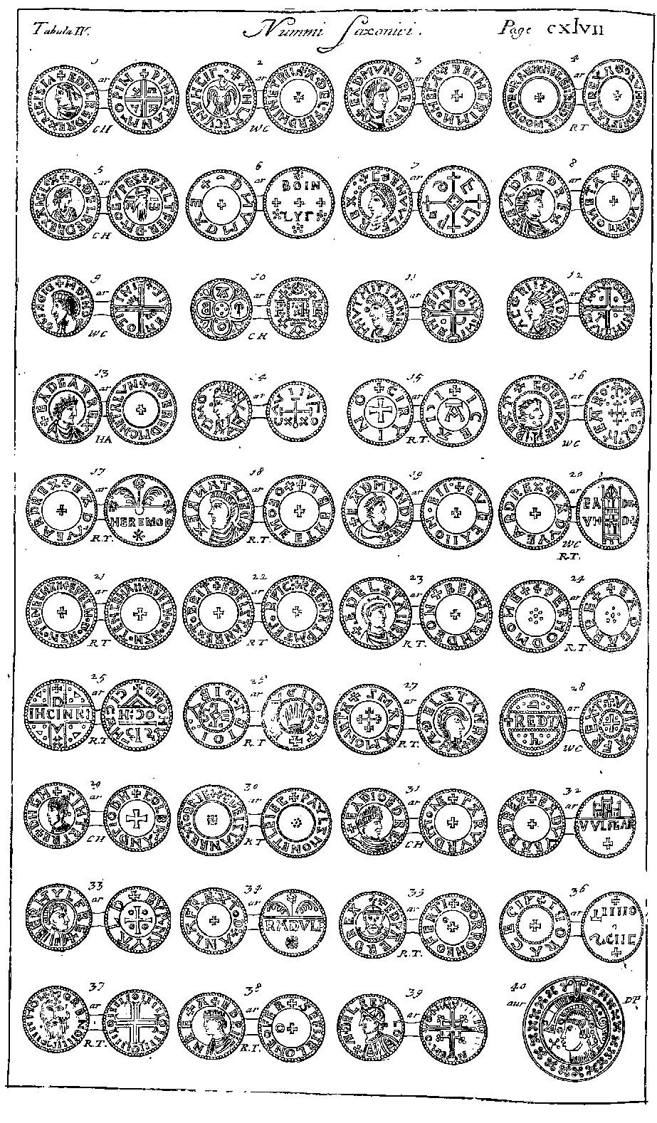
English: Moll's map of Cambridgeshire, sold separately and as Map 23 in his Set of Fifty New and Correct Maps of England and Wales... Illustrations in the margins of Saxon coins copied from Tabula II Nummi Saxonici on Page 139, Tabula III Nummi Saxonici on Page 146, and Tabula IV Nummi Saxonici on Page 147 of Obadiah Walker's "Notes on the Saxon Coins" appended to the English translation of William Camden's Britannica.
Français : Sujet : Monnaies
Divisions politiques et administratives Cambridge, Comté de -- Divisions politiques et administratives Échelle(s) : 10 English Miles [= 4,8 cm] Référence bibliographique : 173 Appartient à l’ensemble documentaire : AnvilEur Appartient à l’ensemble documentaire : MAEDI008 Appartient à l’ensemble documentaire : MAEDIGen0 Couverture : Royaume-Uni – Angleterre – Cambridgeshire Langue : anglais Éditeur : [T. Bowles] (London) |
||||||||||||||||||||||||||
| Date | 1724 | ||||||||||||||||||||||||||
| Dimensions | height: 23.5 cm (9.2 in); width: 34 cm (13.3 in) | ||||||||||||||||||||||||||
| Collection |
|
||||||||||||||||||||||||||
| References |
Français : Notice de recueil : http://catalogue.bnf.fr/ark:/12148/cb40577015h
Appartient à : Collection d'Anville ; 02256 Notice du catalogue : http://catalogue.bnf.fr/ark:/12148/cb41292636z Extrait de A New Description of England and Wales, With the Adjacent Islands, 1724. |
||||||||||||||||||||||||||
| Source/Photographer |
Français : Bibliothèque nationale de France, département Cartes et plans, GE DD-2987 (2256)
Bibliothèque nationale de France |
||||||||||||||||||||||||||
| Other versions |
|
||||||||||||||||||||||||||


|
This work is in the public domain in its country of origin and other countries and areas where the copyright term is the author's life plus 100 years or fewer. | |
| This file has been identified as being free of known restrictions under copyright law, including all related and neighboring rights. | |
| Annotations | This image is annotated: View the annotations at Commons |
File history
Click on a date/time to view the file as it appeared at that time.
| Date/Time | Thumbnail | Dimensions | User | Comment | |
|---|---|---|---|---|---|
| current | 00:31, 13 July 2022 | | 3,048 × 4,304 (1.95 MB) | Gzen92Bot (talk | contribs) | Gallica btv1b530568644 |
You cannot overwrite this file.
File usage on Commons
The following 22 pages use this file:
- File:Cambridge-Shire - By H. Moll Geographer - btv1b530568644.jpg
- File:Huntingdon-Shire - By H. Moll Geographer - btv1b530567997.jpg
- File:Norfolk - By H. Moll Geographer - btv1b53056714p.jpg
- File:Saxon Coin 15.jpg
- File:Saxon Coin 15a.jpg
- File:Saxon Coin 15b.jpg
- File:Saxon Coin 16.jpg
- File:Saxon Coin 16a.jpg
- File:Saxon Coin 16b.jpg
- File:Saxon Coin 17.jpg
- File:Saxon Coin 17a.jpg
- File:Saxon Coin 17b.jpg
- File:Saxon Coin 18.jpg
- File:Saxon Coin 18a.jpg
- File:Saxon Coin 18b.jpg
- File:Saxon Coin 19.jpg
- File:Saxon Coin 19a.jpg
- File:Saxon Coin 19b.jpg
- File:Saxon Coin 20.jpg
- File:Saxon Coin 20a.jpg
- File:Saxon Coin 20b.jpg
- File:Suffolk - By H. Moll Geographer - btv1b53056965z.jpg