File:California Atmospheric River Storms Captured by NASA's AIRS (PIA25597).tiff

Original file (1,195 × 611 pixels, file size: 1.78 MB, MIME type: image/tiff)
Captions
Captions
Summary
[edit]| Description |
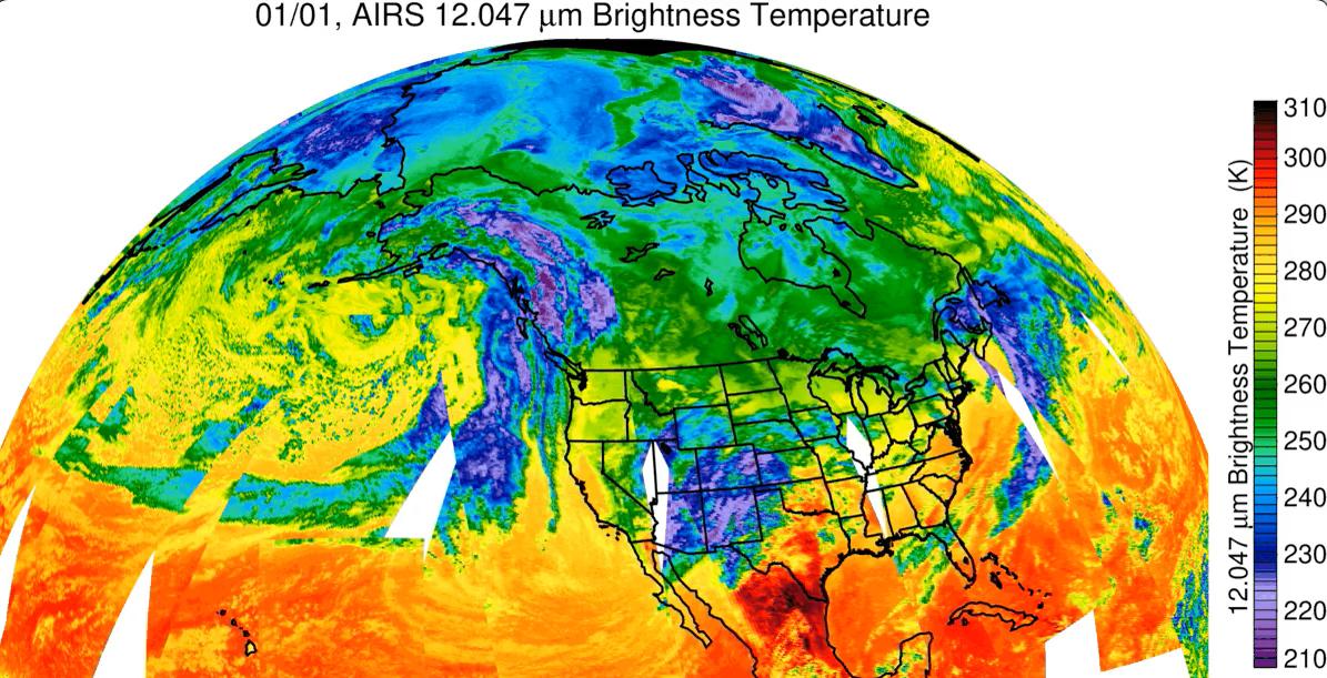
English: Since the start of 2023 California has been drenched by a series of storms being transported by an atmospheric river – a relatively narrow, windy region in Earth's atmosphere that can transport moisture or tiny particles for thousands of miles, much like a river on land moves water. NASA's Atmospheric Infrared Sounder (AIRS) captured the series of storms as they dumped record amounts of rain in some parts of California, caused flooding, and damaged infrastructure. Forecasts say this pattern of storms will continue through the week of Jan. 9. The images show cloud temperatures taken at infrared wavelengths not visible to the human eye. Purple and violet areas are colder, between about minus 82 degrees Fahrenheit and minus 46 degrees Fahrenheit (minus 63 degrees Celsius to minus 44 degrees Celsius), than blue and green regions which are roughly minus 28 degrees Fahrenheit to 26 degrees Fahrenheit (minus 33 degrees Celsius to minus 3 degrees Celsius). Warmer red sections are between roughly 62 degrees Fahrenheit and 80 degrees Fahrenheit (17 degrees Celsius to 27 degrees Celsius), representing mostly cloud-free air. The cooler parts of the clouds are associated with very heavy rainfall. White patches represent gaps in satellite coverage. Located aboard the Aqua satellite AIRS, in conjunction with the Advanced Microwave Sounding Unit (AMSU), senses emitted infrared and microwave radiation from Earth to provide a 3D look at the planet's weather and climate. Working in tandem, the two instruments make simultaneous observations down to Earth's surface. With more than 2,000 channels sensing different regions of the atmosphere, the system creates a global, 3D map of atmospheric temperature and humidity, cloud amounts and heights, greenhouse gas concentrations, and many other atmospheric phenomena. Launched into Earth orbit in 2002 aboard NASA's Aqua spacecraft, the AIRS and AMSU instruments are managed by NASA's Jet Propulsion Laboratory in Southern California, under contract to NASA. JPL is a division of Caltech. More information about AIRS can be found at https://airs.jpl.nasa.gov. |
| Date | (published) |
| Source | Catalog page · Full-res (JPEG · TIFF) · Full-res ([ MP4]) · Full-res ([ GIF]) |
| Author | NASA/JPL-Caltech |
| Other versions |
|
.jpg)
This image or video was catalogued by Jet Propulsion Laboratory of the United States National Aeronautics and Space Administration (NASA) under Photo ID: PIA25597. This tag does not indicate the copyright status of the attached work. A normal copyright tag is still required. See Commons:Licensing. Other languages:
|
| This media is a product of the Aqua mission Credit and attribution belongs to the mission team, if not already specified in the "author" row |
Licensing
[edit]
|
The copyright holder of this file, NASA/JPL-Caltech, allows anyone to use it for any purpose, provided that the copyright holder is properly attributed. Redistribution, derivative work, commercial use, and all other use is permitted. |
|
|
| According to JPL's image use policy additional restriction is that no endorsement of any product or service by Caltech, JPL or NASA is claimed or implied.
Caltech's disclaimer: Caltech makes no representations or warranties with respect to ownership of copyrights in the images, and does not represent others who may claim to be authors or owners of copyright of any of the images, and makes no warranties as to the quality of the images. Caltech shall not be responsible for any loss or expenses resulting from the use of the images, and you release and hold Caltech harmless from all liability arising from such use. Usage on the English Wikipedia: On the English Wikipedia you can use the {{JPL Image}} template to display the copyright notice. (See w:Wikipedia:Using JPL images for details) |
File history
Click on a date/time to view the file as it appeared at that time.
| Date/Time | Thumbnail | Dimensions | User | Comment | |
|---|---|---|---|---|---|
| current | 12:47, 5 May 2024 |  | 1,195 × 611 (1.78 MB) | OptimusPrimeBot (talk | contribs) | #Spacemedia - Upload of https://photojournal.jpl.nasa.gov/tiff/PIA25597.tif via Commons:Spacemedia |
You cannot overwrite this file.
File usage on Commons
The following 2 pages use this file: