File:CARTE DU PARAGUAY DU CHILI DU DETROIT DE MAGELLAN &c - Guillaume de L'Isle, 1703-1708 - BL Maps K.Top.124.4.a (BLL01018640954).jpg

Original file (8,586 × 6,543 pixels, file size: 9.99 MB, MIME type: image/jpeg)
Captions
Captions
| Title |
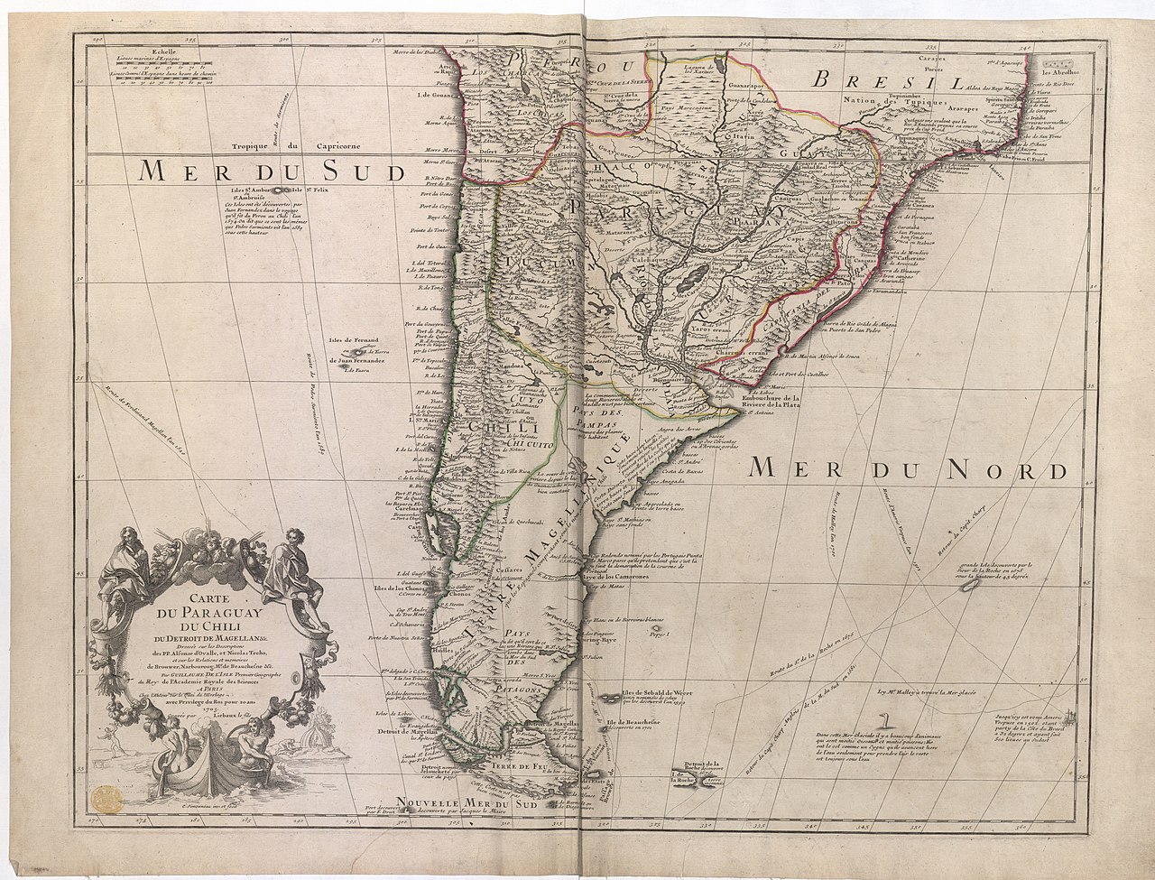
Français : CARTE DU PARAGUAY DU CHILI DU DETROIT DE MAGELLAN &c. : Dressée sur les Descriptions des PP. Alfonse d'Ovalle, et Nicolas Techo, et sur Relations et memoires de Brouwer, Narboroug, Mr. de Beauchesne &c. / Par GUILLAUME DE L'ISLE Premier Geographe du Roy de l'Academie Royale des Sciences. |
|||||||||||||||||||||||||||||||||||||
| Description |
English: State with Renard's imprint erased. Dated in line with R.V. Tooley. Appeared in G. de L'Isle's "Atlas de geographie", 1703-[1708]. |
|||||||||||||||||||||||||||||||||||||
| Date | [1703-1708] | |||||||||||||||||||||||||||||||||||||
| Source |
Part of King George III's Topographical Collection. Donated to the nation by George IV. Please do not overwrite this file. Any cropped or modified version should be uploaded with a new name and linked in the "
|
|||||||||||||||||||||||||||||||||||||
| Creator |
Cartographer:
|
|||||||||||||||||||||||||||||||||||||
| Contributor |
Engraver:
|
|||||||||||||||||||||||||||||||||||||
| Permission (Reusing this file) |
|
|||||||||||||||||||||||||||||||||||||
| Geotemporal data | ||||||||||||||||||||||||||||||||||||||
| Map location |
Chile |
|||||||||||||||||||||||||||||||||||||
| Scale | 1:9,000,000 | |||||||||||||||||||||||||||||||||||||
| OpenStreetMap zoom level | 3 | |||||||||||||||||||||||||||||||||||||
| Bounding box |
|
|||||||||||||||||||||||||||||||||||||
| Georeferencing | If inappropriate please set warp_status = skip to hide. | |||||||||||||||||||||||||||||||||||||
| Bibliographic data | ||||||||||||||||||||||||||||||||||||||
| Language | French | |||||||||||||||||||||||||||||||||||||
| Place of publication | Paris : Chez l'Auteur sur le Quai de l'Horloge. avec Privilege du Roi pour 20 ans 1703. | |||||||||||||||||||||||||||||||||||||
| Archival data | ||||||||||||||||||||||||||||||||||||||
| Collection | ||||||||||||||||||||||||||||||||||||||
| Accession number |
British Library Maps K.Top.124.4.a |
|||||||||||||||||||||||||||||||||||||
| Dimensions | height: 48 cm (18.8 in); width: 63 cm (24.8 in) | |||||||||||||||||||||||||||||||||||||
| Metadata note | Initial version of this page based on information from the BL catalogue entry, updated 2017-12-08. Used with permission. Accessed 2018-09-18. | |||||||||||||||||||||||||||||||||||||


File history
Click on a date/time to view the file as it appeared at that time.
| Date/Time | Thumbnail | Dimensions | User | Comment | |
|---|---|---|---|---|---|
| current | 19:28, 21 September 2018 | | 8,586 × 6,543 (9.99 MB) | JhealdBot (talk | contribs) | JhealdBot(6): test upload |
You cannot overwrite this file.
File usage on Commons
The following 2 pages use this file:
.jpg)
File usage on other wikis
The following other wikis use this file:
- Usage on www.wikidata.org
.jpg&oldid=842105000)
- 18th-century maps of the Strait of Magellan
- 1700s maps of Argentina
- 1700s maps of Chile
- 1700s maps of Paraguay
- 1700s maps of Uruguay
- Map of Paraguay, Chile and Argentina by Guillaume de l'Isle (1703)
- Henri Liébaux
- Charles Simonneau
- French-language maps of South America
- BL Maps K.Top.124 (South America)
- BL18C pilot