File:Byway on the County Boundary - geograph.org.uk - 1240785.jpg
Jump to navigation
Jump to search

Size of this preview: 450 × 600 pixels. Other resolutions: 180 × 240 pixels | 360 × 480 pixels | 576 × 768 pixels | 768 × 1,024 pixels | 1,944 × 2,592 pixels.
Original file (1,944 × 2,592 pixels, file size: 3.45 MB, MIME type: image/jpeg)
Captions
Captions
Add a one-line explanation of what this file represents
Summary
[edit]
| Description |
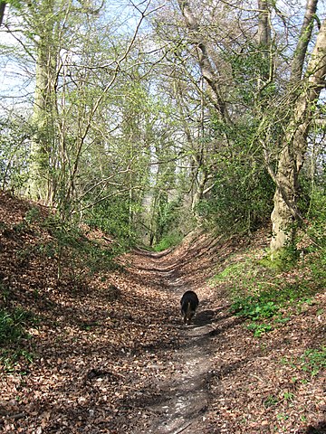
English: Byway on the County Boundary. A byway runs along the county boundary, with Pavis Wood on the west (Buckinghamshire) side and Hastoe House and the Dog Wood on the east (Hertfordshire) side. It is a continuation of Shire Lane, Hastoe, and is entered by the entrance to Pavis Wood 1240778. It is designated Tring No 36 on the Hertfordshire Footpath maps. It is almost certain that the route taken pre-dates the county boundary - and is hence more than a thousand years old - and perhaps very much older.
This is the first of a series of pictures following the byway down the slope. It shows the byway on the edge of the escarpment where it is just a shallow holloway. - developing into one of the deepest holloways I have ever seen - until the slope eases ant it becomes a normal track. The depth makes it obvious why, when roads were surfaced Shire Lane was not continued down the slope. |
| Date | Taken on 7 April 2009 |
| Source | From geograph.org.uk |
| Author | Chris Reynolds |
| Attribution (required by the license) | Chris Reynolds / Byway on the County Boundary / |
| Camera location | | View this and other nearby images on: OpenStreetMap |
|---|
_heading:0.00&language=en)
| Object location | | View this and other nearby images on: OpenStreetMap |
|---|
_heading:0.00&language=en)
Licensing
[edit]

|
This image was taken from the Geograph project collection. See this photograph's page on the Geograph website for the photographer's contact details. The copyright on this image is owned by Chris Reynolds and is licensed for reuse under the Creative Commons Attribution-ShareAlike 2.0 license.
|
This file is licensed under the Creative Commons Attribution-Share Alike 2.0 Generic license.
Attribution: Chris Reynolds
- You are free:
- to share – to copy, distribute and transmit the work
- to remix – to adapt the work
- Under the following conditions:
- attribution – You must give appropriate credit, provide a link to the license, and indicate if changes were made. You may do so in any reasonable manner, but not in any way that suggests the licensor endorses you or your use.
- share alike – If you remix, transform, or build upon the material, you must distribute your contributions under the same or compatible license as the original.
File history
Click on a date/time to view the file as it appeared at that time.
| Date/Time | Thumbnail | Dimensions | User | Comment | |
|---|---|---|---|---|---|
| current | 00:30, 7 September 2017 | | 1,944 × 2,592 (3.45 MB) | Geograph Update Bot (talk | contribs) | Higher-resolution version from Geograph. |
| 16:07, 26 February 2011 |  | 480 × 640 (283 KB) | GeographBot (talk | contribs) | == {{int:filedesc}} == {{Information |description={{en|1=Byway on the County Boundary A byway runs along the county boundary, with Pavis Wood on the west (Buckinghamshire) side and Hastoe House and the Dog Wood on the east (Hertfordshire) side. It is a co |
You cannot overwrite this file.
File usage on Commons
There are no pages that use this file.