File:Burro canyon formation.jpg
Jump to navigation
Jump to search

Size of this preview: 800 × 600 pixels. Other resolutions: 320 × 240 pixels | 640 × 480 pixels | 1,024 × 768 pixels | 1,280 × 960 pixels | 2,560 × 1,920 pixels | 4,608 × 3,456 pixels.
Original file (4,608 × 3,456 pixels, file size: 6.59 MB, MIME type: image/jpeg)
Captions
Captions
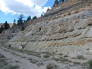
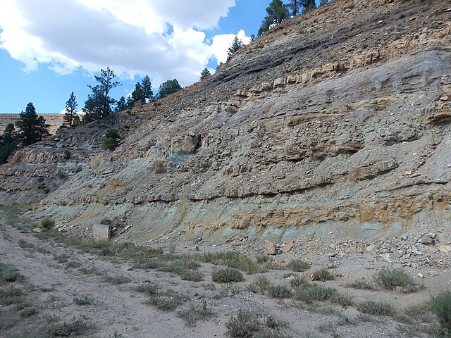
Outcrop of Burro Canylon Formations, Heron Lake spillway, New Mexico, United States
Summary
[edit]
| Description |
English: Sandstone, mudstone, and conglomerate beds of the Burro Canyon Formatin exposed in the spillway of Heron Lake. This is the earliest Cretaceous formation of the Chama Basin and underlies the Dakota Formation (whose base is the carboniferous layer near the top.) |
| Date | |
| Source | Own work |
| Author | Kent G. Budge |
| Camera location | | View this and other nearby images on: OpenStreetMap |
|---|
Licensing
[edit]
I, the copyright holder of this work, hereby publish it under the following license:
| This file is made available under the Creative Commons CC0 1.0 Universal Public Domain Dedication. | |
| The person who associated a work with this deed has dedicated the work to the public domain by waiving all of their rights to the work worldwide under copyright law, including all related and neighboring rights, to the extent allowed by law. You can copy, modify, distribute and perform the work, even for commercial purposes, all without asking permission.
|
File history
Click on a date/time to view the file as it appeared at that time.
| Date/Time | Thumbnail | Dimensions | User | Comment | |
|---|---|---|---|---|---|
| current | 16:52, 24 March 2020 | | 4,608 × 3,456 (6.59 MB) | Kent G. Budge (talk | contribs) | Uploaded own work with UploadWizard |
You cannot overwrite this file.
File usage on Commons
There are no pages that use this file.
File usage on other wikis
The following other wikis use this file:
- Usage on en.wikipedia.org