File:Bundestagswahlkreise 2017.svg
Jump to navigation
Jump to search

Size of this PNG preview of this SVG file: 504 × 599 pixels. Other resolutions: 202 × 240 pixels | 404 × 480 pixels | 646 × 768 pixels | 861 × 1,024 pixels | 1,723 × 2,048 pixels | 1,220 × 1,450 pixels.
Original file (SVG file, nominally 1,220 × 1,450 pixels, file size: 1.47 MB)
Captions
Captions
Add a one-line explanation of what this file represents
Summary
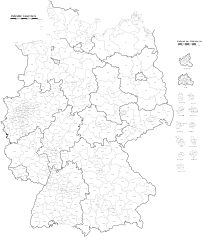
[edit]| Description |
Deutsch: Wahlkreiseinteilung zur Bundestagswahl 2017.
English: Constituencies for the German federal election, 2017. |
|||
| Date | ||||
| Source | Wahlkreiseinteilung, Bundestagswahl 2017 (with modifications) | |||
| Author | Furfur | |||
| Permission (Reusing this file) |
|
|||
| SVG development | This vector image was created with Adobe Illustrator. |


|
This SVG file contains embedded text that can be translated into your language, using any capable SVG editor, text editor or the SVG Translate tool. For more information see: About translating SVG files. |
File history
Click on a date/time to view the file as it appeared at that time.
| Date/Time | Thumbnail | Dimensions | User | Comment | |
|---|---|---|---|---|---|
| current | 12:22, 25 September 2017 | | 1,220 × 1,450 (1.47 MB) | Christallkeks (talk | contribs) | Fix Meer bei Borkum, fix einige Zuordnungen Wahlkreis <-> CSS-Klasse, add weitere CSS-Klassen für Beschriftungen |
| 21:50, 24 September 2017 |  | 1,220 × 1,450 (1.47 MB) | Christallkeks (talk | contribs) | Farbgebung geändert (Graustufen statt stechendem Rot) | |
| 21:42, 24 September 2017 |  | 1,220 × 1,450 (1.47 MB) | Christallkeks (talk | contribs) | Strukturierung des SVG-Codes weiter verbessert | |
| 20:19, 24 September 2017 |  | 1,220 × 1,450 (1.47 MB) | Christallkeks (talk | contribs) | Text-Tags aufgeräumt | |
| 19:15, 24 September 2017 |  | 1,220 × 1,450 (1.56 MB) | Christallkeks (talk | contribs) | Farbgebung der Wahlkreise über CSS-Klassen (statt hart-codiert im jeweiligen Polygon) | |
| 19:31, 17 September 2017 |  | 1,220 × 1,450 (1.57 MB) | Furfur (talk | contribs) | jetzt auch mit Flächen, zum Selberausmalen ... | |
| 15:12, 17 September 2017 |  | 1,598 × 1,908 (1.83 MB) | Furfur (talk | contribs) | == {{int:filedesc}} == {{Information |Description={{User:Medium69/Traduction}} {{de|1=Wahlkreiseinteilung zur Bundestagswahl 2017.}} {{en|1=Constituencies for the German federal election, 2017.}} |Source=[https://www.bundeswahlleiter.de/bundestagswahle... |
You cannot overwrite this file.
File usage on Commons
The following 2 pages use this file:
File usage on other wikis
The following other wikis use this file:
- Usage on de.wikipedia.org
- Usage on es.wikipedia.org