File:British Coin 2.jpg
Original file (286 × 636 pixels, file size: 43 KB, MIME type: image/jpeg)
Captions
Captions
Summary
[edit]| English: British Coins
( |
|||||||||||||||||||||||||||
|---|---|---|---|---|---|---|---|---|---|---|---|---|---|---|---|---|---|---|---|---|---|---|---|---|---|---|---|
| Author |
|
||||||||||||||||||||||||||
| Title |
English: British Coins |
||||||||||||||||||||||||||
| Description |
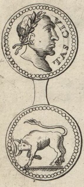
English: A depiction of the obverse and reverse of a silver coin of Tasciovanus from the figures decorating the margins of Moll's map of Gloucestershire, sold separately and as Map 14 in his Set of Fifty New and Correct Maps of England and Wales... The illustration derives from figure 17 of Tabula I Nummi Britannici on Page 87 of William Camden's Britannia, Vol. I. Camden's English text for the coin reads "The 17th the image of Augustus, and TASCIA; on the reverse a bull pushing." Elsewhere, he relates that the inscription TASCIA "in British signifies a tribute-penny (as I am informed by D. David Powel, a man admirably skilled in that language;) perhaps from the Latin taxatio, for the Britons do not use the letter x. And upon the same account, we see moneta often upon the Roman coins." In fact, although this misunderstanding became widespread, the inscription is actually a form of the name Tasciovanus, later continued on the coinage of his son Cunobelinus (1).
Français : Sujet : Monnaies
Divisions politiques et administratives Gloucester, Comté de -- Divisions politiques et administratives Échelle(s) : 10 English Miles [= 3,8 cm] Référence bibliographique : 173 Appartient à l’ensemble documentaire : AnvilEur Appartient à l’ensemble documentaire : MAEDI008 Appartient à l’ensemble documentaire : MAEDIGen0 Couverture : Royaume-Uni – Angleterre – Gloucestershire Langue : anglais Éditeur : [T. Bowles] (London) |
||||||||||||||||||||||||||
| Date |
Original coin: 20 BC–AD 9 |
||||||||||||||||||||||||||
| Dimensions | height: 33 cm (12.9 in); width: 21 cm (8.2 in) | ||||||||||||||||||||||||||
| Collection |
|
||||||||||||||||||||||||||
| References |
Français : Notice de recueil : http://catalogue.bnf.fr/ark:/12148/cb40577015h
Appartient à : Collection d'Anville ; 02187 Notice du catalogue : http://catalogue.bnf.fr/ark:/12148/cb41247598d Extrait de A New Description of England and Wales, With the Adjacent Islands, 1724. |
||||||||||||||||||||||||||
| Source/Photographer |
Français : Bibliothèque nationale de France, département Cartes et plans, GE DD-2987 (2187)
Bibliothèque nationale de France |
||||||||||||||||||||||||||
| Permission (Reusing this file) |
|
||||||||||||||||||||||||||
| Other versions |
|
||||||||||||||||||||||||||


.jpg)

| Annotations | This image is annotated: View the annotations at Commons |
File history
Click on a date/time to view the file as it appeared at that time.
| Date/Time | Thumbnail | Dimensions | User | Comment | |
|---|---|---|---|---|---|
| current | 08:50, 9 November 2023 | | 286 × 636 (43 KB) | LlywelynII (talk | contribs) | File:Glocester Shire - By H. Moll Geographer - btv1b53056595p.jpg cropped using CropTool. |
You cannot overwrite this file.
File usage on Commons
The following 4 pages use this file:
- Coins of Tasciovanus
- 1724 engravings
- A Set of Fifty New and Correct Maps of England and Wales
- Bulls on coins
- Laurel wreaths in art
- Britannia: or, a Chorographical Description of the Flourishing Kingdoms of England, Scotland, and Ireland, and the Islands
- Both sides of coins
- Latin inscriptions on coins
- Kings on coins
- Silver coins
- Men facing right on coins