File:Brion de La Tour. Carte de l'empire Ottoman par la paix entre les russes et les turcs, par un traité entre la M. d'Autriche et le G. seigneur. 1775.jpg
Jump to navigation
Jump to search

Size of this preview: 678 × 599 pixels. Other resolutions: 272 × 240 pixels | 543 × 480 pixels | 869 × 768 pixels | 1,159 × 1,024 pixels | 2,318 × 2,048 pixels | 3,542 × 3,130 pixels.
Original file (3,542 × 3,130 pixels, file size: 3.38 MB, MIME type: image/jpeg)
Captions
Captions
Add a one-line explanation of what this file represents
Summary
[edit]| Artist |
Brion de La Tour, Louis (1756-1803 ; ingénieur-géographe). Cartographe. Publisher: Brion (A Paris) |
||||||||||||||||||||||||||
| Title |
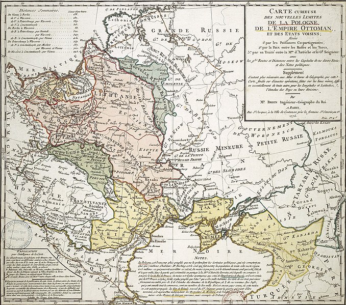
Français : Carte curieuse des nouvelles limites de la Pologne, de l'empire Ottoman et des états voisins fixées par les puissances copartageantes, par la paix entre les russes et les turcs, par un traité entre la M. d'Autriche et le G. seigneur |
||||||||||||||||||||||||||
| Description |
Français : Carte curieuse des nouvelles limites de la Pologne, de l'empire Ottoman et des états voisins fixées par les puissances copartageantes, par la paix entre les russes et les turcs, par un traité entre la M. d'Autriche et le G. seigneur / par Mr. Brion |
||||||||||||||||||||||||||
| Date | 1775 | ||||||||||||||||||||||||||
| Dimensions |
Français : en coul. 36 × 40.5 cm (14.1 × 15.9 in). sur flle 41.5 × 49.5 cm (16.3 × 19.4 in) |
||||||||||||||||||||||||||
| Collection |
|
||||||||||||||||||||||||||
| Current location |
Paris |
||||||||||||||||||||||||||
| Accession number |
IFN- 5905189 |
||||||||||||||||||||||||||
| Object history | Collection d'Anville | ||||||||||||||||||||||||||
| Source/Photographer |
Bibliothèque nationale de France |
||||||||||||||||||||||||||

Licensing
[edit]
| Previous public domain rationale, no longer applicable | ||
|---|---|---|
|
|
This is a faithful photographic reproduction of a two-dimensional, public domain work of art. The work of art itself is in the public domain for the following reason:
The official position taken by the Wikimedia Foundation is that "faithful reproductions of two-dimensional public domain works of art are public domain".
This photographic reproduction is therefore also considered to be in the public domain in the United States. In other jurisdictions, re-use of this content may be restricted; see Reuse of PD-Art photographs for details. | ||||
File history
Click on a date/time to view the file as it appeared at that time.
| Date/Time | Thumbnail | Dimensions | User | Comment | |
|---|---|---|---|---|---|
| current | 22:59, 24 May 2011 | | 3,542 × 3,130 (3.38 MB) | Geagea (talk | contribs) | without borders |
| 22:44, 24 May 2011 |  | 4,520 × 5,849 (5.45 MB) | Geagea (talk | contribs) | == {{int:filedesc}} == {{LargeImage}} {{Artwork |artist=Brion de La Tour, Louis (1756-1803 ; ingénieur-géographe). Cartographe. <br />'''Publisher''': Brion (A Paris) |title={{fr|1=Carte curieuse des nouvelles limites de l |
You cannot overwrite this file.
File usage on Commons
The following 3 pages use this file:
- File:Brion de La Tour. Carte de l'empire Ottoman par la paix entre les russes et les turcs, par un traité entre la M. d'Autriche et le G. seigneur. 1775.A.jpg
- File:Brion de La Tour. Carte de l'empire Ottoman par la paix entre les russes et les turcs, par un traité entre la M. d'Autriche et le G. seigneur. 1775.B.jpg
- File:Brion de La Tour. Carte de l'empire Ottoman par la paix entre les russes et les turcs, par un traité entre la M. d'Autriche et le G. seigneur. 1775.jpg