File:Bradgate park geology map.png
Jump to navigation
Jump to search
No higher resolution available.
Bradgate_park_geology_map.png (529 × 397 pixels, file size: 264 KB, MIME type: image/png)
Captions
Captions
Add a one-line explanation of what this file represents
Summary
[edit]
| Description |
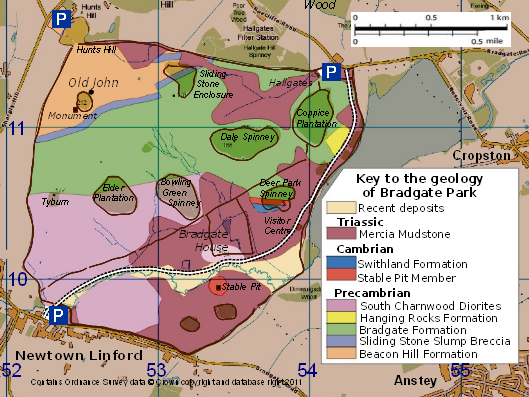
English: Map of Bradgate Park, Leicestershire, England, showing the surface geology within the park, including Precambrian, Cambrian and Triassic rocks. |
| Date | |
| Source | created by Robin Stevenson based on Ordnance Survey data © Crown copyright and database right 2011 available under OS Opendata, from OS Vectormap District raster map SK51, downloadable from https://www.ordnancesurvey.co.uk/opendatadownload/products.html with geological information drawn from Carney, J. N. (2010). Guide to the Geology of Bradgate Park and Swithland Wood, Charnwood Forest. Occasional Report, OR/10/041. British Geological Survey. http://nora.nerc.ac.uk/11705 |
| Author | Robin Stevenson based on Ordnance Survey data © Crown copyright and database right 2011 under UK Open Government licence at http://www.nationalarchives.gov.uk/doc/open-government-licence/open-government-licence.htm |
Licensing
[edit]
This file is licensed by the Ordnance Survey of the United Kingdom under their OS OpenData License
In short: you are free to distribute and modify the file as long as you attribute (including year), the Ordnance Survey. Attribution: Contains Ordnance Survey data © Crown copyright and database right (year) Note: Derivative works can be licensed under any Creative Commons Attribution 3.0 Licence. |
_(St_Edwards_Crown).svg)
|
This file is licensed under the United Kingdom Open Government Licence v3.0. |
See also: Meta for information on usage on Wikimedia wikis.
|
File history
Click on a date/time to view the file as it appeared at that time.
| Date/Time | Thumbnail | Dimensions | User | Comment | |
|---|---|---|---|---|---|
| current | 18:21, 27 January 2011 | | 529 × 397 (264 KB) | RobinLeicester (talk | contribs) | {{Information |Description ={{en|1=Map of Bradgate Park, Leicestershire, England, showing the surface geology within the park, including Precambrian, Cambrian and Triassic rocks.}} |Source =created by Robin Stevenson based on Ordnance Survey da |
You cannot overwrite this file.
File usage on Commons
There are no pages that use this file.
File usage on other wikis
The following other wikis use this file:
- Usage on de.wikipedia.org
- Usage on en.wikipedia.org
- Usage on zh.wikipedia.org
Categories:
- Maps of Leicestershire
- Hills of Leicestershire
- Geological maps of England
- Precambrian geology of England
- Cambrian geology of England
- Triassic geology of England
- Bradgate Park
- Surface geology maps of the United Kingdom
- Swithland Slate
- Stable Pit Member
- Mercia Mudstone Group
- Precambrian diorite
- Diorite formations in the United Kingdom
- Beacon Hill Formation
- Geology of Leicestershire
- South Charnwood Diorite