File:Bosnia around 1412-sh.png
Jump to navigation
Jump to search

Size of this preview: 642 × 600 pixels. Other resolutions: 257 × 240 pixels | 514 × 480 pixels | 884 × 826 pixels.
Original file (884 × 826 pixels, file size: 113 KB, MIME type: image/png)
Captions
Captions
Add a one-line explanation of what this file represents
Summary
[edit]
| Description |
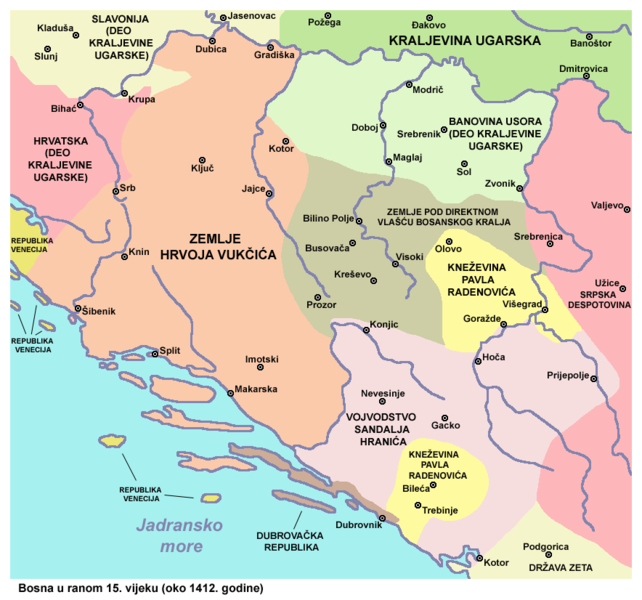
English: Bosnia in the early 15th century (around 1412) - Lands of Hrvoje Vukčić, Duchy of Sandalj Hranić, Principality of Pavle Radenović, Banovina Usora and Lands under the direct authority of the Bosnian king. Srpskohrvatski / српскохрватски: Bosna u ranom 15. veku (oko 1412. godine) - Oblast Hrvoja Vukčića, Vojvodstvo Sandalja Hranića, Kneževina Pavla Radenovića, Banovina Usora i zemlje pod direktnom vlašću bosanskog kralja. |
| Date | |
| Source | Own work |
| Author | PANONIAN |
Licensing
[edit]
I, the copyright holder of this work, hereby publish it under the following license:
| This file is made available under the Creative Commons CC0 1.0 Universal Public Domain Dedication. | |
| The person who associated a work with this deed has dedicated the work to the public domain by waiving all of their rights to the work worldwide under copyright law, including all related and neighboring rights, to the extent allowed by law. You can copy, modify, distribute and perform the work, even for commercial purposes, all without asking permission.
|
References
[edit]
- Istorijski atlas, Geokarta, Beograd, 1999.
- Vladimir Ćorović, Ilustrovana istorija Srba, knjiga treća, Beograd, 2006.
- Školski istorijski atlas, Zavod za izdavanje udžbenika SR Srbije, Beograd, 1970.
- http://www.rodnikraj.eu/index_htm_files/247.png[dead link]
- http://www.hercegbosna.org/STARO/images/zem20.jpg
File history
Click on a date/time to view the file as it appeared at that time.
| Date/Time | Thumbnail | Dimensions | User | Comment | |
|---|---|---|---|---|---|
| current | 14:34, 25 April 2014 | | 884 × 826 (113 KB) | PANONIAN (talk | contribs) | {{Information |Description ={{en|1=Bosnia in the early 15th century (around 1412) - Realm of Hrvoje Vukčić, Duchy of Sandalj Hranić, Principality of Pavle Radenović, Banovina Usora and Lands under the direct authority of the Bosnian king.}} |Sou... |
You cannot overwrite this file.
File usage on Commons
There are no pages that use this file.
File usage on other wikis
The following other wikis use this file:
- Usage on bs.wikipedia.org
- Usage on hr.wikipedia.org
- Usage on sh.wikipedia.org
Categories:
- Maps of the Kingdom of Bosnia
- Maps of counties of medieval Bosnian state
- Maps of the Serbian Despotate
- Mape posjeda Velikog vojvodstva Kosača u XV v.
- Maps of the history of Croatia in the Middle Ages
- Maps of the history of Slavonia
- Maps of the history of Dalmatia
- Maps of the Republic of Ragusa
- Maps in Serbian (Latin)
- Serbo-Croatian-language maps
- Usora (region)