File:BlackRockGunneryRangeElkoAeroChart1955.png
Jump to navigation
Jump to search

Size of this preview: 287 × 599 pixels. Other resolutions: 115 × 240 pixels | 230 × 480 pixels | 368 × 768 pixels | 491 × 1,024 pixels | 1,829 × 3,816 pixels.
Original file (1,829 × 3,816 pixels, file size: 16.77 MB, MIME type: image/png)
Captions
Captions
Add a one-line explanation of what this file represents
Summary
[edit]
| Description |
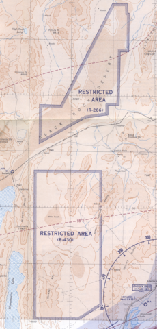
English: This 1955 Elko Sectional Aeronautical Chart shows the approximate location of the Black Rock Desert Gunnery Range. The back side of the map has a table titled "U. S. Prohibited, Restricted, Caution and Warning Areas on Elko Sectional Chart". The table states that R-266 is the "Black Rock Desert," which is has the following activities: "Air-to-Air Gunnery, Rocket and Bombing and Photo Flash Bombs."
The table states that R-430 is the "Sahwave Mountains," which has the following activities: "Air-to-Air Gunnery." Both areas are used by the COMNABS 12th Naval District and have unlimited altitude and time. The "R" signifies that the areas are Restricted. The table states: "Unauthorized flight is not permitted within a Prohibited Area, or within a Restricted Area during the time of use and between the altitudes notes in the tabulation. (Authorization may be granted by the controlling agency or by Executive Order of the President)." |
| Date | |
| Source | Elko Sectional Aeronautical Chart (32nd Edition) Revised Sept. 1955 |
| Author | U. S. Coast Guard and Geodetic Survey |
| Camera location | | View this and other nearby images on: OpenStreetMap |
|---|
Licensing
[edit]
This image or file is a work of a United States Coast Guard service personnel or employee, taken or made as part of that person's official duties. As a work of the U.S. federal government, the image or file is in the public domain (17 U.S.C. § 101 and § 105, USCG main privacy policy and specific privacy policy for its imagery server).
|
 |
File history
Click on a date/time to view the file as it appeared at that time.
| Date/Time | Thumbnail | Dimensions | User | Comment | |
|---|---|---|---|---|---|
| current | 23:33, 22 June 2013 | | 1,829 × 3,816 (16.77 MB) | Cxbrx (talk | contribs) | User created page with UploadWizard |
You cannot overwrite this file.
File usage on Commons
There are no pages that use this file.
File usage on other wikis
The following other wikis use this file:
- Usage on en.wikipedia.org
- Usage on www.wikidata.org