File:Bellin - Plan de la Ville de Moka.png
Jump to navigation
Jump to search

Size of this preview: 461 × 600 pixels. Other resolutions: 184 × 240 pixels | 369 × 480 pixels | 590 × 768 pixels | 787 × 1,024 pixels | 1,400 × 1,822 pixels.
Original file (1,400 × 1,822 pixels, file size: 4.7 MB, MIME type: image/png)
Captions
Captions
Add a one-line explanation of what this file represents
Summary
[edit]
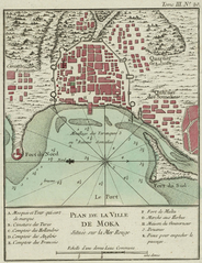
Jacques-Nicolas Bellin: Plan de la Ville de Moka, from: Le petit atlas maritime..., Vol. III, pl. 20, Paris 1764
| Jacques-Nicolas Bellin
(1703–1772) |
|||
|---|---|---|---|
| Alternative names |
Jacques Nicolas, Sieur Bellin; Jacques Nicolas Bellin; Nicolas Bellin | ||
| Description | French cartographer, encyclopédistes, geographer and hydrographer | ||
| Date of birth/death |
1703 |
21 March 1772 | |
| Location of birth/death | Paris | Versailles | |
| Authority file | |||
Licensing
[edit]
|
This work is in the public domain in its country of origin and other countries and areas where the copyright term is the author's life plus 100 years or fewer. | |
| This file has been identified as being free of known restrictions under copyright law, including all related and neighboring rights. | |
File history
Click on a date/time to view the file as it appeared at that time.
| Date/Time | Thumbnail | Dimensions | User | Comment | |
|---|---|---|---|---|---|
| current | 14:02, 22 February 2006 | | 1,400 × 1,822 (4.7 MB) | Frank Schulenburg (talk | contribs) | == Summary == Jacques-Nicolas Bellin: ''Plan de la Ville de Moka'', from: ''Le petit atlas maritime...'', Vol. III, pl. 20, Paris 1764 {{Creator:Jacques-Nicolas Bellin}} Category:18th century maps |
You cannot overwrite this file.
File usage on Commons
The following page uses this file:
File usage on other wikis
The following other wikis use this file:
- Usage on ar.wikipedia.org
- Usage on de.wikipedia.org
- Usage on en.wikipedia.org
- Usage on eo.wikipedia.org
- Usage on fr.wikipedia.org
- Usage on fy.wikipedia.org
- Usage on hy.wikipedia.org
- Usage on nl.wikipedia.org
- Usage on no.wikipedia.org
- Usage on pt.wikipedia.org
- Usage on ru.wikipedia.org
- Usage on sh.wikipedia.org
- Usage on zh.wikipedia.org