File:Battlefields in vicinity of Washington, D.C., reached via Southern Railway. LOC 99439194.tif
Jump to navigation
Jump to search

Size of this JPG preview of this TIF file: 800 × 558 pixels. Other resolutions: 320 × 223 pixels | 640 × 446 pixels | 1,024 × 714 pixels | 1,280 × 892 pixels | 2,560 × 1,785 pixels | 7,703 × 5,370 pixels.
Original file (7,703 × 5,370 pixels, file size: 118.35 MB, MIME type: image/tiff)
Captions
Captions
Add a one-line explanation of what this file represents
Summary
[edit]| Description |
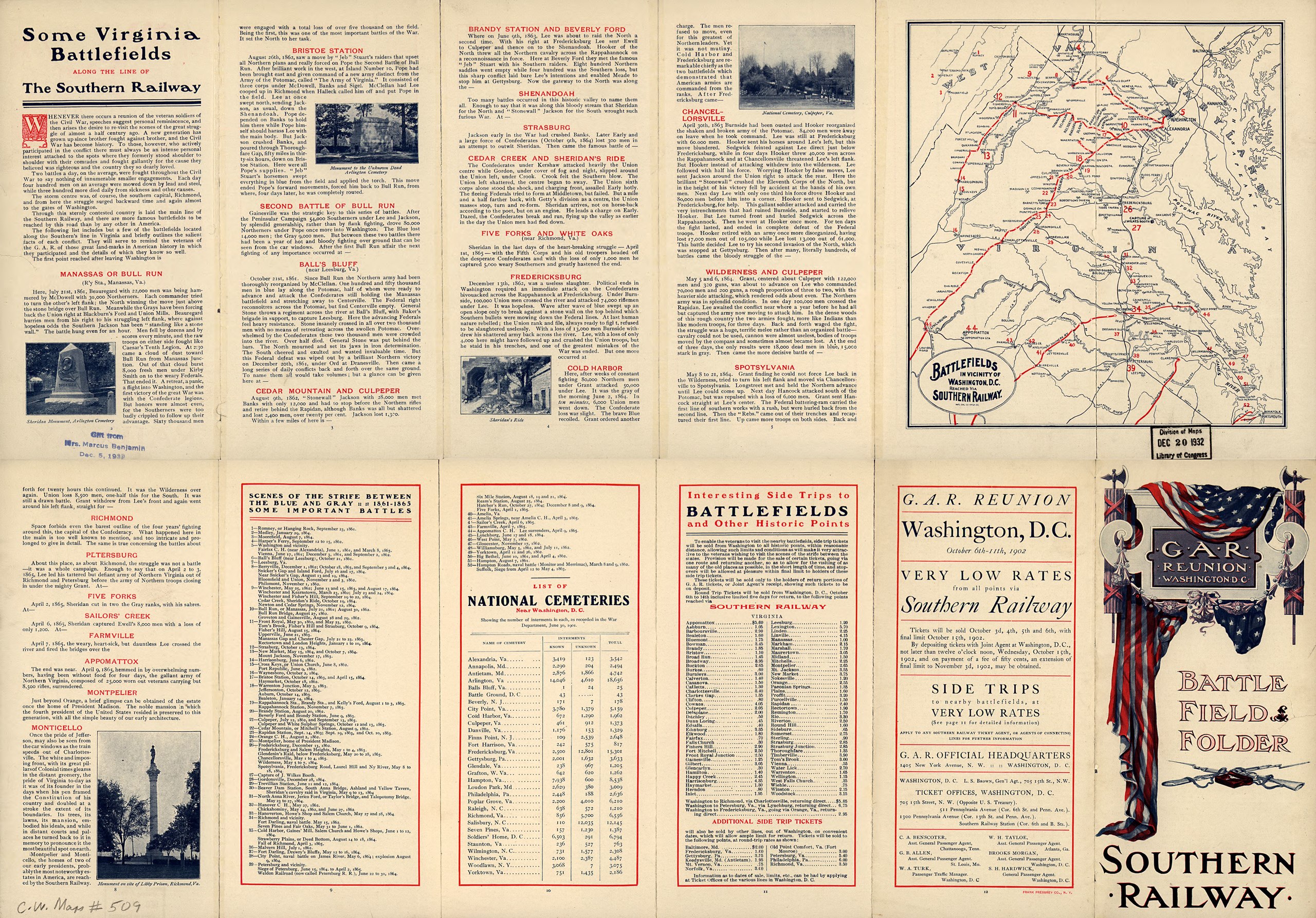
English: Scale not given. LC Civil War Maps (2nd ed.), 509 Title when folded: G.A.R. Reunion, Washington, D.C. Battle field folder. Southern Railway. Map of eastern Virginia showing the Southern Railway line in red, other railroads in blue, towns, and river. Battlefields are located by crossed swords. Folder contains brief descriptions of "some Virginia battlefields along the line of the Southern Railway," "list of National Cemeteries near Washington, D.C." cost of railroad tickets "to battlefields and other historic points," and a list of 52 "scenes of the strife between the Blue and Gray" each of which is keyed by number to the map. Description derived from published bibliography. Available also through the Library of Congress web site as raster image. |
||
| Title | Battlefields in vicinity of Washington, D.C., reached via Southern Railway. | ||
| Shelf ID | G3880 1902 .N3 | ||
| Date | |||
| Source | https://www.loc.gov/item/99439194/ | ||
| Author | Natl. Eng. Co. | ||
| Permission (Reusing this file) |
|
||
| Other versions |
|
||
| Location | United States · Virginia | ||
| Part of | Military Battles And Campaigns · American Memory · Civil War Maps · Catalog · Geography And Map Division | ||
| Subject | Battlefields · Virginia · Civil War · United States · Maps · History |


Licensing
[edit]|
This is a faithful photographic reproduction of a two-dimensional, public domain work of art. The work of art itself is in the public domain for the following reason:
The official position taken by the Wikimedia Foundation is that "faithful reproductions of two-dimensional public domain works of art are public domain".
This photographic reproduction is therefore also considered to be in the public domain in the United States. In other jurisdictions, re-use of this content may be restricted; see Reuse of PD-Art photographs for details. | ||||
File history
Click on a date/time to view the file as it appeared at that time.
| Date/Time | Thumbnail | Dimensions | User | Comment | |
|---|---|---|---|---|---|
| current | 09:02, 18 May 2018 |  | 7,703 × 5,370 (118.35 MB) | Fæ (talk | contribs) | LOC Maps https://www.loc.gov/item/99439194/ #10668 |
You cannot overwrite this file.
File usage on Commons
The following page uses this file: