File:BalticStatesBorders-de.svg
Jump to navigation
Jump to search

Size of this PNG preview of this SVG file: 747 × 593 pixels. Other resolutions: 302 × 240 pixels | 605 × 480 pixels | 968 × 768 pixels | 1,280 × 1,016 pixels | 2,560 × 2,032 pixels.
Original file (SVG file, nominally 747 × 593 pixels, file size: 230 KB)
Captions
Captions
Add a one-line explanation of what this file represents
Summary
[edit]| Description |
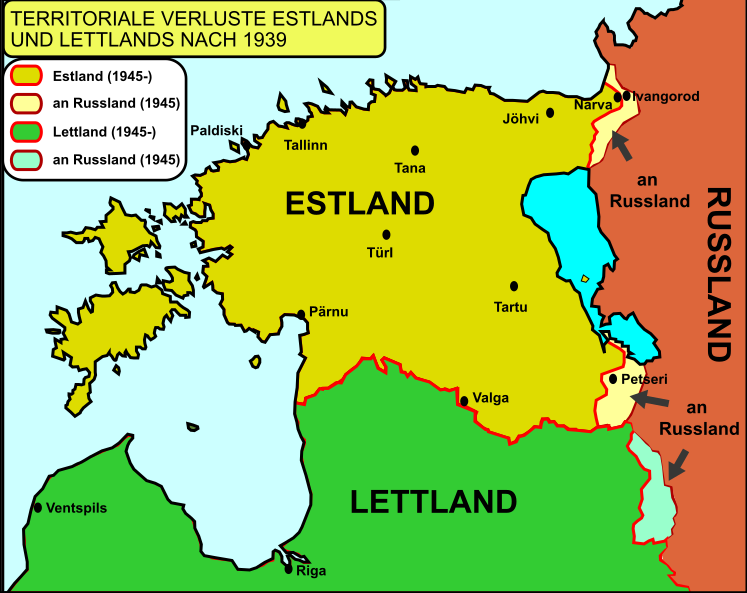
Deutsch: Territoriale Verluste Estlands und Lettlands an Russland in Folge des Hitler-Stalin-Paktes und der darauf folgenden Okkupation durch die Sowjetunion.
English: border changes of Estonia and Latvia between 1939 and 2001 Border changes drawn based on Goode's World Atlas, editions 1934 & 2001, RAND&McNALLY, CHICAGO Español: Cambios territoriales en Estonia y Letonia desde el comienzo de la Segunda Guerra Mundial. |
| Date | (UTC) |
| Source | |
| Author |
|
| Other versions |
|


| This is a retouched picture, which means that it has been digitally altered from its original version. Modifications: andere Farbgebung, kleinere Änderungen, deutsche Übersetzung. The original can be viewed here: BalticStatesBorders.svg:
|
Licensing
[edit]
I, the copyright holder of this work, hereby publish it under the following licenses:
| This file is licensed under the Creative Commons Attribution-Share Alike 3.0 Unported license. | ||
| ||
| This licensing tag was added to this file as part of the GFDL licensing update. |

|
Permission is granted to copy, distribute and/or modify this document under the terms of the GNU Free Documentation License, Version 1.2 or any later version published by the Free Software Foundation; with no Invariant Sections, no Front-Cover Texts, and no Back-Cover Texts. A copy of the license is included in the section entitled GNU Free Documentation License. |
You may select the license of your choice.
Original upload log
[edit]
This image is a derivative work of the following images:
- File:BalticStatesBorders.svg licensed with Cc-by-sa-3.0-migrated, GFDL
- 2010-01-08T22:47:31Z Rowanwindwhistler 721x593 (94835 Bytes) {{Information |Description={{en|1=border changes of Estonia and Latvia between 1939 and 2001 Border changes drawn based on Goode's World Atlas, editions 1934 & 2001, RAND&McNALLY, CHICAGO}} {{es|1=Cambios territoriales en Es
Uploaded with derivativeFX
File history
Click on a date/time to view the file as it appeared at that time.
| Date/Time | Thumbnail | Dimensions | User | Comment | |
|---|---|---|---|---|---|
| current | 23:30, 25 December 2011 | | 747 × 593 (230 KB) | Furfur (talk | contribs) | Bildkosmetik |
| 23:28, 25 December 2011 |  | 744 × 593 (230 KB) | Furfur (talk | contribs) | == {{int:filedesc}} == {{Information |Description={{de|1=Territoriale Verluste Estlands und Lettlands an Russland in Folge des Hitler-Stalin-Paktes und der darauf folgenden Okkupation durch die Sowjetunion.}} {{en|1=border changes of Estonia and Latvia be |
You cannot overwrite this file.
File usage on Commons
The following 2 pages use this file:
File usage on other wikis
The following other wikis use this file:
- Usage on de.wikipedia.org
- Usage on fr.wikipedia.org
- Usage on uk.wikipedia.org