File:Bahnstrecke-Niederwürschnitz-Stollberg-Planungsstand-2016.png
Jump to navigation
Jump to search

Size of this preview: 723 × 599 pixels. Other resolutions: 290 × 240 pixels | 579 × 480 pixels | 927 × 768 pixels | 1,236 × 1,024 pixels | 2,185 × 1,811 pixels.
Original file (2,185 × 1,811 pixels, file size: 2.92 MB, MIME type: image/png)
Captions
Captions
Add a one-line explanation of what this file represents
Summary
[edit]
| Description |
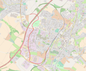
Deutsch: Verlauf der der geplanten Bahnstrecke Niederwürschnitz–Stollberg (rot) im Erzgebirgskreis, Sachsen, nach Planungsstand 11/2016
English: Proposed Niederwürschnitz–Stollberg railway line in Saxony, Germany (red) as planned in 2016 |
| Date | |
| Source |
Own work; Deutsch: Grundkarte aus OpenStreetMap (Stand 18. März 2017); Daten zum Streckenverlauf nach http://www.chemnitzer-modell.de/uploads/media/Chemnitzer_Modell_Aktuell_Ausgabe_4_November_2016.pdf (Stand: 3. November 2016)
English: Basic map from OpenStreetMap (as of 18 March 2017); data about proposed railway line according to http://www.chemnitzer-modell.de/uploads/media/Chemnitzer_Modell_Aktuell_Ausgabe_4_November_2016.pdf (as of 3 November 2016) |
| Author |
Deutsch: OpenStreetMap-Mitwirkende English: Contributors to OpenStreetMap |
Licensing
[edit]
I, the copyright holder of this work, hereby publish it under the following license:
This file is licensed under the Creative Commons Attribution-Share Alike 2.0 Generic license.
- You are free:
- to share – to copy, distribute and transmit the work
- to remix – to adapt the work
- Under the following conditions:
- attribution – You must give appropriate credit, provide a link to the license, and indicate if changes were made. You may do so in any reasonable manner, but not in any way that suggests the licensor endorses you or your use.
- share alike – If you remix, transform, or build upon the material, you must distribute your contributions under the same or compatible license as the original.
| Description |
This map was created from OpenStreetMap project data, collected by the community. This map may be incomplete, and may contain errors. Don't rely solely on it for navigation. |
|||
| Date | (see file history) | |||
| Source | openstreetmap.org | |||
| Creator |
OpenStreetMap contributors |
|||
| Permission (Reusing this file) |
OpenStreetMap data is available under the Open Database License (details). Map tiles are licensed under the Creative Commons Attribution-ShareAlike 2.0 license (CC-BY-SA 2.0).
This file is licensed under the Creative Commons Attribution-Share Alike 2.0 Generic license.
|
|||
| Georeferencing | If inappropriate please set warp_status = skip to hide. |
File history
Click on a date/time to view the file as it appeared at that time.
| Date/Time | Thumbnail | Dimensions | User | Comment | |
|---|---|---|---|---|---|
| current | 13:12, 18 March 2017 | | 2,185 × 1,811 (2.92 MB) | Kleeblatt187 (talk | contribs) | User created page with UploadWizard |
You cannot overwrite this file.
File usage on Commons
The following 5 pages use this file:
- User:Chumwa/OgreBot/Potential transport maps/2017 March 11-20
- User:Chumwa/OgreBot/Public transport information/2017 March 11-20
- User:Chumwa/OgreBot/Transport Maps/2017 March 11-20
- User:Chumwa/OgreBot/Travel and communication maps/2017 March 11-20
- File:Bahnstrecke-Niederwürschnitz-Stollberg-Planungsstand-2016 01.png (file redirect)
File usage on other wikis
The following other wikis use this file:
- Usage on de.wikipedia.org