File:Bacon's steel plate map of America, political, historical & military. LOC 99447105.jpg
Jump to navigation
Jump to search

Size of this preview: 800 × 553 pixels. Other resolutions: 320 × 221 pixels | 640 × 442 pixels | 1,024 × 707 pixels | 1,280 × 884 pixels | 2,560 × 1,768 pixels | 10,250 × 7,080 pixels.
Original file (10,250 × 7,080 pixels, file size: 14.8 MB, MIME type: image/jpeg)
Captions
Captions
Add a one-line explanation of what this file represents
Summary
[edit]| Description |
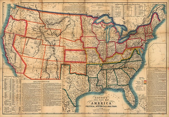
English: Scale 1:5,702,400. LC Civil War Maps (2nd ed.), 36.8 "Federal free states" are outlined in red, "Federal slave states" are yellow, "Federal territories (free)" are orange, and "Confederate states (slave)" are green. Inset: Outline of England on the same scale. 13 x 10 cm. Includes population tables, "Extracts from the official census report of 1860," a brief description of the Federal navy, a table listing the "Positions of the American forts, North and South," a brief "politcal" overview, and a "Record of important events of the war, [battle fields herein named are underlined with red on the map]." The "Record" includes information from November 6, 1860, to July 15, 1863. Description derived from published bibliography. Available also through the Library of Congress web site as raster image. |
||
| Title | Bacon's steel plate map of America, political, historical & military. | ||
| Shelf ID | G3701.S5 1863 .B3 | ||
| Date | |||
| Source | https://www.loc.gov/item/99447105/ | ||
| Author | Bacon & Co. | ||
| Permission (Reusing this file) |
|
||
| Other versions |
|
||
| Location | United States | ||
| Part of | Military Battles And Campaigns · American Memory · Civil War Maps · Catalog · Geography And Map Division | ||
| Subject | United States · Maps · Civil War · History |


Licensing
[edit]
|
This is a faithful photographic reproduction of a two-dimensional, public domain work of art. The work of art itself is in the public domain for the following reason:
The official position taken by the Wikimedia Foundation is that "faithful reproductions of two-dimensional public domain works of art are public domain".
This photographic reproduction is therefore also considered to be in the public domain in the United States. In other jurisdictions, re-use of this content may be restricted; see Reuse of PD-Art photographs for details. | ||||
File history
Click on a date/time to view the file as it appeared at that time.
| Date/Time | Thumbnail | Dimensions | User | Comment | |
|---|---|---|---|---|---|
| current | 01:03, 18 May 2018 | | 10,250 × 7,080 (14.8 MB) | Fæ (talk | contribs) | LOC Maps https://www.loc.gov/item/99447105/ #10495 |
You cannot overwrite this file.
File usage on Commons
The following page uses this file: