File:BWphysisch.png
Jump to navigation
Jump to search

Size of this preview: 490 × 600 pixels. Other resolutions: 196 × 240 pixels | 392 × 480 pixels | 627 × 768 pixels | 1,222 × 1,496 pixels.
Original file (1,222 × 1,496 pixels, file size: 743 KB, MIME type: image/png)
Captions
Captions
Add a one-line explanation of what this file represents
| Description |
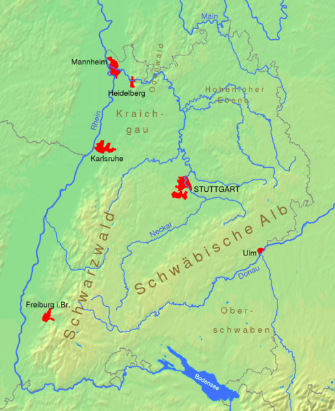
Deutsch: Physische Karte von Baden-Württemberg
English: Physical map of the German state of Baden-Württemberg
es: Mapa físico (incluye ubicación de aglomeraciones principales) Español: Mapa físico (incluye ubicación de aglomeraciones principales)
日本語: ヤクスト川と周辺の水系 図右上に「Hohenloher」という文字と重なってへの字型に流れているのがヤクスト川、すぐ南には「Ebene」という文字と重なってコッハー川が並行している。図の領域はほぼバーデン=ヴュルテンベルク州と重なる。 |
||||||||
| Date | |||||||||
| Source | made by myself, using eight data from [1] | ||||||||
| Author | Ssch | ||||||||
| Permission (Reusing this file) |
I, the copyright holder of this work, hereby publish it under the following licenses:
This file is licensed under the Creative Commons Attribution-Share Alike 2.0 Germany license.
 You may select the license of your choice. |
||||||||
| Other versions | Image:Karte Baden-Wuerttemberg physisch.png: similar map with SRTM3V2 relief map, using this map as source |

File history
Click on a date/time to view the file as it appeared at that time.
| Date/Time | Thumbnail | Dimensions | User | Comment | |
|---|---|---|---|---|---|
| current | 16:59, 2 October 2005 | | 1,222 × 1,496 (743 KB) | Ssch~commonswiki (talk | contribs) | Physical map of the German state of Baden-Württemberg. Height data taken from [http://www2.demis.nl/mapserver/maps.asp]. |
You cannot overwrite this file.
File usage on Commons
There are no pages that use this file.
File usage on other wikis
The following other wikis use this file:
- Usage on de.wikivoyage.org