File:Automobile road from Los Angeles to San Francisco via coast route. Part one- Los Angeles to Ventura, 1913 (AAA-SM-004665).jpg
Jump to navigation
Jump to search

Size of this preview: 800 × 281 pixels. Other resolutions: 320 × 112 pixels | 640 × 225 pixels | 1,024 × 360 pixels | 1,280 × 449 pixels | 2,560 × 899 pixels | 6,198 × 2,176 pixels.
Original file (6,198 × 2,176 pixels, file size: 2.8 MB, MIME type: image/jpeg)
Captions
Captions
Add a one-line explanation of what this file represents
Summary
[edit].jpg&action=edit§ion=1)
| Description |
English:
|
| Date | (date created) |
| Source | http://digitallibrary.usc.edu/cdm/ref/collection/p15799coll59/id/339 |
| Author | Unknown author |
Licensing
[edit].jpg&action=edit§ion=2)
This media file is in the public domain in the United States. This applies to U.S. works where the copyright has expired, often because its first publication occurred prior to January 1, 1929, and if not then due to lack of notice or renewal. See this page for further explanation.
|
 | |
 |
This image might not be in the public domain outside of the United States; this especially applies in the countries and areas that do not apply the rule of the shorter term for US works, such as Canada, Mainland China (not Hong Kong or Macao), Germany, Mexico, and Switzerland. The creator and year of publication are essential information and must be provided. See Wikipedia:Public domain and Wikipedia:Copyrights for more details.
|
File history
Click on a date/time to view the file as it appeared at that time.
| Date/Time | Thumbnail | Dimensions | User | Comment | |
|---|---|---|---|---|---|
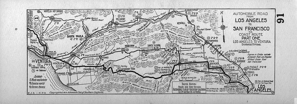
| current | 11:05, 31 January 2014 | 6,198 × 2,176 (2.8 MB) | Fæ (talk | contribs) | == {{int:filedesc}} == {{Information |description={{en|1=<br> :''Automobile road from Los Angeles to San Francisco via coast route. Part one: Los Angeles to Ventura, 1913 :Strip map of automobile route between Los Angeles and Ventura. Bounded by: Matil... |
You cannot overwrite this file.
File usage on Commons
There are no pages that use this file.
.jpg&oldid=877354677)