File:Australia and Papua are Melanesia.jpg
Jump to navigation
Jump to search
Size of this preview: 800 × 565 pixels. Other resolutions: 320 × 226 pixels | 640 × 452 pixels | 897 × 634 pixels.
Original file (897 × 634 pixels, file size: 500 KB, MIME type: image/jpeg)
Captions
Captions
Add a one-line explanation of what this file represents
Summary
[edit]
| Description |
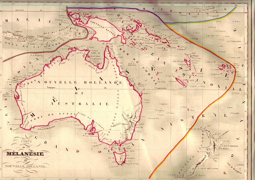
English: Soon after, in 1835, the first map with the name “Melanesia” was produced, with the drafting faithfully following the DU model. Engraved by Thierry, it will appear as map no. 86 in all the atlases “by Malte-Brun” (but posthumously: “new edition revised and corrected by J. J. N. Huot” etc., the editions of 1837, 1843, etc.). The 1843 edition is reproduced here: Précis de la Géographie Universelle ou Description de toutes les parties du monde sur un plan nouveau… par Malte-Brun, nouvelle édition revue, corrigée et augmentée… par J.-J.-N. Huot [Summary of the Universal Geography or Description of all of the parts of the world according to a new plan… by Malte-Brun, new edition, revised, corrected and augmented… by J.-J.-N. Huot], Paris, Bureau des Publications Illustrées, 1843. |
| Date | |
| Source | http://www.pacific-encounters.fr/cartographie_01_eng.php |
| Author | NLA |
Licensing
[edit]
|
This work is in the public domain in its country of origin and other countries and areas where the copyright term is the author's life plus 100 years or fewer. | |
| This file has been identified as being free of known restrictions under copyright law, including all related and neighboring rights. | |
File history
Click on a date/time to view the file as it appeared at that time.
| Date/Time | Thumbnail | Dimensions | User | Comment | |
|---|---|---|---|---|---|
| current | 08:44, 21 March 2014 | | 897 × 634 (500 KB) | Wplo.papua (talk | contribs) | User created page with UploadWizard |
You cannot overwrite this file.
File usage on Commons
There are no pages that use this file.
File usage on other wikis
The following other wikis use this file:
- Usage on en.wikipedia.org