File:Aurignacian culture map-de.svg
Jump to navigation
Jump to search

Size of this PNG preview of this SVG file: 720 × 540 pixels. Other resolutions: 320 × 240 pixels | 640 × 480 pixels | 1,024 × 768 pixels | 1,280 × 960 pixels | 2,560 × 1,920 pixels.
Original file (SVG file, nominally 720 × 540 pixels, file size: 417 KB)
Captions
Captions
Add a one-line explanation of what this file represents
| Description |
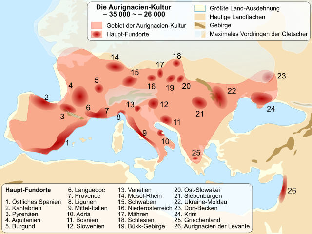
Deutsch: Karte der Aurignacien-Kultur zwischen 37 000 und 28 000 Jahren vor heute
Français : Carte de localisation de la culture Homo Sapiens de l'Aurignacien, il y a entre 37 000 et 28 000 ans.
English: Location map of Homo Sapiens Aurignacian culture, between 37,000 and 28,000 BP. French version. |
| Date | (UTC) |
| Source | |
| Author |
|
| This is a retouched picture, which means that it has been digitally altered from its original version. Modifications: Traduction allemand. The original can be viewed here: Aurignacian culture map-fr.svg:
|
I, the copyright holder of this work, hereby publish it under the following licenses:
| This file is licensed under the Creative Commons Attribution-Share Alike 3.0 Unported license. | ||
| ||
| This licensing tag was added to this file as part of the GFDL licensing update. |

|
Permission is granted to copy, distribute and/or modify this document under the terms of the GNU Free Documentation License, Version 1.2 or any later version published by the Free Software Foundation; with no Invariant Sections, no Front-Cover Texts, and no Back-Cover Texts. A copy of the license is included in the section entitled GNU Free Documentation License. |
You may select the license of your choice.
Original upload log
[edit]
This image is a derivative work of the following images:
- File:Aurignacian_culture_map-fr.svg licensed with Cc-by-sa-3.0-migrated, GFDL
- 2009-10-28T19:50:03Z Sémhur 720x540 (92824 Bytes) == {{int:filedesc}} == {{Information |Description= {{en|Location map of Homo Sapiens [[:en:Aurignacian|Aurignacian]] culture, between 37,000 and 28,000 BP. French version.}} {{fr|Carte de localisation de la culture Homo Sapie
Uploaded with derivativeFX
File history
Click on a date/time to view the file as it appeared at that time.
| Date/Time | Thumbnail | Dimensions | User | Comment | |
|---|---|---|---|---|---|
| current | 13:46, 29 May 2011 | | 720 × 540 (417 KB) | Furfur (talk | contribs) | {{Information |Description={{de|Karte der Aurignacien-Kultur zwischen 37 000 und 28 000 Jahre v. Chr.}} {{fr|Carte de localisation de la culture Homo Sapiens de l'Aurignacien, il y a entre 37 000 et 2 |
You cannot overwrite this file.
File usage on Commons
The following page uses this file:
File usage on other wikis
The following other wikis use this file:
- Usage on de.wikipedia.org
- Usage on et.wikipedia.org
- Usage on ja.wikipedia.org