File:Area 4, Oklahoma LOC 92684500.tif
Jump to navigation
Jump to search

Size of this JPG preview of this TIF file: 542 × 599 pixels. Other resolutions: 217 × 240 pixels | 434 × 480 pixels | 694 × 768 pixels | 926 × 1,024 pixels | 1,852 × 2,048 pixels | 5,894 × 6,518 pixels.
Original file (5,894 × 6,518 pixels, file size: 109.91 MB, MIME type: image/tiff)
Captions
Captions
Add a one-line explanation of what this file represents
Summary
[edit]| Description |
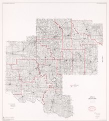
English: Shows Soil Conservation field office and soil conservation district boundaries in Hobart area, southwestern Oklahoma. Includes location map and source material note. Available also through the Library of Congress Web site as a raster image. |
||
| Title | Area 4, Oklahoma | ||
| Shelf ID | G4024.H6J4 1990 .U5 | ||
| Date | |||
| Source | https://www.loc.gov/item/92684500/ | ||
| Author | United States. Soil Conservation Service; National Cartographic Center (U.S.) | ||
| Permission (Reusing this file) |
|
||
| Other versions |
|
||
| Location | United States · Hobart Region. · Hobart Region · Oklahoma | ||
| Part of | American Memory · Cities And Towns · Catalog · Geography And Map Division · Additional Conservation And Environment Cartographic Items | ||
| Subject | Soil Conservation Service · Oklahoma · United States · Maps · Soil Conservation Districts · Hobart Region |


Licensing
[edit]| This work is from the Library of Congress. According to the library, there are no known copyright restrictions on the use of this work. |  |
File history
Click on a date/time to view the file as it appeared at that time.
| Date/Time | Thumbnail | Dimensions | User | Comment | |
|---|---|---|---|---|---|
| current | 16:28, 30 June 2019 |  | 5,894 × 6,518 (109.91 MB) | Fæ (talk | contribs) | LOC Maps https://www.loc.gov/item/92684500/ #24984 |
You cannot overwrite this file.
File usage on Commons
The following page uses this file: