File:Archeologische kaart Romeins Rijnland-Delfland in Zuid-Holland.svg
Jump to navigation
Jump to search

Size of this PNG preview of this SVG file: 378 × 600 pixels. Other resolutions: 151 × 240 pixels | 302 × 480 pixels | 484 × 768 pixels | 645 × 1,024 pixels | 1,291 × 2,048 pixels | 807 × 1,280 pixels.
Original file (SVG file, nominally 807 × 1,280 pixels, file size: 115 KB)
Captions
Captions
Add a one-line explanation of what this file represents
Summary
[edit]
This vector image was created with Inkscape .
| Description |
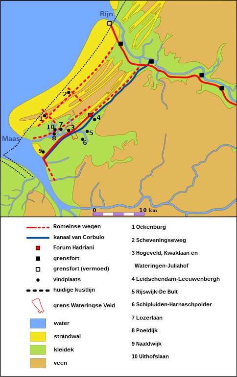
Nederlands: Overzicht van de vindplaatsen en infrastructuur tussen de Maas- en Rijnmonding in de Romeinse tijd. Na een periode met zandverstuivingen is er in de Romeinse tijd opnieuw bewoning vanaf circa 75 tot 225 na Chr.
Zie ook: Simons en Lanzing (red.) 2009 en Archeologische Kroniek van Zuid-Holland, 43e jaargang, 2011.
English: Overview of the sites and infrastructure between the Meuse and Rhine estuary in Roman times. After a period with shifting sands, there is again occupancy from about 75 to 225 AD during the Roman times.
Also see: Simons & Lanzing (ed.) 2009 and "Archeologische Kroniek van Zuid-Holland", 43rd year, 2011.
Deutsch: Übersicht über die Standorte und Infrastruktur zwischen Maas und Rhein-Mündung in der Römerzeit . Nach einer Zeit mit Treibsand , gibt es wieder Belegung von etwa 75 bis 225 AD in der Römerzeit .
Français : Vue d'ensemble des sites et des infrastructures entre l'estuaire de la Meuse et du Rhin à l'époque romaine. Après une période avec des sables mouvants, il y a encore une fois l'occupation d'environ 75 à 225 AD à l'époque romaine.
Español: Vista general de los sitios e infraestructura entre el estuario del Mosa y Rin, en la época romana. Después de un período de arenas movedizas, no es nuevo ocupación de aproximadamente 75 a 225 dC en la época romana. |
| Date | |
| Source | Own work |
| Author | OSeveno, based on bitmap File:Netherlands, area around The Hague in the 2nd Century AD.jpg by Vincent van Zeijst |
Licensing
[edit]
I, the copyright holder of this work, hereby publish it under the following license:
This file is licensed under the Creative Commons Attribution-Share Alike 4.0 International license.
- You are free:
- to share – to copy, distribute and transmit the work
- to remix – to adapt the work
- Under the following conditions:
- attribution – You must give appropriate credit, provide a link to the license, and indicate if changes were made. You may do so in any reasonable manner, but not in any way that suggests the licensor endorses you or your use.
- share alike – If you remix, transform, or build upon the material, you must distribute your contributions under the same or compatible license as the original.
File history
Click on a date/time to view the file as it appeared at that time.
| Date/Time | Thumbnail | Dimensions | User | Comment | |
|---|---|---|---|---|---|
| current | 15:38, 9 April 2018 | | 807 × 1,280 (115 KB) | OSeveno (talk | contribs) | adjusted color green |
| 15:33, 9 April 2018 |  | 807 × 1,280 (115 KB) | OSeveno (talk | contribs) | Adjusted map | |
| 07:36, 7 June 2016 |  | 765 × 1,342 (107 KB) | OSeveno (talk | contribs) | Minor correction | |
| 18:08, 28 May 2016 |  | 765 × 1,342 (107 KB) | OSeveno (talk | contribs) | Adjusted lay-out | |
| 18:07, 28 May 2016 |  | 765 × 1,342 (107 KB) | OSeveno (talk | contribs) | Adjusted lay-out | |
| 18:03, 28 May 2016 |  | 765 × 1,342 (106 KB) | OSeveno (talk | contribs) | User created page with UploadWizard |
You cannot overwrite this file.
File usage on Commons
There are no pages that use this file.