File:Arabia WDL2920.png
Jump to navigation
Jump to search
Size of this preview: 800 × 510 pixels. Other resolutions: 320 × 204 pixels | 640 × 408 pixels | 1,024 × 653 pixels | 1,280 × 817 pixels | 1,605 × 1,024 pixels.
Original file (1,605 × 1,024 pixels, file size: 3.15 MB, MIME type: image/png)
Captions
Captions
Add a one-line explanation of what this file represents
Summary
[edit]| Русский: Аравия
Français : Arabie English: Arabia 中文:阿拉伯半岛 Português: Arábia العربية: شبه الجزيرة العربية Español: Arabia |
|
|---|---|
| Author |
Русский: Хондиус, Йодокус, 1563-1612 гг.
Français : Hondius, Jodocus, 1563-1612
English: Hondius, Jodocus, 1563-1612
中文:洪第乌斯, 约道库斯,1563-1612 年
Português: Hondius, Jodocus, 1563-1612
العربية: هونديوس، جودوكس، 1563-1612
Español: Hondius, Jodocus, 1563-1612 |
| Title |
Русский: Аравия
Français : Arabie
English: Arabia
中文:阿拉伯半岛
Português: Arábia
العربية: شبه الجزيرة العربية
Español: Arabia |
| Description |
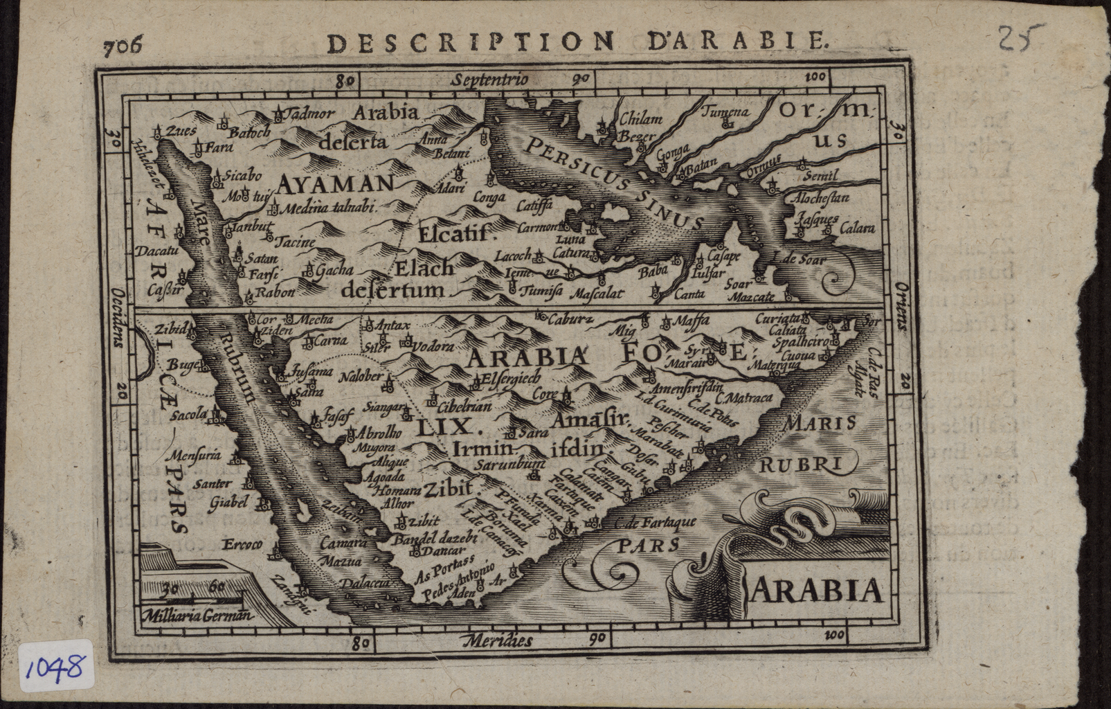
Русский: Эта карта 1616 года с латинскими топонимами перепечатана с работы Йодокуса Хондиуса (1563-1612 гг.) — фламандского картографа и гравера, поселившегося в Амстердаме примерно в 1593 году и основавшего фирму по производству глобусов и первых крупных карт мира. Топонимы напечатаны неразборчиво. На многих старых картах "Короманис" расположен на территории современного Кувейта, однако, согласно этой карте, он находится за Катиффой (Catiffa), или Аль Катиф (Al Qatif). Возможно, что Луна (Luna) в прибрежной зоне Персидского залива это Рас Танурах, расположенный недалеко от Кармониса. (Некоторые историки полагают, что "Кармон" или "Кармонис" происходит от арабского названия Хор Омани, который отмечен на картах в разных местах на побережье Аравийского залива). Существует возможность, что это место — "Кор Бобиан", или по-арабски Хор Бобиан. Город со странным названием Баба изображен на реке, протекающей по территории современных Объединенных Арабских Эмиратов. За Джульфаром находится Кассап (Cassape) — название, остающееся загадкой для современных ученых. Катар и Бахрейн отмечены на этой карте нечетко, и разобрать их очертания очень сложно.
Аравийский залив; Аравийский полуостров; Персидский залив Français : Cette carte de 1616, portant des noms de lieux en latin, est une réimpression d'une œuvre de Jodocus Hondius (1563-1612), un graveur et cartographe flamand, qui s'installa à Amsterdam en 1593 et créa une entreprise qui produisit des globes ainsi que les premières grandes cartes du monde. Les noms de lieux sur la carte ne sont pas clairs. “Coromanis” est indiqué sur plusieurs cartes plus anciennes comme étant situé dans l'actuel Koweït, mais ici il est montré comme étant au-delà de “Catiffa,” ou Al Qatif. “Luna,” sur la ceinture côtière du Golfe Arabique, pourrait être Ras Tanurah, situé près de “Carmonis.” (Certains historiens estiment que "Carmon" ou "Carmonis" est dérivé du nom arabe, Khor Omani, que plusieurs cartes montrent en différents points sur la côte du Golfe Arabique.) Ce lieu pourrait être également "Cor Bobian", ou le Khor Bobian arabique. Une ville portant le nom étrange de "Baba" est montrée près d'une rivière placée sur le territoire des actuels Émirats Arabes Unis. Au-delà de Julfar se trouve "Cassape", un nom que les chercheurs modernes ne peuvent expliquer. Le Qatar et Bahreïn sont représentés d'une manière ambiguë sur cette carte et sont difficilement identifiables.
Golfe Arabique; Péninsule arabique; Golfe Persique English: This map of 1616, with Latin place names, is a reprint of a work by Jodocus Hondius (1563-1612), a Flemish cartographer and engraver who settled in Amsterdam in about 1593 and established a business that produced globes and the first large maps of the world. The place names on the map are unclear. “Coromanis” is shown on many older maps as located in present-day Kuwait, but here is shown as lying beyond “Catiffa,” or Al Qatif. “Luna,” on the coastal belt of the Arabian Gulf, could be Ras Tanurah, located near “Carmonis.” (Some historians believe that “Carmon” or “Carmonis” is derived from the Arabic name, Khor Omani, which various maps show at different points on the coast of the Arabian Gulf.) This place also could be “Cor Bobian,” or the Arabic Khor Bobian. A town with the strange name of “Baba” is shown adjacent to a river placed on the territory of the present-day United Arab Emirates. Beyond Julfar is “Cassape,” a name that is not understood by modern scholars. Qatar and Bahrain are ambiguously represented on this map, and difficult to identify.
Arabian Gulf; Arabian Peninsula; Persian Gulf 中文:这幅 1616 年采用拉丁语地名的地图是对约斯·洪第乌斯(1563-1612年)所绘地图的重印版,约斯·洪第乌斯是一位佛兰芒制图师与雕刻师,1593 年左右他定居阿姆斯特丹,成立了一家公司,该公司生产地球仪,并出版了首批大型世界地图。 这幅地图上的地名都不清楚。 在很多更早的地图中“Coromanis ”都位于当今的科威特境内,但是在这幅地图上却位于“Catiffa ”或 Al Qatif 以外的地区。 位于阿拉伯湾沿海地带的“Luna” 可能是 Ras Tanurah,位于“Carmonis”附近。 有些历史学家认为“Carmon”或“Carmonis”源自阿拉伯语的名称 Khor Omani,很多不同的地图所标注的该地点都位于阿拉伯海湾沿海的不同位置上。 该地点还可能是“Cor Bobian”或阿拉伯语中的 Khor Bobian。 该地图上位于今天阿拉伯联合酋长国境内一条河流的旁边有一处标着奇怪名字“Baba”的城镇。 在 Julfar 外更远的地方有一处标着“Cassape”的地点,这个也是一处现代学者所不能理解的名称。 这幅地图上卡塔尔和巴林所代表的地区也很含糊,很难确定。
阿拉伯湾; 阿拉伯半岛; 波斯湾 Português: Este mapa de 1616, com topônimos em latim, é uma reedição de um trabalho de Jodocus Hondius (1563-1612), um cartógrafo e gravador flamengo que se instalou em Amesterdã por volta de 1593 e estabeleceu uma empresa que produzia globos e os primeiros mapas do mundo grandes . Os topônimos do mapa são imprecisos. "Coromanis" é apresentado em muitos mapas mais antigos como localizado no atual Kuwait, mas aqui é mostrado como situado bem além de "Catiffa", ou Al Qatif. "Luna", na faixa costeira do Golfo Árabe, poderia ser Tanurah Ras, situada próximo a "Carmonis". (Alguns historiadores acreditam que "Carmon" ou "Carmonis" é derivado do nome árabe, Khor Omani, que vários mapas mostram em diferentes pontos da costa do Golfo Árabe.) Este local também poderia ser "Cor Bobian" ou o Khor Bobian árabe. Uma cidade com o estranho nome de "Baba" é mostrada junto a um rio localizado no território dos atuais Emirados Árabes Unidos. Além de Julfar está "Cassape", um nome que não é compreendido por estudiosos modernos. Catar e Bahrein estão ambiguamente representadas neste mapa e são de difícil identificação.
Golfo Arábico; Península Arábica; Golfo Pérsico العربية: هذه الخريطة من 1616، والتي تحتوي على أسماء الأماكن باللاتينية، إعادة طبعة لعمل لجودوكس هندويس (1563-1612) وهو رسام خرائط ونقاش فلمنكي استقر في أمستردام في حوالي 1593 وأسس عملا لإنتاج أول خرائط ضخمة للعالم. إن أسماء الأماكن على الخريطة غير واضحة. تظهر "كورومانيس" على العديد من الخرائط القديمة في الكويت حاليا، بينما تظهر هنا ما بعد "كتيفة"، أو القطيف. ومن الممكن أن تكون "لونا"، التي تقع على الحزام الساحلي للخليج العربي، رأس التنورة، الواقعة بالقرب من "كارمونيس". ويعتقد بعض المؤرخين أن "كارمون" أو "كارمونيس" مشتقة من الاسم العربي خور عماني، الذي يظهر في نقاط مختلفة على ساحل الخليج العربي. ومن الممكن أن يكون هذا المكان "كور بوبيان"، أو خور بوبيان باللغة العربية. وهناك مدينة لها اسم غريب، "بابا"، وهي متاخمة لنهر وُضع على أراضي دولة الإمارات العربية المتحدة حاليا. تقع جلفار بعد "كاساب"، وهو اسم لا يفهمه الباحثون العصريون. وتمثل قطر والبحرين في شكل غامض على الخريطة، كما يصعب تحديدهما.
الخليج العربي; شبه الجزيرة العربية; الخليج الفارسي Español: Este mapa de 1616, con nombres de lugares en latín, es una reedición de una obra de Jodocus Hondius (1563-1612), un cartógrafo y grabador flamenco que se estableció en Amsterdam alrededor de 1593 y cómenzó una empresa que producía globos terráqueos y los primeros mapas grandes del mundo. Los nombres de lugares en el mapa no son claros. "Coromanis" aparece en muchos de los antiguos mapas ubicado en el actual Kuwait, pero aquí se muestra más allá de "Catiffa" o Al Qatif. "Luna", en la franja costera del Golfo Arábigo, podría ser Ras Tanurah, ubicado cerca de "Carmonis". (Algunos historiadores creen que "Carmon" o "Carmonis" se deriva del nombre árabe, Khor Omani, que varios mapas muestran en diferentes puntos de la costa del Golfo Arábigo). Este lugar también podría ser "Cor Bobian" o Khor Bobian de Arabia. Un pueblo con el extraño nombre de "Baba" se muestra al lado de un río en el territorio de los actuales Emiratos Árabes Unidos. Más allá de Julfar está "Cassape", un nombre que los estudiosos modernos no comprenden. Catar y Bahrain son representados de manera ambigua en este mapa y son difíciles de identificar.
Golfo Arábigo; Península de Arabia; Golfo Pérsico |
| Date | 1616 |
| Medium |
Русский: Карты
Français : Cartes
English: Maps
中文:地图
Português: Mapas
العربية: خرائط
Español: Mapas |
| Dimensions |
English: 1 map; black and white; 8.50 x 12.10 centimeters |
| Collection |
Русский: Национальная библиотека Катара
Français : Bibliothèque nationale du Qatar
English: Qatar National Library
中文:卡塔尔国家图书馆
Português: Biblioteca Nacional do Catar
العربية: مكتبة قطر الوطنية
Español: Biblioteca Nacional de Catar |
| Place of creation |
Русский: Бахрейн
Français : Bahreïn
English: Bahrain
中文:巴林
Português: Bareine
العربية: البحرين
Español: Baréin |
| Source/Photographer |
|
| Other versions |
|

Licensing
[edit]
|
This is a faithful photographic reproduction of a two-dimensional, public domain work of art. The work of art itself is in the public domain for the following reason:
The official position taken by the Wikimedia Foundation is that "faithful reproductions of two-dimensional public domain works of art are public domain".
This photographic reproduction is therefore also considered to be in the public domain in the United States. In other jurisdictions, re-use of this content may be restricted; see Reuse of PD-Art photographs for details. | ||||
File history
Click on a date/time to view the file as it appeared at that time.
| Date/Time | Thumbnail | Dimensions | User | Comment | |
|---|---|---|---|---|---|
| current | 13:23, 11 March 2014 | | 1,605 × 1,024 (3.15 MB) | Fæ (talk | contribs) | =={{int:filedesc}}== {{Artwork |artist = |author ={{ru|1=Хондиус, Йодокус, 1563-1612 гг.}} {{fr|1=Hondius, Jodocus, 1563-1612}} {{en|1=Hondius, Jodocus, 1563-1612}} {{zh|1=洪第乌斯, 约道库斯,1563-1612 年}} {{pt|1=Hondius, Jo... |
You cannot overwrite this file.
File usage on Commons
The following 2 pages use this file: