File:Antietam0900 a.svg
Jump to navigation
Jump to search

Size of this PNG preview of this SVG file: 473 × 561 pixels. Other resolutions: 202 × 240 pixels | 405 × 480 pixels | 647 × 768 pixels | 863 × 1,024 pixels | 1,727 × 2,048 pixels.
Original file (SVG file, nominally 473 × 561 pixels, file size: 2.99 MB)
Captions
Captions
Add a one-line explanation of what this file represents
W3C-validity not checked.
Summary
[edit]
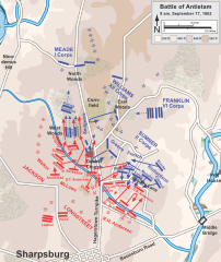
| Description | Map of the Battle of Antietam of the American Civil War. Drawn in Adobe Illustrator CS5 by Hal Jespersen. Graphic source file is available at http://www.posix.com/CWmaps/ |
| Date | (UTC) |
| Source |
This file was derived from: Antietam0900.png:  |
| Author |
|
| This is a retouched picture, which means that it has been digitally altered from its original version. Modifications: SVG-file of AI-file. The original can be viewed here: Antietam0900.png:
|
Licensing
[edit]
I, the copyright holder of this work, hereby publish it under the following license:
This file is licensed under the Creative Commons Attribution 3.0 Unported license.
- You are free:
- to share – to copy, distribute and transmit the work
- to remix – to adapt the work
- Under the following conditions:
- attribution – You must give appropriate credit, provide a link to the license, and indicate if changes were made. You may do so in any reasonable manner, but not in any way that suggests the licensor endorses you or your use.
Original upload log
[edit]
This image is a derivative work of the following images:
- File:Antietam0900.png licensed with Cc-by-3.0
- 2011-09-27T21:25:40Z Hlj 789x935 (362665 Bytes) Provide more exact topographical information. Same license.
- 2011-03-28T19:49:26Z Hlj 794x957 (248283 Bytes) Update to more recent graphical style for rivers and roads. Same license.
- 2010-10-26T01:19:37Z Hlj 794x957 (226780 Bytes) Updated graphics to conform to style used by many other ACW maps, added legend/scale. Drawn in Adobe Illustrator CS5 by Hal Jespersen. Graphic source file is available at http://www.posix.com/CWmaps/ {{cc-by-3.0|Map by Hal Je
- 2007-04-15T09:12:57Z Hellisp 756x922 (272622 Bytes) Map of the Battle of Antietam of the American Civil War, actions starting at 9 a.m. Drawn by Hal Jespersen in Macromedia Freehand. Graphic source file is available at http://www.posix.com/CWmaps/ {{PD-release}} From en.wiki
Uploaded with derivativeFX
File history
Click on a date/time to view the file as it appeared at that time.
| Date/Time | Thumbnail | Dimensions | User | Comment | |
|---|---|---|---|---|---|
| current | 19:11, 8 May 2013 | | 473 × 561 (2.99 MB) | Citypeek (talk | contribs) | == {{int:filedesc}} == {{Information |Description=Map of the Battle of Antietam of the American Civil War. Drawn in Adobe Illustrator CS5 by Hal Jespersen. Graphic source file is available at http://www.posix.com/CWmaps/ |Source={{Derived from|Anti... |
You cannot overwrite this file.
File usage on Commons
The following page uses this file:
File usage on other wikis
The following other wikis use this file:
- Usage on de.wikipedia.org
- Usage on ja.wikipedia.org
- Usage on nl.wikipedia.org