File:Anglo-Zanzibar war map-pt.png
Jump to navigation
Jump to search

Size of this preview: 740 × 600 pixels. Other resolutions: 296 × 240 pixels | 592 × 480 pixels | 818 × 663 pixels.
Original file (818 × 663 pixels, file size: 443 KB, MIME type: image/png)
Captions
Captions
Add a one-line explanation of what this file represents
Summary
[edit]
| Description |
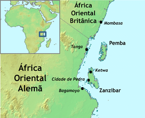
Português: Versão em português do mapa mostrando a localização da Cidade de Pedra em Zanzibar, e a localização de Zanzibar em relação à África.
English: Portuguese version of a map showing Zanzibar Town's location in Zanzibar, and Zanzibar's location relative to Africa. |
| Date | |
| Source | File:Anglo-Zanzibar war map.png |
| Author | Melancolicsphere (talk) 22:59, 9 August 2009 (UTC) |
| Permission (Reusing this file) |
CC-BY-3.0. |
| Other versions |
 |
Licensing
[edit]
This file is licensed under the Creative Commons Attribution 3.0 Unported license.
- You are free:
- to share – to copy, distribute and transmit the work
- to remix – to adapt the work
- Under the following conditions:
- attribution – You must give appropriate credit, provide a link to the license, and indicate if changes were made. You may do so in any reasonable manner, but not in any way that suggests the licensor endorses you or your use.
File history
Click on a date/time to view the file as it appeared at that time.
| Date/Time | Thumbnail | Dimensions | User | Comment | |
|---|---|---|---|---|---|
| current | 22:59, 9 August 2009 | | 818 × 663 (443 KB) | Melancolicsphere (talk | contribs) | {{Information |Description={{pt|Versão em português do mapa mostrando a localização da Cidade de Pedra em Zanzibar, e a localização de Zanzibar em relação à África.}} {{en|Portuguese version of a map showing Zanzibar Town's location in Zanzibar, |
You cannot overwrite this file.
File usage on Commons
There are no pages that use this file.
File usage on other wikis
The following other wikis use this file:
- Usage on es.wikipedia.org
- Usage on pt.wikipedia.org