File:Ancient colonies.PNG
Jump to navigation
Jump to search

Size of this preview: 800 × 400 pixels. Other resolutions: 320 × 160 pixels | 640 × 320 pixels | 1,024 × 512 pixels | 1,280 × 639 pixels | 2,500 × 1,249 pixels.
Original file (2,500 × 1,249 pixels, file size: 761 KB, MIME type: image/png)
Captions
Captions
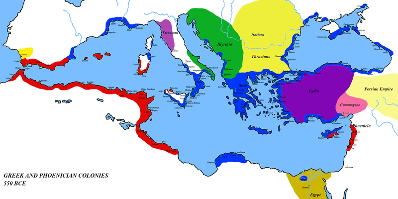
Map of the colonies of Ancient Greece and Phoenicia — circa 550 BCE. Phoenicia and Phoenician colonial areas in red, Greece and Greek colonial areas in blue; other areas as marked.
Summary
[edit]
| Description |
English: Map of the colonies of Ancient Greece and Phoenicia — circa 550 BCE.
|
| Date | 1 March 2008 (original upload date) |
| Source | Own work (Original text: self-made) |
| Author | Javierfv1212 (talk) |
| Other versions | العربيَّة |
Licensing
[edit]
| This work has been released into the public domain by its author, Javierfv1212 at English Wikipedia. This applies worldwide. In some countries this may not be legally possible; if so: Javierfv1212 grants anyone the right to use this work for any purpose, without any conditions, unless such conditions are required by law. |
Original upload log
[edit]
Transferred from en.wikipedia to Commons by Javierfv1212.
The original description page was here. All following user names refer to en.wikipedia.
- 2008-03-08 15:09 Megistias 2500×1249× (768071 bytes) == Summary == {{Information |Description=Greek and Phoenecian colonies about 550 bc |Source=self-made |Date= |Location= |Author=[[User:Javierfv1212|Javierfv1212]] ([[User talk:Javierfv1212|talk]]),Modified by [[User:Megistias]] in the illyrian,thracian,gr
- 2008-03-01 03:09 Javierfv1212 2500×1249× (819010 bytes) {{Information |Description=Greek and Phoenecian colonies about 550 bc |Source=self-made |Date= |Location= |Author=~~~ |other_versions= }}
File history
Click on a date/time to view the file as it appeared at that time.
| Date/Time | Thumbnail | Dimensions | User | Comment | |
|---|---|---|---|---|---|
| current | 20:33, 23 February 2014 | | 2,500 × 1,249 (761 KB) | Spiridon Ion Cepleanu (talk | contribs) | Little changes since H.E. Stier (dir.), Westermann Grosser Atlas zur Weltgeschichte, 1985, ISBN 3-14-100919-8 |
| 03:45, 11 June 2012 |  | 2,500 × 1,249 (750 KB) | OgreBot (talk | contribs) | (BOT): Reverting to most recent version before archival | |
| 03:41, 11 June 2012 |  | 2,500 × 1,249 (800 KB) | OgreBot (talk | contribs) | (BOT): Uploading old version of file from en.wikipedia; originally uploaded on 2008-03-01 03:09:18 by Javierfv1212 | |
| 19:47, 27 January 2012 |  | 2,500 × 1,249 (750 KB) | 배우는사람 (talk | contribs) | {{Information |Description={{en|Greek and Phoenician colonies about 550 bc}} |Source=Transferred from [http://en.wikipedia.org en.wikipedia]; transfer was stated to be made by User:Javierfv1212.<br/> (Original text : ''self-made'') |Date={{Date|2008|0 |
You cannot overwrite this file.
File usage on Commons
The following page uses this file:
File usage on other wikis
The following other wikis use this file:
- Usage on ar.wikipedia.org
- Usage on bg.wikipedia.org
- Usage on el.wikipedia.org
- Usage on en.wikipedia.org
- Usage on es.wikipedia.org
- Usage on es.wikibooks.org
- Usage on fa.wikipedia.org
- Usage on fi.wikipedia.org
- Usage on fr.wikipedia.org
- Usage on hr.wikipedia.org
- Usage on it.wikiversity.org
- Usage on ko.wikipedia.org
- Usage on mzn.wikipedia.org
- Usage on no.wikipedia.org
- Usage on pt.wikipedia.org
- Usage on ro.wikipedia.org
- Usage on ru.wikipedia.org
- Usage on sk.wikipedia.org
- Usage on sl.wikipedia.org
- Usage on sr.wikipedia.org
- Usage on uk.wikipedia.org
- Usage on www.wikidata.org
- Usage on zh.wikipedia.org
Metadata
Categories:
- Former colonies
- Maps of the Greek colonies
- Maps of Phoenicia
- 550s BC
- Maps of the European Antiquity
- Maps of the ancient Near East
- Maps of the history of North Africa
- Maps of the Mediterranean Basin
- Maps of former countries
- Maps of international relations
- Political history maps
- Maps of Phoenician colonies
- Regions of ancient Greece