File:An Analysis of fire stations in Arlington, Virginia LOC 2016586864.tif
Jump to navigation
Jump to search

Size of this JPG preview of this TIF file: 767 × 599 pixels. Other resolutions: 307 × 240 pixels | 615 × 480 pixels | 983 × 768 pixels | 1,280 × 1,000 pixels | 2,560 × 2,000 pixels | 6,748 × 5,272 pixels.
Original file (6,748 × 5,272 pixels, file size: 101.78 MB, MIME type: image/tiff)
Captions
Captions
Add a one-line explanation of what this file represents
Summary
[edit]| Description |
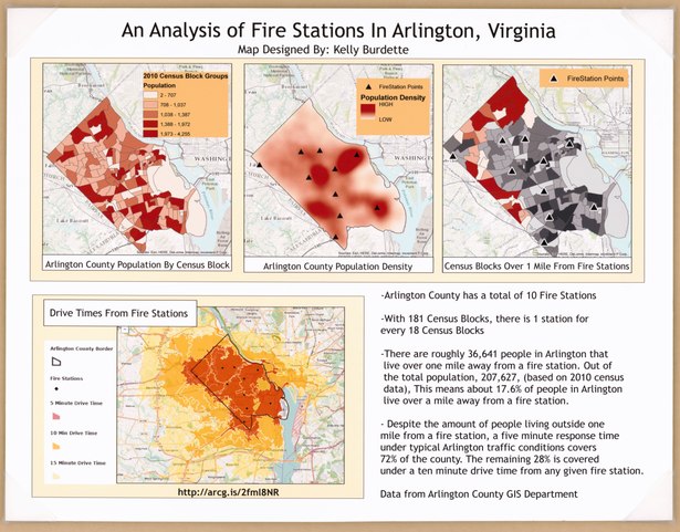
English: "Arlinkgton County has a total of 10 fire stations." "Data from Arlington County GIS Department." Made available through courtesy of Ryan Miller, Teacher, Arlington Public Schools. Also available in electronic format. Available also through the Library of Congress Web site as a raster image. Map on synthetic sheet affixed to top of foam-rubber base. Includes notes, population density map, and 2 "Census Block" maps. |
||
| Title | An Analysis of fire stations in Arlington, Virginia | ||
| Shelf ID | G3883.A8G475 2016 .B8 | ||
| Date | |||
| Source | https://www.loc.gov/item/2016586864/ | ||
| Author | Burdette, Kelly; Arlington County (Va.). Gis Mapping Center | ||
| Permission (Reusing this file) |
|
||
| Other versions |
|
||
| Location | United States · Arlington County. · Arlington County · Virginia | ||
| Part of | American Memory · General Maps · Catalog · Geography And Map Division | ||
| Subject | Arlington County · Virginia · United States · Maps · Rescue Work · Fire Stations |


Licensing
[edit]| This work is from the Library of Congress. According to the library, there are no known copyright restrictions on the use of this work. |  |
File history
Click on a date/time to view the file as it appeared at that time.
| Date/Time | Thumbnail | Dimensions | User | Comment | |
|---|---|---|---|---|---|
| current | 05:08, 10 May 2018 |  | 6,748 × 5,272 (101.78 MB) | Fæ (talk | contribs) | LOC Maps https://www.loc.gov/item/2016586864/ #2272 |
You cannot overwrite this file.
File usage on Commons
The following page uses this file: