File:Americae sive novi orbis, nova descriptio. NYPL465007.tiff
Jump to navigation
Jump to search

Size of this JPG preview of this TIF file: 800 × 588 pixels. Other resolutions: 320 × 235 pixels | 640 × 470 pixels | 1,024 × 753 pixels | 1,280 × 941 pixels | 2,560 × 1,882 pixels | 5,458 × 4,012 pixels.
Original file (5,458 × 4,012 pixels, file size: 62.66 MB, MIME type: image/tiff)
Captions
Captions
Add a one-line explanation of what this file represents
Summary
[edit]| Description | Americae sive novi orbis, nova descriptio. | |||||||||||||||||||||||
| Notes | National Endowment for the Humanities Grant for Access to Early Maps of the Middle Atlantic Seaboard. Note 2.) Appears in Ortelius's Theatrum orbis terrarum. Note 3.) At lower right corner on verso: 2. Note 4.) Described in Schwartz & Ehrenberg's Mapping of America. Note 5.) Includes decorative cartouche and ill. Note 6.) John H. Levine Bequest. Note 7.) Relief shown pictorially. Note 8.) State 2 according to Burden. Azores are labelled. Note 9.) Text on verso: Novvs Orbis. | |||||||||||||||||||||||
| Standard reference | Ermen, E. van. United States in old maps and prints, pl. 2; Phillips 374; Burden, P.D. Mapping of North America, 39 | |||||||||||||||||||||||
| Physical description | 1 map : hand col. ; 36 x 50 cm. | |||||||||||||||||||||||
| Catalog Call Number | Map Div. 97-7390 [Levine] | |||||||||||||||||||||||
| Date | circa 1573 | |||||||||||||||||||||||
| Source |
http://digitalgallery.nypl.org/nypldigital/dgkeysearchdetail.cfm?imageID=465007
|
|||||||||||||||||||||||
| Author | Ortelius, Abraham, 1527-1598 -- Cartographer | |||||||||||||||||||||||
| Permission (Reusing this file) |
From The Lionel Pincus & Princess Firyal Map Division. Released on a CC0 license.[1] | |||||||||||||||||||||||
| Digital ID | 465007 | |||||||||||||||||||||||
| Location | Stephen A. Schwarzman Building / The Lionel Pincus and Princess Firyal Map Division | |||||||||||||||||||||||
| NYPL digital item published | 2-3-2004; updated 3-25-2011 | |||||||||||||||||||||||

Licensing
[edit]| This file is made available under the Creative Commons CC0 1.0 Universal Public Domain Dedication. | |
| The person who associated a work with this deed has dedicated the work to the public domain by waiving all of their rights to the work worldwide under copyright law, including all related and neighboring rights, to the extent allowed by law. You can copy, modify, distribute and perform the work, even for commercial purposes, all without asking permission.
|
The making of this file was supported by Wikimedia UK.
To see other files made with the support of Wikimedia UK, please see the category Supported by Wikimedia UK.
|
File history
Click on a date/time to view the file as it appeared at that time.
| Date/Time | Thumbnail | Dimensions | User | Comment | |
|---|---|---|---|---|---|
| current | 16:28, 3 May 2023 |  | 5,458 × 4,012 (62.66 MB) | LlywelynII (talk | contribs) | Cropped using CropTool. |
| 18:03, 6 April 2020 |  | 6,107 × 4,936 (86.25 MB) | SteinsplitterBot (talk | contribs) | Bot: Image rotated by 270° | |
| 00:08, 5 April 2014 | 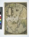 | 4,936 × 6,107 (86.25 MB) | Fæ (talk | contribs) | =={{int:filedesc}}== {{NYPL_map |digital_id = 465007 |standard_reference = Ermen, E. van. United States in old maps and prints, pl. 2; Phillips 374; Burden, P.D. Mapping of North America, 39 |record_id = 292172 |catalog_call_number = Map Div. 97-7390 [... |
You cannot overwrite this file.
File usage on Commons
The following page uses this file: