File:Alpen zwischen Salzkammergut und Neusiedler See.png
Jump to navigation
Jump to search
Size of this preview: 732 × 599 pixels. Other resolutions: 293 × 240 pixels | 586 × 480 pixels | 938 × 768 pixels | 1,251 × 1,024 pixels | 2,502 × 2,048 pixels | 5,204 × 4,260 pixels.
Original file (5,204 × 4,260 pixels, file size: 6.38 MB, MIME type: image/png)
Captions
Captions
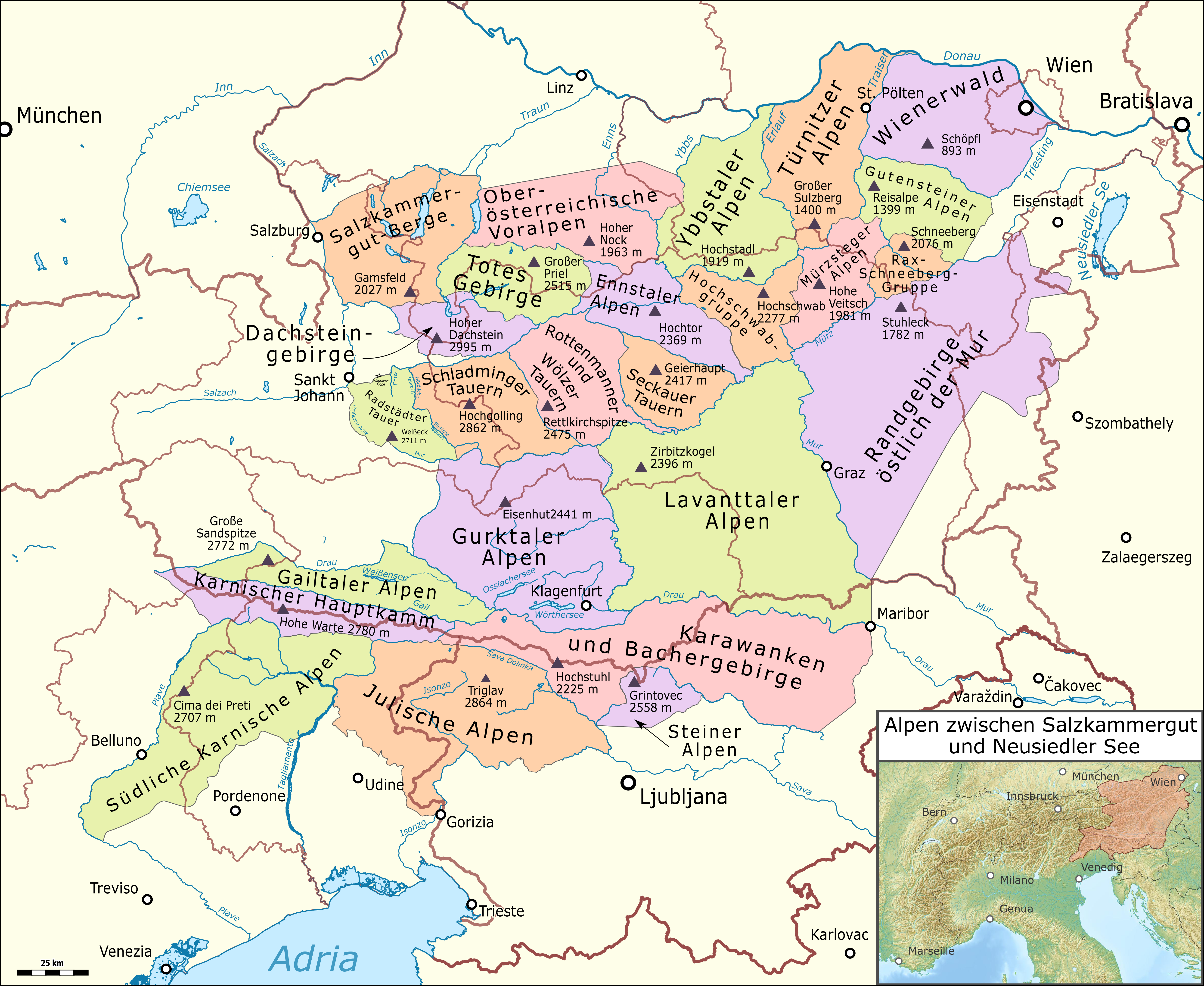
Mountain ranges of the Alps between Salzkammergut and Lake Neusiedl
Summary
[edit]
| Description |
Deutsch: Alpen zwischen Salzkammergut und Neusiedler See |
|||||||||
| Date | ||||||||||
| Source |
Map was created using:
|
|||||||||
| Creator |
|
|||||||||
| Permission (Reusing this file) |
Map data (c) OpenStreetMap (and) contributors, CC-BY-SA | |||||||||
| Geotemporal data | ||||||||||
| Bounding box |
|
|||||||||
| Georeferencing | ||||||||||
I, the copyright holder of this work, hereby publish it under the following licenses:

|
Permission is granted to copy, distribute and/or modify this document under the terms of the GNU Free Documentation License, Version 1.2 or any later version published by the Free Software Foundation; with no Invariant Sections, no Front-Cover Texts, and no Back-Cover Texts. A copy of the license is included in the section entitled GNU Free Documentation License. |
This file is licensed under the Creative Commons Attribution-Share Alike 3.0 Unported license.
- You are free:
- to share – to copy, distribute and transmit the work
- to remix – to adapt the work
- Under the following conditions:
- attribution – You must give appropriate credit, provide a link to the license, and indicate if changes were made. You may do so in any reasonable manner, but not in any way that suggests the licensor endorses you or your use.
- share alike – If you remix, transform, or build upon the material, you must distribute your contributions under the same or compatible license as the original.
You may select the license of your choice.
| This work is licensed under the Open Database License (summary). |
File history
Click on a date/time to view the file as it appeared at that time.
| Date/Time | Thumbnail | Dimensions | User | Comment | |
|---|---|---|---|---|---|
| current | 02:27, 7 October 2021 | | 5,204 × 4,260 (6.38 MB) | Pechristener (talk | contribs) | Tipo Julische Alpen behoben |
| 22:36, 12 January 2019 |  | 5,551 × 4,544 (7.01 MB) | Pechristener (talk | contribs) | neue Farbschema, Radstätter Tauern hinzu | |
| 21:42, 8 January 2019 |  | 5,551 × 4,544 (6.86 MB) | Pechristener (talk | contribs) | typo Adria fixed | |
| 21:29, 8 January 2019 |  | 5,551 × 4,544 (6.86 MB) | Pechristener (talk | contribs) | == {{int:filedesc}} == {{Map |Description={{de|1=Alpen zwischen Salzkammergut und Neusiedler See}} |Source = Map was created using: *[http://www.openstreetmap.org/ Open Street Map] Data *Alps location map.png for location map |Author = *Einteilung: Pechristener *Alps location map.png: Lencer |Date =2018-01-08 |Permission =Map data (c) OpenStreetMap (and) cont... |
You cannot overwrite this file.
File usage on Commons
The following 6 pages use this file:
File usage on other wikis
The following other wikis use this file:
- Usage on de.wikipedia.org